DeKalb County, Indiana facts for kids
Quick facts for kids
DeKalb County
|
|
|---|---|

|
|

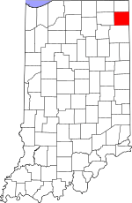
Location within the U.S. state of Indiana
|
|
 Indiana's location within the U.S. |
|
| Country | |
| State | |
| Founded | 7 February 1835 (authorized) 1837 (organized) |
| Named for | Johann, Baron de Kalb |
| Seat | Auburn |
| Largest city | Auburn |
| Area | |
| • Total | 363.85 sq mi (942.4 km2) |
| • Land | 362.82 sq mi (939.7 km2) |
| • Water | 1.03 sq mi (2.7 km2) 0.28%% |
| Population | |
| • Estimate
(2018)
|
43,226 |
| • Density | 119.1/sq mi (46.0/km2) |
| Time zone | UTC−5 (Eastern) |
| • Summer (DST) | UTC−4 (EDT) |
| Congressional district | 3rd |
| Website | DeKalb County Government |
| Indiana county number 17 | |
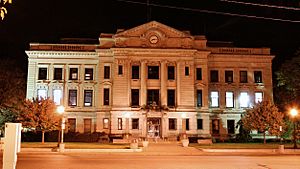
DeKalb County is a county in the U.S. state of Indiana. As of the 2010 United States Census, the population was 42,223. The county seat is Auburn.
Contents
History
DeKalb County was formed in 1837. It was named for the heroic General Johann de Kalb, a Continental Army officer from Bavaria, who was fatally wounded at the Battle of Camden, South Carolina. The original settlers to arrive in DeKalb County were migrants from New England who were settling the wilderness of what was then known as the Northwest Territory. These people were "Yankee" migrants, that is to say they were descended from the English Puritans who settled New England in the colonial era. In the 1870s immigrants from Ireland and Germany began arriving in DeKalb County, in large numbers.
Geography
According to the 2010 census, the county has a total area of 363.85 square miles (942.4 km2), of which 362.82 square miles (939.7 km2) (or 99.72%) is land and 1.03 square miles (2.7 km2) (or 0.28%) is water.
Cities and towns
Unincorporated communities
- Artic
- Auburn Junction
- Butler Center
- Cedar
- Concord
- Fairfield Center
- Hopewell
- Moore
- New Era
- Newville
- Orangeville
- Saint Johns
- Sedan
- Spencerville
- Stafford Center
- Summit
- Taylor Corner
Townships
- Butler
- Concord
- Fairfield
- Franklin
- Grant
- Jackson
- Keyser
- Newville
- Richland
- Smithfield
- Spencer
- Stafford
- Troy
- Union
- Wilmington
Major highways
 Interstate 69
 U.S. Route 6
 State Road 1
 State Road 3
 State Road 4
 State Road 8
 State Road 101
 State Road 205
 State Road 327
 State Road 427
Adjacent counties
- Steuben County (north)
- Williams County, Ohio (northeast)
- Defiance County, Ohio (southeast)
- Allen County (south)
- Noble County (west)
- LaGrange County (northwest)
Climate and weather
| Weather chart for Auburn, Indiana | |||||||||||||||||||||||||||||||||||||||||||||||
|---|---|---|---|---|---|---|---|---|---|---|---|---|---|---|---|---|---|---|---|---|---|---|---|---|---|---|---|---|---|---|---|---|---|---|---|---|---|---|---|---|---|---|---|---|---|---|---|
| J | F | M | A | M | J | J | A | S | O | N | D | ||||||||||||||||||||||||||||||||||||
|
1.8
31
17
|
1.4
36
20
|
2.6
48
29
|
3.4
61
39
|
3.7
72
49
|
4.2
81
58
|
3.7
84
62
|
2.8
82
60
|
3.6
75
54
|
2.7
63
43
|
3.2
49
34
|
2.5
37
23
|
||||||||||||||||||||||||||||||||||||
| temperatures in °F precipitation totals in inches source: The Weather Channel |
|||||||||||||||||||||||||||||||||||||||||||||||
|
Metric conversion
|
|||||||||||||||||||||||||||||||||||||||||||||||
In recent years, average temperatures in Auburn have ranged from a low of 17 °F (−8 °C) in January to a high of 84 °F (29 °C) in July, although a record low of −24 °F (−31 °C) was recorded in January 1984 and a record high of 106 °F (41 °C) was recorded in June 1988. Average monthly precipitation ranged from 1.42 inches (36 mm) in February to 4.17 inches (106 mm) in June.
Demographics
| Historical population | |||
|---|---|---|---|
| Census | Pop. | %± | |
| 1840 | 1,968 | — | |
| 1850 | 8,251 | 319.3% | |
| 1860 | 13,880 | 68.2% | |
| 1870 | 17,167 | 23.7% | |
| 1880 | 20,225 | 17.8% | |
| 1890 | 24,307 | 20.2% | |
| 1900 | 25,711 | 5.8% | |
| 1910 | 25,054 | −2.6% | |
| 1920 | 25,600 | 2.2% | |
| 1930 | 24,911 | −2.7% | |
| 1940 | 24,756 | −0.6% | |
| 1950 | 26,023 | 5.1% | |
| 1960 | 28,271 | 8.6% | |
| 1970 | 30,837 | 9.1% | |
| 1980 | 33,606 | 9.0% | |
| 1990 | 35,324 | 5.1% | |
| 2000 | 40,285 | 14.0% | |
| 2010 | 42,223 | 4.8% | |
| 2019 (est.) | 43,475 | 3.0% | |
| US Decennial Census 1790-1960 1900-1990 1990-2000 2010-2014 |
|||
As of the 2010 United States Census, there were 42,223 people, 15,951 households, and 11,328 families in the county. The population density was 116.4 inhabitants per square mile (44.9/km2). There were 17,558 housing units at an average density of 48.4 per square mile (18.7/km2). The racial makeup of the county was 96.9% white, 0.5% Asian, 0.4% black or African American, 0.2% American Indian, 0.8% from other races, and 1.2% from two or more races. Those of Hispanic or Latino origin made up 2.4% of the population. In terms of ancestry, 36.3% were German, 10.9% were American, 10.8% were Irish, and 9.1% were English.
Of the 15,951 households, 35.2% had children under the age of 18 living with them, 54.8% were married couples living together, 10.5% had a female householder with no husband present, 29.0% were non-families, and 24.3% of all households were made up of individuals. The average household size was 2.61 and the average family size was 3.08. The median age was 38.1 years.
The median income for a household in the county was $47,697 and the median income for a family was $55,280. Males had a median income of $44,880 versus $30,663 for females. The per capita income for the county was $21,779. About 6.7% of families and 9.0% of the population were below the poverty line, including 11.3% of those under age 18 and 6.2% of those age 65 or over.
Education
School districts
Private schools
- St. Joseph's Catholic School (Garrett)
- Zion Lutheran Pre-School (Garrett)
See also
 In Spanish: Condado de DeKalb (Indiana) para niños

