
Deerfield, Massachusetts facts for kids
Quick facts for kids
Deerfield, Massachusetts
|
||
|---|---|---|

Post office in Deerfield
|
||
|
||

Location in Franklin County in Massachusetts
|
||
| Country | United States | |
| State | Massachusetts | |
| County | Franklin | |
| Settled | 1673 | |
| Incorporated | October 22, 1677 | |
| Government | ||
| • Type | Open town meeting | |
| Area | ||
| • Total | 33.4 sq mi (86.6 km2) | |
| • Land | 32.4 sq mi (83.9 km2) | |
| • Water | 1.1 sq mi (2.8 km2) | |
| Elevation | 150 ft (46 m) | |
| Population
(2020)
|
||
| • Total | 5,090 | |
| • Density | 152.23/sq mi (58.78/km2) | |
| Time zone | UTC−5 (Eastern) | |
| • Summer (DST) | UTC−4 (Eastern) | |
| ZIP Code |
01342
|
|
| Area code(s) | 413 | |
| FIPS code | 25-16670 | |
| GNIS feature ID | 0618162 | |

Deerfield is a town in Franklin County, Massachusetts, United States. Settled near the Connecticut River in the 17th century during the colonial era, the population was 5,090 as of the 2020 census. Deerfield is part of the Springfield, Massachusetts Metropolitan Statistical Area in western Massachusetts, lying 30 miles (48 km) north of the city of Springfield.
Deerfield includes the villages of South Deerfield and Old Deerfield, which is home to two museums: Pocumtuck Valley Memorial Association and Historic Deerfield, Inc. Historic Deerfield is designated as a National Historic Landmark district, and the organization operates a museum with a focus on decorative arts, early American material culture, and history. Its eleven house museums offer interpretation of society, history, and culture from the colonial era through the late nineteenth century. The Pocumtuck Valley Memorial Association operates Memorial Hall Museum, which opened in 1880, as well as the Indian House Memorial Children's Museum and Bloody Brook Tavern. The site of early 18th century colonial battles including the Raid on Deerfield, the town is a center of heritage tourism in the Pioneer Valley.
Deerfield has numerous schools, including Deerfield Academy, a private secondary preparatory school; Frontier Regional High School; Deerfield Elementary; and two separate private junior boarding schools, Bement School, which is co-ed, and Eaglebrook School, which is a school for boys.
History
Deerfield was the northwesternmost outpost of New England settlement for several decades during the late seventeenth and early eighteenth centuries. It occupies a fertile portion of the Connecticut River Valley and was vulnerable to attack because of its position near the Berkshires highlands. For these reasons it was the site of intertribal warfare and several Anglo-French and Indian skirmishes during its early history.
At the time of the English colonists' arrival, the Deerfield area was inhabited by the Algonquian-speaking Pocumtuck nation, who settled a major village by the same name. English colonists arrived in 1673, and Deerfield was incorporated in 1677. Settlement was the result of a court case in which the government in Boston returned some of Dedham to Native American control in exchange for land in the new township of Pocumtuck, on which Dedham residents could settle. The Dedham settlers' agent, John Plympton, signed a treaty with the Pocumtuck, including a man named Chaulk, who had no authority to deed the land to the colonists and appeared to have only a rough idea of what he was signing. Native Americans and the English had different ideas about property and land use; this, along with competition for resources, contributed to conflicts between them.
Most of the Pocumtuck were gone by the time the settlers arrived, victims of disease and war with the Mohawk. The settlers expelled the few who remained by force; the Pocumtuck in turn sought French protection from colonists in Canada. At the Battle of Bloody Brook, on September 18, 1675, the dispossessed Indians destroyed a small force under the command of Captain Thomas Lathrop before being driven off by reinforcements. Colonial casualties numbered about 60. At dawn on May 19, 1676, Captain William Turner led an army of settlers in a surprise retaliatory attack on Peskeompskut, in present-day Montague, then a traditional native gathering place. Turner and his men killed 200 natives, mostly women and children. When the men of the tribe returned, they routed Turner's forces; Turner died of a mortal wound at Green River.
In the pre-dawn hours of February 29, 1704, during Queen Anne's War, joint French and Indian forces (including 47 Canadians and 200 Abenaki, along with some Kanienkehaka (Mohawk), Wyandot, and a few Pocumtuck, all under the command of Jean-Baptiste Hertel de Rouville) attacked the town in what became known as the Raid on Deerfield. The settlement was razed and 56 colonists were killed, including 22 men, 9 women, and 25 children. The attackers took 112 captives, including women and children, and forced them on a months-long trek to Quebec. Many died along the way; some were killed because they could not keep up.
Deerfield and other communities collected funds to ransom the captives, and negotiations were conducted between the colonial governments. When New England released the French pirate Pierre Maisonnat dit Baptiste, Canada arranged redemption of numerous Deerfield people, among them the minister John Williams. He wrote a captivity narrative about his experience, which was published in 1707 and became well known. Because of losses to war and disease, the Mohawk and other tribes often adopted younger captives into their tribes. Such was the case with Williams's daughter Eunice, 8 years old when captured. She became thoroughly assimilated and at age 16 married a Mohawk man. Most of the Deerfield captives eventually returned to New England; others remained by choice in French and Native communities, such as Kahnawake, for the rest of their lives.
As the frontier moved north, Deerfield became another colonial town with an unquiet early history. In 1753 Greenfield was set off and incorporated. During the early nineteenth century Deerfield's role in Northeast agricultural production declined. It was overtaken by the rapid development of the Midwestern United States as the nation's breadbasket, with transportation to eastern markets and New York City enhanced by construction of the Erie Canal.

During the Colonial Revival movement of the late nineteenth century Deerfield citizens rediscovered the town's past. Residents founded the Pocumtuck Valley Memorial Association in 1870 and erected monuments to commemorate various events, including the Bloody Brook and 1704 attacks. In 1890 Charlotte Alice Baker returned to Deerfield to restore her family home, the Frary House. Baker was assisted by the Boston architectural firm Shepley, Rutan & Coolidge, and her project was one of the first historic preservations in western Massachusetts. Today, tourism is the town's principal industry. Major attractions are Historic Deerfield, a National Historic Landmark district with eleven house museums and a regional museum and visitors' center, and the Yankee Candle Company.
An account of the town's early history was written by local historian George Sheldon and published in the late nineteenth century. By this time South Deerfield and other New England villages were already absorbing a new wave of Eastern European immigrants, particularly from Poland. The new people influenced Deerfield's demographics and culture. They were mostly Catholic peasants, who built their own churches and worked first as laborers, forming a community later known as Old Polonia. Twentieth-century immigrants from Poland tended to be more educated but settled in the larger cities. Immigrants in smaller communities followed different paths, and their descendants often moved to cities for more opportunities.
Geography
According to the United States Census Bureau, the town has a total area of 33.4 square miles (86.6 km2), of which 32.4 square miles (83.9 km2) is land and 1.1 square miles (2.8 km2), or 3.17 percent, is water. Deerfield is located in the northern Pioneer Valley and is bordered by Greenfield to the north, Montague to the northeast, Sunderland to the southeast, Whately to the south, Conway to the west, and Shelburne to the northwest. The town center is located 8 miles (13 km) south of Greenfield, 29 miles (47 km) north of Springfield, and 93 miles (150 km) west of Boston.
Deerfield's northern point is located at the confluence of the Deerfield and Connecticut rivers, with the former flowing through the northwest corner of the town and the latter forming the eastern border of the town. Several brooks and the Mill River also flow through the town. North Sugarloaf Mountain rises above the Connecticut in the southeast corner, providing a panoramic view of the valley and the town center. The Pocumtuck Range rises along the eastern side of town north of Sugarloaf.
Interstate 91 passes from south to north through the central part of town, crossing the Deerfield River near the river's southernmost bend. The interstate is paralleled by U.S. Route 5 and Massachusetts Route 10, which run concurrently through the town. Route 116 also passes through town, combining with Routes 5 and 10 for a one-mile stretch, briefly passing into Whately before separating and crossing through the southern part of town and over the Connecticut River at the Sunderland Bridge. All three routes historically crossed through the center of the village prior to the construction of I-91 but were rerouted to a more direct route closer to the highway.
A portion of the Springfield Terminal freight rail line passes through the town before branching off eastward and westward around Greenfield. The nearest Amtrak passenger service is in Springfield; a stop in Greenfield is under construction as part of the rerouting of Amtrak's Vermonter route. Deerfield has bus service through Peter Pan Bus Lines; the nearest small air service is in Gill and Northampton. The nearest national air service is Bradley International Airport in Windsor Locks, Connecticut.
Demographics
| Historical population | ||
|---|---|---|
| Year | Pop. | ±% |
| 1840 | 1,934 | — |
| 1850 | 2,421 | +25.2% |
| 1860 | 3,073 | +26.9% |
| 1870 | 3,632 | +18.2% |
| 1880 | 3,543 | −2.5% |
| 1890 | 2,910 | −17.9% |
| 1900 | 1,969 | −32.3% |
| 1910 | 2,209 | +12.2% |
| 1920 | 2,803 | +26.9% |
| 1930 | 2,882 | +2.8% |
| 1940 | 2,684 | −6.9% |
| 1950 | 3,086 | +15.0% |
| 1960 | 3,338 | +8.2% |
| 1970 | 3,850 | +15.3% |
| 1980 | 4,517 | +17.3% |
| 1990 | 5,018 | +11.1% |
| 2000 | 4,750 | −5.3% |
| 2010 | 5,125 | +7.9% |
| 2020 | 5,090 | −0.7% |
Source: United States Census records and Population Estimates Program data. |
||
As of the census of 2010, there were 5,125 people, 2,053 households, and 1,350 families residing in the town. The population density was 158.2 people per square mile (56.8/km2). There were 2,181 housing units. The racial makeup of the town was 95 percent White, 0.8 percent African American, 0.1 percent Native American, 1.9 percent Asian, 0.5 percent from other races, and 1.8 percent from two or more races. Hispanic or Latino people of any race were 2.6 percent of the population.
There were 2,053 households, out of which 26.3 percent had their own children under the age of 18 living with them; 52.4 percent were married couples living together, 9.4 percent had a female householder with no husband present, and 34.2 percent were nonfamilies. Individuals made up 26.3 percent of all households. The average household size was 2.33, and the average family size was 2.83.
As of the American Community Survey of 2015, the median income for a household was $74,853, and the median income for a family was $83,859. Men who worked full-time year-round had a median income of $70,873 versus $49,115 for similar females. The per capita income for the town was $38,379. Four percent of families and 7.5 percent of the population were below the poverty line, including 6.6 percent of those under age 18 and 7.8 percent of those age 65 or over.
Pictures
-
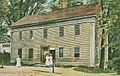
Frary House c. 1905
-
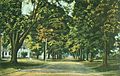
Old Main Street c. 1910
-
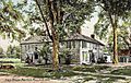
Post Office c. 1910
-
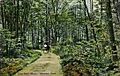
Mountain Road c. 1910


| Wikisource has the text of the 1920 Encyclopedia Americana article Deerfield. |
Education
Deerfield is the central member of Frontier Regional and Union 38 School Districts, which also includes Conway, Whately, and Sunderland. Each town operates its own elementary school, with Deerfield Elementary School serving the town's students from kindergarten through sixth grades. All four towns send seventh through twelfth grade students to Frontier Regional School in the town. Frontier's athletics teams are nicknamed the Red Hawks, and the team colors are red and blue. There are many art programs available during and after school at Frontier. Private schools in the town include the Bement School (a coeducational boarding school for grades K–9), the Eaglebrook School (a private boys' boarding school for grades 6–9), and Deerfield Academy, a private school for grades 9–12. There are other private schools in the Deerfield area.
The nearest community college, Greenfield Community College, is located in Greenfield. The nearest state college is Massachusetts College of Liberal Arts in North Adams and the nearest state universities are the University of Massachusetts Amherst and Westfield State University. The nearest private colleges are Amherst College, Hampshire College, Mount Holyoke College, and Smith College.
Notable people
- Frank Boyden (1879–1972), Headmaster of Deerfield Academy
- Alon Bement (1876–1954), an American artist, arts administrator, author, and educator, whose family helped found Deerfield
- Francis John Higginson (1843–1931), rear admiral in U.S. Navy, raised in Deerfield
- George Sheldon (preservationist) (1818–1916), Deerfield town historian and justice of the peace
- Jennie Maria Arms Sheldon (1852–1938), curator of Deerfield's Memorial Hall Museum
- Lucy Terry (c. 1730–1821), African-American poet
- John Williams (1817–1899), Episcopal bishop, born in Deerfield
See also
 In Spanish: Deerfield (Massachusetts) para niños
