
Delano, Wichita, Kansas facts for kids
Quick facts for kids
Delano
|
|
|---|---|

The Delano Clock Tower (2012)
|
|
| Country | United States |
| State | Kansas |
| County | Sedgwick |
| City | Wichita |
| Platted | 18?? (Elgin) 1871 (Delano) 1880 (West Wichita) |
| Elevation | 1,299 ft (396 m) |
| Population
(2016)
|
|
| • Total | 5,479 |
| Demonym(s) | Delanonians |
| ZIP code |
67203, 67213
|
| Area code | 316 |
Delano is a neighborhood located in Wichita, Kansas, United States. A mixed commercial and residential area on the west bank of the Arkansas River, it is home to Friends University, Riverfront Stadium, and Exploration Place, the Sedgwick County science museum.
Contents
History
Thanks to the availability of cheap land under the Homestead Act of 1862, settlers purchased land across the Arkansas River from Wichita, Kansas. These settlers named their new community Elgin. In 1870, Elgin became a cattle shipment point on the Chisholm Trail and began to grow. In March 1871, local residents renamed the town Delano after Columbus Delano, Secretary of the Interior under President Ulysses S. Grant. Hotels, saloons, and other new businesses opened over the next two years along with a post office and a toll bridge across the river to Wichita. Unlike Wichita, Delano had no law enforcement. As a result, it became an area center of drinking and gambling for cowboys working in the cattle trade. Gunfights occurred as well. In the late 1870s, the cattle trade relocated west to Dodge City, and Delano’s period as a rowdy cowtown ended.
Wichita annexed Delano in 1880, and it became locally known as West Wichita. An economic boom a few years later triggered residential development. Streets in the neighborhood were named after prominent settlers. New businesses opened as well, including a watch factory. Garfield University, later repurposed as Friends University, opened in Delano in 1887. By the end of the decade, however, the city had entered an economic recession, and many locals went bankrupt.
Development returned in the early 1900s with renewed growth in manufacturing and the oil industry. In the 1920s, Wichita became a center of aircraft manufacturing, and several companies opened facilities in Delano. These included Travel Air in 1925 and Cessna in 1927 as well as smaller companies such as the Wichita Blue Streak Motor Company, Hilton Aircraft, and Yunker Aircraft Company. By the 1930s, the majority of Delano consisted of modest residential property built during the preceding three decades.
In the early 1930s, the Ackerman Island sandbar located in the middle of the Arkansas River was moved westward to become the west bank of the current river. The former baseball stadium on Ackerman Island was razed, so a new baseball field was built, Lawrence Athletic Field, later Lawrence–Dumont Stadium, which opened in Delano in 1934. That same year, the city government had the Ben F. McLean Memorial Fountain built in the neighborhood to commemorate McLean, a former mayor.
In the 1950s and 60s, businesses and retailers began to leave the neighborhood. The aircraft industry relocated elsewhere in the city. By the 1990s, the area had entered a period of modest decline. In 1999 and 2000, neighborhood organizations and the city government collaborated to develop and implement a revitalization plan, including infrastructure investment and new business development. Since, Delano’s business district has become a local shopping and entertainment area marketed as the Historic Delano District.
Geography
Delano is located at 37°40′58″N 97°21′35″W / 37.68278°N 97.35972°W (37.682778, -97.359722) at an elevation of 1,299 feet (396 m). The Arkansas River forms its northern and eastern boundary, U.S. Route 54 its southern boundary, and Meridian Avenue its western boundary. Located across the river west from Downtown Wichita, Delano borders the neighborhoods of McCormick to the south and Sunflower to the west. Riverside lies across the river to the north.
Parks and recreation
- Delano Park
- Seneca Park
- West Side Athletic Field
Culture
Points of interest
- Exploration Place
- Lawrence–Dumont Stadium
- Wichita Ice Center
- Delano Clock Tower
- Historic Photos: Delano area, wichitaphotos.org
Education
Primary and secondary education
Wichita Public Schools operates two facilities in Delano: Allison Traditional Magnet Middle School and Franklin Elementary School.
The Roman Catholic Diocese of Wichita oversees one Catholic elementary school in the neighborhood, St. Joseph School.
Northfield School of the Liberal Arts is located in Delano. It teaches sixth through twelfth grades.
Colleges and universities
The main campus of Friends University, a private, non-denominational Christian university, is located in Delano.
Libraries
The Advanced Learning Library, the central facility of the Wichita Public Library, is located on West Second Street in Delano.
Transportation
Douglas Avenue is the primary east-west street through Delano; Seneca is the primary north-south street. Other arterial roads include: Maple Street, which runs east-west a few blocks south of Douglas; Meridian Avenue, which runs north-south along the western edge of the neighborhood; and McLean Boulevard, which runs along the west bank of the Arkansas River. U.S. Route 54 runs east-west along the southern edge of the neighborhood as the Kellogg Avenue freeway, accessible via interchanges at Sycamore Street, Seneca, and Meridian.
Several Wichita Transit bus routes service Delano including the 11, 12, 14, and 15 routes. The Delano/Old Town and Douglas routes of the free Q-Line trolley also service the neighborhood.
Kansas and Oklahoma Railroad operates a freight rail line which enters Delano from the northwest and exits to the southwest.
Images for kids
-

Exploration Place science museum (2013)
-
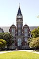
University Hall at Friends University (2012)
-
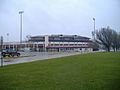
Lawrence-Dumont Stadium (2009)
-
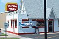
The original Nu Way Cafe (2007)


_in_Wichita,_Kansas.jpg)
