
Delaware River facts for kids
Quick facts for kids Delaware River |
|
|---|---|
.jpg)
Delaware River at New Hope, Pennsylvania
|
|

Map of the Delaware River watershed, showing major tributaries and cities
|
|
| Country | United States |
| State | New York, New Jersey, Pennsylvania, Delaware and Maryland |
| Cities | Margaretville, NY, Delhi, NY, Deposit, NY, Hancock, NY, Callicoon, NY, Lackawaxen, PA, Port Jervis, NY, Stroudsburg, PA, Easton, PA, New Hope, PA, Trenton, NJ, Camden, NJ, Philadelphia, PA, Chester, PA, Wilmington, DE , Salem, NJ, Dover, DE |
| Physical characteristics | |
| Main source | West Branch Mount Jefferson, Town of Jefferson, Schoharie County, New York, United States 2,240 ft (680 m) 42°27′12″N 74°36′26″W / 42.45333°N 74.60722°W |
| 2nd source | East Branch Grand Gorge, Town of Roxbury, Delaware County, New York, United States 1,560 ft (480 m) 42°21′26″N 74°30′42″W / 42.35722°N 74.51167°W |
| River mouth | Delaware Bay Delaware, United States 0 ft (0 m) 39°25′13″N 75°31′11″W / 39.42028°N 75.51972°W |
| Length | 301 mi (484 km) |
| Discharge (location 2) |
|
| Basin features | |
| Basin size | 13,539 sq mi (35,070 km2) |
| Tributaries | |
| Type: | Scenic, Recreational |
The Delaware River is a major river on the Atlantic coast of the United States. It drains an area of 13,539 square miles (35,070 km2) in four U.S. states: Delaware, New Jersey, New York and Pennsylvania. Rising in two branches in New York state's Catskill Mountains, the river flows 419 miles (674 km) into Delaware Bay where its waters enter the Atlantic Ocean near Cape May in New Jersey and Cape Henlopen in Delaware. Not including Delaware Bay, the river's length including its two branches is 388 miles (624 km). The Delaware River is one of nineteen "Great Waters" recognized by the America's Great Waters Coalition.
The Delaware River rises in two main branches that descend from the western flank of the Catskill Mountains in New York. The West Branch begins near Mount Jefferson in the Town of Jefferson in Schoharie County. The river's East Branch begins at Grand Gorge in Delaware County. These two branches flow west and merge near Hancock in Delaware County, and the combined waters flow as the Delaware River south. Through its course, the Delaware River forms the boundaries between Pennsylvania and New York, the entire boundary between New Jersey and Pennsylvania, and most of the boundary between Delaware and New Jersey. The river meets tide-water at the junction of Morrisville, Pennsylvania, and Trenton, New Jersey, at the Falls of the Delaware. The river's navigable, tidal section served as a conduit for shipping and transportation that aided the development of the industrial cities of Trenton, Camden and Philadelphia.
Before the arrival of European settlers, the river was the homeland of the Lenape Native Americans. They called the river Lenapewihittuk, or Lenape River, and Kithanne, meaning the largest river in this part of the country.
In 1609 the river was visited by a Dutch East India Company expedition led by Henry Hudson. Hudson, an English navigator, was hired to find a western route to Cathay (present-day China), but his discoveries set the stage for Dutch colonization of North America in the 17th century. Early Dutch and Swedish settlements were established along the lower section of the river and Delaware Bay. Both colonial powers called the river the South River, compared to the Hudson River, which was known as the North River. After the English expelled the Dutch and took control of the New Netherland colony in 1664, the river was renamed Delaware after Sir Thomas West, 3rd Baron De La Warr, an English nobleman and the Virginia colony's first royal governor who defended the colony during the First Anglo-Powhatan War.
Origin of the name

The Delaware River is named in honor of Thomas West, 3rd Baron De La Warr (1577–1618), an English nobleman and the Virginia colony's first royal governor who defended the colony during the First Anglo-Powhatan War. Lord de la Warr waged a punitive campaign to subdue the Powhatan after they had killed the colony's council president, John Ratcliffe, and attacked the colony's fledgling settlements. Lord de la Warr arrived with 150 soldiers in time to prevent colony's original settlers at Jamestown from giving up and returning to England and is credited with saving the Virginia colony. The name of barony (later an earldom) is pronounced as in the current spelling form "Delaware" ( DEL-ə-wair) and is thought to derive from French de la Guerre.
It has often been reported that the river and bay received the name "Delaware" after English forces under Richard Nicolls expelled the Dutch and took control of the New Netherland colony in 1664. However, the river and bay were known by the name Delaware as early as 1641. The state of Delaware was originally part of the William Penn's Pennsylvania colony. In 1682, the Duke of York granted Penn's request for access to the sea and leased him the territory along the western shore of Delaware Bay which became known as the "Lower Counties on the Delaware." In 1704, these three lower counties were given political autonomy to form a separate provincial assembly, but shared its provincial governor with Pennsylvania until the two colonies separated on June 15, 1776 and remained separate as states after the establishment of the United States. The name also became used as a collective name for the Lenape, a Native American people (and their language) who inhabited an area of the basins of the Susquehanna River, Delaware River, and lower Hudson River in the northeastern United States at the time of European settlement. As a result of disruption following the French & Indian War, American Revolutionary War and later Indian removals from the eastern United States, the name "Delaware" has been spread with the Lenape's diaspora to municipalities, counties and other geographical features in the American Midwest and Canada.
Watershed

The Delaware River's watershed drains an area of 14,119 square miles (36,570 km2) and encompasses 42 counties and 838 municipalities in five U.S. states—New York, New Jersey, Pennsylvania, Maryland, and Delaware. This total area constitutes approximately 0.4% of the land mass in the United States. In 2001, the watershed was 18% agricultural land, 14% developed land, and 68% forested land.
There are 216 tributary streams and creeks—an estimated 14,057 miles of streams and creeks—in the watershed. While the watershed is home to 4.17 million people according to the 2000 Federal Census, these bodies of water provide drinking water to 17 million people—roughly 6% of the population of the United States. The waters of the Delaware River's basin are used to sustain "fishing, transportation, power, cooling, recreation, and other industrial and residential purposes." It is the 33rd largest river in the United States in terms of flow, but the nation's most heavily used rivers in daily volume of tonnage. The average annual flow rate of the Delaware is 11,700 cubic feet per second at Trenton, New Jersey. With no dams or impediments on the river's main stem, the Delaware is one of the few remaining large free-flowing rivers in the United States.
Course
West Branch of the Delaware

The West Branch of the Delaware River (also called the Mohawk Branch) spans approximately 90 miles (140 km) from the northern Catskill Mountains to where it joins in confluence with the Delaware River's East Branch at Hancock, New York. The last 6 miles (9.7 km) forms part of the boundary between New York and Pennsylvania.
The West Branch rises in Schoharie County, New York at 1,886 feet (575 m) above sea level, near Mount Jefferson, and flows tortuously through the plateau in a deep trough. The branch flows generally southwest, entering Delaware County and flowing through the towns of Stamford and Delhi. In southwestern Delaware County it flows in an increasingly winding course through the mountains, generally southwest. At Stilesville the West Branch was impounded in the 1960s to form the Cannonsville Reservoir, the westernmost of the reservoirs in the New York City water system. It is the most recently constructed New York City reservoir and began serving the city in 1964. Draining a large watershed of 455 square miles (1,180 km2), the reservoir's capacity is 95.7 billion US gallons (362,000,000 m3). This water flows over halfway through the reservoir to enter the 44-mile (71 km) West Delaware Tunnel in Tompkins, New York. Then it flows through the aqueduct into the Rondout Reservoir, where the water enters the 85 miles (137 km) Delaware Aqueduct, that contributes to roughly 50% of the city's drinking water supply. At Deposit, on the border between Broome and Delaware counties, it turns sharply to the southeast and is paralleled by New York State Route 17. It joins the East Branch at 880 feet (270 m) above sea level at Hancock to form the Delaware.
East Branch of the Delaware

Similarly, the East Branch begins from a small pond south of Grand Gorge in the town of Roxbury in Delaware County, flowing southwest toward its impoundment by New York City to create the Pepacton Reservoir, the largest reservoir in the New York City water supply system. Its tributaries are the Beaver Kill River and the Willowemoc Creek which enter into the river ten miles (16 km) before the West Branch meets the East Branch. The confluence of the two branches is just south of Hancock.
Both the East Branch and West Branch of the Delaware River parallel each other, both flowing in a southwesterly direction.
Upper Delaware Valley

From Hancock, New York, the river flows between the northern Pocono Mountains in Pennsylvania, and the lowered shale beds north of the Catskills. The river flows down a broad Appalachian valley, passing Hawk's Nest overlook on the Upper Delaware Scenic Byway. The river flows southeast for 78 miles through rural regions along the New York-Pennsylvania border to Port Jervis and the Shawangunk Mountains.
The Minisink
At Port Jervis, New York, it enters the Port Jervis trough. At this point, the Walpack Ridge deflects the Delaware into the Minisink Valley, where it follows the southwest strike of the eroded Marcellus Formation beds along the Pennsylvania–New Jersey state line for 25 miles (40 km) to the end of the ridge at Walpack Bend in the Delaware Water Gap National Recreation Area. The Minisink is a buried valley where the Delaware flows in a bed of glacial till that buried the eroded bedrock during the last glacial period. It then skirts the Kittatinny ridge, which it crosses at the Delaware Water Gap, between nearly vertical walls of sandstone, quartzite, and conglomerate, and then passes through a quiet and charming country of farm and forest, diversified with plateaus and escarpments, until it crosses the Appalachian plain and enters the hills again at Easton, Pennsylvania. From this point it is flanked at intervals by fine hills, and in places by cliffs, of which the finest are the Nockamixon Rocks, 3 miles (5 km) long and above 200 feet (61 m) high.
The Appalachian Trail, which traverses the ridge of Kittatinny Mountain in New Jersey, and Blue Mountain in Pennsylvania, crosses the Delaware River at the Delaware Water Gap near Columbia, New Jersey.
Central Delaware Valley

At Easton, Pennsylvania, the Lehigh River enters the Delaware. At Trenton there is a fall of 8 feet (2.4 m).
The Lower Delaware and Tide-Water

Below Trenton the river flows between Philadelphia and New Jersey before becoming a broad, sluggish inlet of the sea, with many marshes along its side, widening steadily into its great estuary, Delaware Bay.
The Delaware River constitutes the boundary between Delaware and New Jersey. The Delaware-New Jersey border is actually at the easternmost river shoreline within the Twelve-Mile Circle of New Castle, rather than mid-river or mid-channel borders, causing small portions of land lying west of the shoreline, but on the New Jersey side of the river, to fall under the jurisdiction of Delaware. The rest of the borders follow a mid-channel approach.
History

The Delaware River played a key factor in the economic and social development of the Mid-Atlantic region. In the seventeenth century it provided the conduit for colonial settlement by the Dutch (New Netherland), the Swedish (New Sweden). Beginning in 1664, the region became an English possession as settlement by Quakers established the colonies of Pennsylvania (including present-day Delaware) and West Jersey. In the eighteenth century, cities like Philadelphia, Camden (then Cooper's Ferry), Trenton, and Wilmington, and New Castle were established upon the Delaware and their continued commercial success into the present day has been dependent on access to the river for trade and power. The river provided the path for the settlement of northeastern Pennsylvania's Lehigh Valley, and northwestern New Jersey by German Palatine immigrants—a population that became key in the agricultural development of the region.
Washington's crossing of the Delaware

Perhaps the most famous "Delaware Crossing" involved the improvised boat crossing undertaken by George Washington's army during the American Revolution on the night of December 25–26, 1776. This led to a successful surprise attack on the Hessian troops occupying Trenton, New Jersey.
Canals

The magnitude of the commerce of Philadelphia has made the improvements of the river below that port of great importance. Small improvements were attempted by Pennsylvania as early as 1771. Commerce was once important on the upper river, primarily prior to railway competition (1857).
- The Delaware Division of the Pennsylvania Canal, running parallel with the river from Easton to Bristol, opened in 1830.
- The Delaware and Raritan Canal, which runs along the New Jersey side of the Delaware River from Bulls Island, New Jersey to Trenton, unites the waters of the Delaware and Raritan rivers as it empties the waters of the Delaware River via the canal outlet in New Brunswick. This canal water conduit is still used as a water supply source by the State of New Jersey.
- The Morris Canal (now abandoned and almost completely filled in) and the Delaware and Hudson Canal connected the Delaware and Hudson rivers.
- The Chesapeake and Delaware Canal joins the waters of the Delaware with those of the Chesapeake Bay.
In the "project of 1885" the U.S. government undertook systematically the formation of a 26-foot (7.9 m) channel 600 feet (180 m) wide from Philadelphia to deep water in Delaware Bay. The River and Harbor Act of 1899 provided for a 30-foot (9.1 m) channel 600 feet (180 m) wide from Philadelphia to the deep water of the bay.
Delaware Water Gap National Recreation Area

The Delaware Water Gap National Recreation Area came about as a result of the failure of a controversial plan to build a dam on the Delaware River at Tocks Island, just north of the Delaware Water Gap to control water levels for flood control and hydroelectric power generation. The dam would have created a 37-mile (60 km) lake in the center of present park for use as a reservoir. Starting in 1960, the present day area of the Recreation Area was acquired for the Army Corps of Engineers through eminent domain. Between 3,000 and 5,000 dwellings were demolished, including historical sites, and about 15,000 people were displaced by the project.
Because of massive environmental opposition, dwindling funds, and an unacceptable geological assessment of the dam's safety, the government transferred the property to the National Park Service in 1978. The National Park Service found itself as the caretaker of the previously endangered territory, and with the help of the federal government and surrounding communities, developed recreational facilities and worked to preserve the remaining historical structures.
Images for kids
-

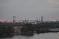
Ben Franklin Bridge crossing the Delaware and connecting Philadelphia and Camden, New Jersey
-
Walt Whitman Bridge across the Delaware, connecting Philadelphia and Gloucester City, New Jersey
-
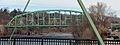
Easton-Phillipsburg Toll Bridge connecting Easton, Pennsylvania and Phillipsburg, New Jersey in the Lehigh Valley
-
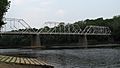
Dingman's Ferry Bridge connecting Sandyston Township, New Jersey and Delaware Township in Pike County, Pennsylvania
-
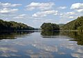
The Delaware within the southern portion of the Delaware Water Gap National Recreation Area, near Worthington State Forest in New Jersey
-
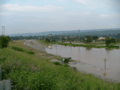
A flood in Westfall, Pennsylvania in 2006


See also
 In Spanish: Río Delaware para niños
