
Delaware Valley facts for kids
Quick facts for kids
Delaware Valley
Greater Philadelphia Southeastern Pennsylvania Philadelphia-Camden-Wilmington, PA-NJ-DE-MD MSA
|
|
|---|---|

|
|

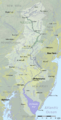
Map of the Lower Delaware Valley Metropolitan Area. In addition to the yellow-shaded area, other parts of South Jersey (namely, Atlantic County and Cape May County) and Delaware (such as Dover) are considered to be part of the Delaware Valley or Philadelphia Metropolitan Area.
|
|
| Country | |
| State | - - - - |
| Principal cities and towns | Philadelphia Camden Wilmington Atlantic City Reading Trenton Vineland Conshohocken Dover Chester Upper Darby Media Middletown Township Hammonton Norristown Doylestown Cherry Hill West Chester Evesham Washington Township Millville Salem Cape May Court House Lower Township The Wildwoods Brigantine Ventnor City Margate City Ocean City Sea Isle City Haverford Bridgeton Coatesville Lower Merion Gloucester Township Downingtown Phoenixville Pottstown King of Prussia Bensalem Township Burlington City and Burlington Township Mount Holly Newark Hamilton Township (Mays Landing) Woodbury Elkton Cheltenham Abington Township Bristol Township Mount Laurel Northampton Township Winslow Township |
| Area | |
| • Urban | 1,981.4 sq mi (5,131.7 km2) |
| • Metro | 5,118 sq mi (13,256 km2) |
| Elevation | 0 - 1,080 ft (0 - 329 m) |
| Population
(2013 est.)
|
|
| • Density | 2,746.32/sq mi (1,060.36/km2) |
| • Urban | 5,441,567 (5th) |
| • MSA | 6,096,372 (8th) |
| • CSA | 7,146,706 (8th) |
| MSA/CSA = 2013, Urban = 2010 | |
| Time zone | UTC−5 (EST) |
| • Summer (DST) | UTC−4 (EST) |
The Delaware Valley is the valley through which the Delaware River flows. By extension, this toponym is commonly used to refer to Greater Philadelphia or the Philadelphia metropolitan area. The region includes a metropolitan statistical area (MSA) and broader combined statistical area (CSA) that are composed of counties located in Southeastern Pennsylvania, South Jersey, Delaware, and the northern Eastern Shore of Maryland, including Camden, Atlantic City, and Wilmington. As of the 2010 Census, the MSA has a population of over 6 million, while the CSA has a population of over 7.1 million. 2016 Census Bureau estimates rank the Delaware Valley CSA as the ninth-largest CSA in the United States.
Philadelphia is by far the largest municipality in the Delaware Valley and serves as the region's major commercial, cultural, and industrial center. Other municipalities in the MSA include Camden, New Jersey and Wilmington, Delaware, while the larger CSA also includes municipalities such as Reading, Pennsylvania and Atlantic City, New Jersey. The Delaware Valley Metropolitan Area is located in the Northeastern United States and forms part of a larger urbanized area known as the Northeast megalopolis. According to the Bureau of Economic Analysis, the Philadelphia metropolitan area has a gross domestic product of $431 billion, the ninth-largest among U.S. metropolitan areas.
The Delaware Valley has been influential in American history and industry. The area has hosted many people and sites significant to American culture, history, and politics. Philadelphia is sometimes known as "The Birthplace of America", as both the Declaration of Independence and the Constitution were drafted and signed in Philadelphia. The Delaware Valley was home to many other instrumental moments in the American Revolution, and Philadelphia served as the capital of the United States for much of the 18th century. Today, the area is home to a number of nationally known universities, such as the University of Pennsylvania, Drexel University, Villanova University, Saint Joseph's University, Temple University, Rutgers University-Camden, La Salle University and University of Delaware.
Contents
Geography
In geology and geography, a strict sense of the term would incorporate the Delaware River's main drainage basin, and so encompass major tributaries such as the Schuylkill River and Lehigh River and their valleys or sub-basins. These extensions also apply culturally with decreasing degree gradually decreased by proximal distance because the ease of land travel enables a great deal of daily interaction; for example, the large number of commuters who travel daily 45–90 minutes creates cultural blends and parallel values.

Population and economy

According to 2016 estimates from the United States Census Bureau, the Philadelphia-Camden-Wilmington Metropolitan Statistical Area ranks as the seventh-largest MSA in the United States with 6,070,500 people. According to the Bureau of Economic Analysis, the Philadelphia-Camden-Wilmington MSA had a gross domestic product of $431 billion, the ninth-largest among U.S. metropolitan areas. 2016 Census Bureau estimates rank the Philadelphia-Reading-Camden Combined Statistical Area as the ninth-largest CSA in the United States, with 7,179,357 people.
The Philadelphia-Camden-Wilmington Metropolitan Statistical Area's population of roughly 6 million people is comparable to that of countries such as Lebanon, Denmark, and Nicaragua. The MSA's nominal gross domestic product of $431 billion is comparable to countries such as Belgium, Iran, and Thailand. The MSA also ranks as the second most populous in the Northeastern United States after the New York metropolitan area, while the CSA is third-largest in the Northeast after the New York and Boston metropolitan areas. The Baltimore–Washington metropolitan area, which is part of Northeast Megalopolis but is considered part of the Southeastern United States under Census Bureau definitions, is also larger than the Philadelphia metropolitan area. Philadelphia itself is the sixth-most populous city in the United States and the third-most populous U.S. city east of the Mississippi River, after New York City and Chicago. Philadelphia's media market ranks fourth, behind New York City, Los Angeles, and Chicago, in Nielsen Media Market size rankings.
Such educational institutions as Delaware Valley Regional High School in Alexandria Township and Delaware Valley College in Doylestown Township are named after the region. Likewise, Frenchtown's now defunct newspaper The Delaware Valley News was another example of the usage.
Subregions
Sixteen counties in four states constitute the Philadelphia-Reading-Camden Combined Statistical Area. The five Pennsylvania counties in the MSA are collectively known as Southeastern Pennsylvania, and the four suburban counties from this region are sometimes called the "collar counties." Aside from Philadelphia, major municipalities in Southeastern Pennsylvania include the inner suburbs of Upper Darby Township and Bensalem Township. Berks County, which forms its own MSA and contains the CSA's second largest city, Reading, is generally not considered to be part of Southeastern Pennsylvania and is sometimes assigned to South Central Pennsylvania.
The seven New Jersey counties in the CSA form South Jersey, although Ocean County, which is part of the New York CSA, is also sometimes considered to be part of South Jersey. Atlantic County, Cape May County, and Cumberland County each form their own respective metropolitan statistical areas. Atlantic City, Cape May County, and the southern Jersey Shore (including Margate City, Ventnor City, the Wildwoods, and Sea Isle City) are major tourist destinations for people from inside and outside of the Delaware Valley. Other major municipalities in South Jersey include Cherry Hill and Camden, which is across the Delaware River from Philadelphia.
The two counties of Delaware in the CSA constitute a majority of Delaware's land mass and population. Wilmington is the most populous city in Delaware and the fifth-most populous municipality in the Delaware Valley. The lone Maryland county in the Philadelphia-Reading-Camden Combined Statistical Area is part of the region known as the Eastern Shore of Maryland.
Although Mercer County in Central Jersey is often considered part of the Delaware Valley from a cultural perspective, it is classified as part of New York's CSA by the OMB. Mercer County and three counties in Pennsylvania's Lehigh Valley, Carbon County, Lehigh County and Northampton County, are part of the Philadelphia media market. Caroline County, Maryland is also part of the Philadelphia media market, and other counties within the Philadelphia media market include Monroe County, Pennsylvania, Lancaster County, Pennsylvania, and Ocean County, New Jersey.
List of counties
| County | State | Seat | 2010 Pop. | 2016 Pop. | Pop. Change | Area | MSA | Map |
|---|---|---|---|---|---|---|---|---|
| Kent | DE | Dover | 162,310 | 174,827 | 7.7% | 279.4 mi2 | Dover MSA | |
| New Castle | DE | Wilmington | 538,479 | 556,987 | 3.4% | 426.3 mi2 | Philadelphia–Camden–Wilmington MSA | |
| Cecil | MD | Elkton | 101,108 | 102,603 | 1.5% | 348.2 mi2 | Philadelphia–Camden–Wilmington MSA | |
| Atlantic | NJ | Mays Landing | 274,549 | 270,991 | -1.3% | 561.2 mi2 | Atlantic City-Hammonton MSA | |
| Burlington | NJ | Mount Holly | 448,734 | 449,284 | 0.1% | 804.8 mi2 | Philadelphia–Camden–Wilmington MSA | |
| Camden | NJ | Camden | 513,657 | 510,150 | -0.7% | 222.3 mi2 | Philadelphia–Camden–Wilmington MSA | |
| Cape May | NJ | Cape May Court House | 97,265 | 94,430 | -2.9% | 255.2 mi2 | Ocean City MSA | |
| Cumberland | NJ | Bridgeton | 156,898 | 153,797 | -2% | 489.3 mi2 | Vineland-Millville-Bridgeton MSA | |
| Gloucester | NJ | Woodbury | 288,288 | 292,330 | 1.4% | 324.9 mi2 | Philadelphia–Camden–Wilmington MSA | |
| Salem | NJ | Salem | 66,083 | 63,436 | -4% | 337.8 mi2 | Philadelphia–Camden–Wilmington MSA | |
| Berks | PA | Reading | 411,442 | 414,812 | 0.8% | 859.2 mi2 | Reading MSA | |
| Bucks | PA | Doylestown | 625,249 | 626,399 | 0.2% | 607.6 mi2 | Philadelphia–Camden–Wilmington MSA | |
| Chester | PA | West Chester | 498,886 | 516,312 | 3.5% | 756 mi2 | Philadelphia–Camden–Wilmington MSA | |
| Delaware | PA | Media | 558,979 | 563,402 | 0.8% | 184.2 mi2 | Philadelphia–Camden–Wilmington MSA | |
| Montgomery | PA | Norristown | 799,874 | 821,725 | 2.7% | 487 mi2 | Philadelphia–Camden–Wilmington MSA | |
| Philadelphia | PA | Philadelphia | 1,526,006 | 1,576,872 | 3.3% | 135.1 mi2 | Philadelphia–Camden–Wilmington MSA | |
| Philadelphia–Camden–Wilmington MSA | 5,965,343 | 6,079,500 | 1.8% | 4928.2 mi2 | Philadelphia–Camden–Wilmington MSA | - | ||
| Philadelphia–Reading–Camden CSA | 7,067,807 | 7,179,357 | 1.6% | 7372.5 mi2 | N/A | - | ||
List of largest municipalities


These municipalities are all within the Philadelphia-Reading-Camden Combined Statistical Area.
| City | Pop. | County | State |
|---|---|---|---|
| Philadelphia | 1,567,872 | Philadelphia | PA |
| Reading | 87,575 | Berks | PA |
| Upper Darby Township | 82,765 | Delaware | PA |
| Camden | 74,420 | Camden | NJ |
| Wilmington | 71,502 | New Castle | DE |
| Cherry Hill | 70,976 | Camden | NJ |
| Gloucester Township | 64,049 | Camden | NJ |
| Vineland | 60,876 | Cumberland | NJ |
| Bensalem Township | 60,354 | Bucks | PA |
| Lower Merion Township | 58,220 | Montgomery | PA |
| Abington Township | 55,640 | Montgomery | PA |
| Bristol Township | 54,170 | Bucks | PA |
| Haverford Township | 48,893 | Delaware | PA |
| Washington Township | 48,301 | Gloucester | NJ |
| Evesham Township | 45,578 | Burlington | NJ |
| Middletown Township | 45,318 | Bucks | PA |
| Egg Harbor Township | 43,747 | Atlantic | NJ |
| Mount Laurel | 41,849 | Burlington | NJ |
| Northampton Township | 39,562 | Bucks | PA |
| Winslow Township | 39,417 | Camden | NJ |
Statistical history
When metropolitan areas were originally defined in 1950, most of the area now in the Delaware Valley was split between four metropolitan areas, or "standard metropolitan areas," as they were called. The Philadelphia SMA comprised Philadelphia, Bucks, Chester, Delaware and Montgomery counties in Pennsylvania and Burlington, Camden and Gloucester counties in New Jersey. The Wilmington SMA comprised New Castle County in Delaware and Salem County in New Jersey, while Berks County was the Reading SMA and Atlantic County was the Atlantic City SMA.
In 1960, Cecil County was added to what was now the Wilmington Standard Metropolitan Statistical Area. In 1980, Cumberland County was defined as the Vineland-Millville-Bridgeton SMSA.
In 1990, the Philadelphia, Wilmington and Vineland-Millville-Bridgeton SMSAs were merged with the Trenton SMSA as the Philadelphia-Wilmington-Trenton Consolidated Metropolitan Statistical Area. At the same time, Cape May County was added to the Atlantic City SMSA. "Philadelphia-Wilmington-Trenton" became obsolete one census later, with Trenton moving to the New York-Newark-Bridgeport CSA, and the Philadelphia-Wilmington-Vineland CSA consisting only of the Philadelphia-Wilmington-Camden MSA and the Vineland-Millville-Bridgeton MSA. Kent County became the Dover MSA in 2000, and it and Atlantic City were added to the Philadelphia CSA in 2010, for a total of six MSA components; as a result of new 2010 definitions based on a threshold of 15% labor interchange between MSAs, two more MSAs were added to the CSA, for a total of six. With Ocean City, NJ, and Reading, PA, the CSA is now known as Philadelphia-Reading-Camden.
Characteristics


The Delaware Valley is home to extensive populations of Irish Americans, German Americans, English Americans, Ukrainian Americans, Italian Americans, Swedish-Americans (which have a museum located at FDR Park in South Philadelphia), Polish Americans, Scottish Americans, Ulster Scot or "Scotch-Irish" Americans, Welsh Americans, Jewish Americans, Greek Americans, African Americans, Chinese Americans, Indian Americans, Russian Americans, Korean Americans, Vietnamese Americans, Armenian Americans, Arab Americans, Turkish Americans, Pakistani Americans, Israeli Americans, various African immigrant groups, particularly from West African; various West Indian American groups, including Jamaican Americans; and Hispanic Americans. Within the Hispanic population, the vast majority are Puerto Ricans, though other significant groups include Dominican Americans and Mexican Americans, as well as significant populations from Central America. There is even a small Native American community known as Lenapehoking for Lenni-Lenape Indians of West Philadelphia.
Philadelphia's suburbs contain a high concentration of malls, the two largest of which have at least 5,000,000 square feet (460,000 m2) of office space, and at least 600,000 square feet (56,000 m2) of retail. These are the King of Prussia mall in King of Prussia, Pennsylvania, which is the largest in the United States (leasable sq. feet of retail space), and the Cherry Hill Mall in Cherry Hill, New Jersey, which was the first enclosed mall on the East Coast. Malls, office complexes, strip shopping plazas, expressways, and tract housing are common sights, and more and more continue to replace rolling countryside, farms, woods, and wetlands. However, due to strong opposition by residents and political officials, many acres of land have been preserved throughout the Delaware Valley. Older townships and large boroughs such as Cheltenham, Norristown, Jenkintown, Upper Darby and West Chester retain distinct community identities while engulfed in suburbia. The fastest-growing counties are Chester, Montgomery, Bucks, and Gloucester. Upper Darby, in Delaware County is the largest township in the United States. Sometimes Reading is included in the Delaware Valley Metro Area.
Mid-Atlantic American English and its subset, Philadelphia English, are two common dialects of American English in Philadelphia and the Delaware Valley.
Climate
The Delaware Valley has four distinct seasons with ample precipitation and is divided by the 0 °C (32 °F) January isotherm. Most of Philadelphia and the NJ portion, almost all of the DE and MD portions, part of Delaware County, and extreme southern portions of Bucks and Chester Counties have a humid subtropical climate (Cfa.) The remainder of the Delaware Valley has a hot-summer humid continental climate (Dfa.) Snow amounts may vary widely year-to-year and normally do vary widely within the Delaware Valley. The region has only two ski areas: Bear Creek Ski and Recreation Area in eastern Berks County and Spring Mountain in central Montgomery County.
Using the -3 °C January isotherm as a boundary, all of the Delaware Valley is humid subtropical except for portions of Berks County and higher areas of northern Chester County. The warm-summer humid continental climate (Dfb) only exists in higher areas of Berks where all monthly temperatures average below 22 °C.
| Climate data for Philadelphia (Philadelphia Airport), 1981–2010 normals, extremes 1872–present | |||||||||||||
|---|---|---|---|---|---|---|---|---|---|---|---|---|---|
| Month | Jan | Feb | Mar | Apr | May | Jun | Jul | Aug | Sep | Oct | Nov | Dec | Year |
| Record high °F (°C) | 74 (23) |
79 (26) |
87 (31) |
95 (35) |
97 (36) |
102 (39) |
104 (40) |
106 (41) |
102 (39) |
96 (36) |
84 (29) |
73 (23) |
106 (41) |
| Mean maximum °F (°C) | 62.0 (16.7) |
62.7 (17.1) |
73.6 (23.1) |
83.2 (28.4) |
89.1 (31.7) |
94.2 (34.6) |
96.4 (35.8) |
94.7 (34.8) |
89.8 (32.1) |
81.7 (27.6) |
72.3 (22.4) |
63.5 (17.5) |
97.5 (36.4) |
| Average high °F (°C) | 40.3 (4.6) |
43.8 (6.6) |
52.7 (11.5) |
63.9 (17.7) |
73.8 (23.2) |
82.7 (28.2) |
87.1 (30.6) |
85.3 (29.6) |
78.0 (25.6) |
66.6 (19.2) |
56.0 (13.3) |
44.8 (7.1) |
64.6 (18.1) |
| Daily mean °F (°C) | 33.0 (0.6) |
35.7 (2.1) |
43.5 (6.4) |
54.0 (12.2) |
63.9 (17.7) |
73.3 (22.9) |
78.1 (25.6) |
76.6 (24.8) |
69.1 (20.6) |
57.5 (14.2) |
47.6 (8.7) |
37.5 (3.1) |
55.9 (13.3) |
| Average low °F (°C) | 25.6 (−3.6) |
27.7 (−2.4) |
34.4 (1.3) |
44.1 (6.7) |
54.0 (12.2) |
63.8 (17.7) |
69.2 (20.7) |
67.9 (19.9) |
60.3 (15.7) |
48.4 (9.1) |
39.2 (4.0) |
30.1 (−1.1) |
47.1 (8.4) |
| Mean minimum °F (°C) | 8.7 (−12.9) |
12.7 (−10.7) |
19.4 (−7.0) |
31.6 (−0.2) |
42.0 (5.6) |
52.2 (11.2) |
59.8 (15.4) |
57.8 (14.3) |
47.2 (8.4) |
35.8 (2.1) |
26.0 (−3.3) |
15.8 (−9.0) |
6.4 (−14.2) |
| Record low °F (°C) | −7 (−22) |
−11 (−24) |
5 (−15) |
14 (−10) |
28 (−2) |
44 (7) |
51 (11) |
44 (7) |
35 (2) |
25 (−4) |
8 (−13) |
−5 (−21) |
−11 (−24) |
| Average precipitation inches (mm) | 3.03 (77) |
2.65 (67) |
3.79 (96) |
3.56 (90) |
3.71 (94) |
3.43 (87) |
4.35 (110) |
3.50 (89) |
3.78 (96) |
3.18 (81) |
2.99 (76) |
3.56 (90) |
41.53 (1,055) |
| Average snowfall inches (cm) | 6.5 (17) |
8.8 (22) |
2.9 (7.4) |
0.5 (1.3) |
0 (0) |
0 (0) |
0 (0) |
0 (0) |
0 (0) |
0 (0) |
0.3 (0.76) |
3.4 (8.6) |
22.4 (57) |
| Average precipitation days (≥ 0.01 in) | 10.6 | 9.4 | 10.5 | 11.3 | 11.1 | 9.8 | 9.9 | 8.4 | 8.7 | 8.6 | 9.3 | 10.6 | 118.2 |
| Average snowy days (≥ 0.1 in) | 4.4 | 3.6 | 1.8 | 0.4 | 0 | 0 | 0 | 0 | 0 | 0 | 0.2 | 1.8 | 12.2 |
| Average relative humidity (%) | 66.2 | 63.6 | 61.7 | 60.4 | 65.4 | 67.8 | 69.6 | 70.4 | 71.6 | 70.8 | 68.4 | 67.7 | 67.0 |
| Mean monthly sunshine hours | 155.7 | 154.7 | 202.8 | 217.0 | 245.1 | 271.2 | 275.6 | 260.1 | 219.3 | 204.5 | 154.7 | 137.7 | 2,498.4 |
| Percent possible sunshine | 52 | 52 | 55 | 55 | 55 | 61 | 61 | 61 | 59 | 59 | 52 | 47 | 56 |
| Source: NOAA (relative humidity and sun 1961–1990) | |||||||||||||
| Climate data for Atlantic City, New Jersey (downtown), 1981–2010 normals, extremes 1874–present | |||||||||||||
|---|---|---|---|---|---|---|---|---|---|---|---|---|---|
| Month | Jan | Feb | Mar | Apr | May | Jun | Jul | Aug | Sep | Oct | Nov | Dec | Year |
| Record high °F (°C) | 72 (22) |
77 (25) |
84 (29) |
91 (33) |
95 (35) |
99 (37) |
102 (39) |
104 (40) |
94 (34) |
91 (33) |
80 (27) |
74 (23) |
104 (40) |
| Mean maximum °F (°C) | 59.3 (15.2) |
59.9 (15.5) |
68.4 (20.2) |
77.3 (25.2) |
83.7 (28.7) |
89.7 (32.1) |
93.5 (34.2) |
91.8 (33.2) |
86.3 (30.2) |
78.9 (26.1) |
70.1 (21.2) |
62.4 (16.9) |
95.3 (35.2) |
| Average high °F (°C) | 41.8 (5.4) |
43.5 (6.4) |
49.6 (9.8) |
57.6 (14.2) |
66.6 (19.2) |
75.7 (24.3) |
81.3 (27.4) |
80.2 (26.8) |
74.8 (23.8) |
65.0 (18.3) |
55.8 (13.2) |
46.3 (7.9) |
61.6 (16.4) |
| Average low °F (°C) | 29.2 (−1.6) |
30.9 (−0.6) |
36.9 (2.7) |
45.5 (7.5) |
54.5 (12.5) |
64.3 (17.9) |
70.0 (21.1) |
69.7 (20.9) |
63.5 (17.5) |
52.5 (11.4) |
42.9 (6.1) |
33.5 (0.8) |
49.5 (9.7) |
| Mean minimum °F (°C) | 11.3 (−11.5) |
16.3 (−8.7) |
22.4 (−5.3) |
33.8 (1.0) |
44.3 (6.8) |
53.7 (12.1) |
61.4 (16.3) |
60.1 (15.6) |
50.5 (10.3) |
39.2 (4.0) |
29.0 (−1.7) |
19.0 (−7.2) |
10.1 (−12.2) |
| Record low °F (°C) | −4 (−20) |
−9 (−23) |
8 (−13) |
15 (−9) |
33 (1) |
45 (7) |
52 (11) |
48 (9) |
37 (3) |
27 (−3) |
10 (−12) |
−7 (−22) |
−9 (−23) |
| Average precipitation inches (mm) | 3.08 (78) |
2.87 (73) |
4.02 (102) |
3.39 (86) |
3.22 (82) |
2.68 (68) |
3.31 (84) |
3.92 (100) |
3.08 (78) |
3.47 (88) |
3.35 (85) |
3.62 (92) |
40.01 (1,016) |
| Average snowfall inches (cm) | 4.5 (11) |
6.7 (17) |
1.1 (2.8) |
0.3 (0.76) |
0 (0) |
0 (0) |
0 (0) |
0 (0) |
0 (0) |
0 (0) |
0.2 (0.51) |
3.7 (9.4) |
16.5 (42) |
| Average precipitation days (≥ 0.01 in) | 9.3 | 9.0 | 10.5 | 10.9 | 10.4 | 8.7 | 8.4 | 8.0 | 7.7 | 7.6 | 8.9 | 10.4 | 109.8 |
| Average snowy days (≥ 0.1 in) | 2.9 | 2.8 | 0.9 | 0.3 | 0 | 0 | 0 | 0 | 0 | 0 | 0.1 | 1.7 | 8.7 |
| Average relative humidity (%) | 69.5 | 69.0 | 66.9 | 66.4 | 70.7 | 72.9 | 73.9 | 75.7 | 76.4 | 74.8 | 72.8 | 70.6 | 71.6 |
| Mean monthly sunshine hours | 150.8 | 157.9 | 204.5 | 218.9 | 243.9 | 266.2 | 276.3 | 271.3 | 227.6 | 200.5 | 147.4 | 133.8 | 2,499.1 |
| Percent possible sunshine | 50 | 53 | 55 | 55 | 55 | 60 | 61 | 64 | 61 | 58 | 49 | 46 | 56 |
| Source: NOAA (relative humidity and sun 1961–1990 and snow at Atlantic City Int'l) | |||||||||||||
| Climate data for Doylestown, Pennsylvania | |||||||||||||
|---|---|---|---|---|---|---|---|---|---|---|---|---|---|
| Month | Jan | Feb | Mar | Apr | May | Jun | Jul | Aug | Sep | Oct | Nov | Dec | Year |
| Average high °F (°C) | 39 (4) |
43 (6) |
52 (11) |
63 (17) |
74 (23) |
82 (28) |
87 (31) |
85 (29) |
77 (25) |
66 (19) |
55 (13) |
44 (7) |
64 (18) |
| Average low °F (°C) | 24 (−4) |
25 (−4) |
33 (1) |
42 (6) |
52 (11) |
61 (16) |
66 (19) |
65 (18) |
57 (14) |
45 (7) |
37 (3) |
29 (−2) |
45 (7) |
| Average precipitation inches (mm) | 3.94 (100) |
2.87 (73) |
4.24 (108) |
3.85 (98) |
4.81 (122) |
3.61 (92) |
4.72 (120) |
4.34 (110) |
4.66 (118) |
3.35 (85) |
3.74 (95) |
3.80 (97) |
47.93 (1,217) |
| Source: Weather Channel | |||||||||||||
| Climate data for Reading, Pennsylvania | |||||||||||||
|---|---|---|---|---|---|---|---|---|---|---|---|---|---|
| Month | Jan | Feb | Mar | Apr | May | Jun | Jul | Aug | Sep | Oct | Nov | Dec | Year |
| Record high °F (°C) | 71 (22) |
77 (25) |
88 (31) |
97 (36) |
96 (36) |
97 (36) |
102 (39) |
102 (39) |
100 (38) |
92 (33) |
82 (28) |
77 (25) |
102 (39) |
| Average high °F (°C) | 38 (3) |
42 (6) |
51 (11) |
63 (17) |
73 (23) |
82 (28) |
86 (30) |
84 (29) |
77 (25) |
66 (19) |
54 (12) |
43 (6) |
63 (17) |
| Average low °F (°C) | 22 (−6) |
24 (−4) |
32 (0) |
41 (5) |
51 (11) |
61 (16) |
65 (18) |
64 (18) |
56 (13) |
44 (7) |
36 (2) |
27 (−3) |
44 (6) |
| Record low °F (°C) | −20 (−29) |
−8 (−22) |
−2 (−19) |
16 (−9) |
26 (−3) |
39 (4) |
46 (8) |
42 (6) |
30 (−1) |
20 (−7) |
8 (−13) |
−4 (−20) |
−20 (−29) |
| Average precipitation inches (mm) | 2.92 (74) |
2.93 (74) |
3.56 (90) |
3.69 (94) |
4.03 (102) |
4.50 (114) |
4.67 (119) |
3.80 (97) |
4.42 (112) |
3.78 (96) |
3.44 (87) |
3.58 (91) |
45.32 (1,151) |
| Source: The Weather Channel | |||||||||||||
| Climate data for Dover, Delaware (1981−2010 normals) | |||||||||||||
|---|---|---|---|---|---|---|---|---|---|---|---|---|---|
| Month | Jan | Feb | Mar | Apr | May | Jun | Jul | Aug | Sep | Oct | Nov | Dec | Year |
| Average high °F (°C) | 43.4 (6.3) |
47.0 (8.3) |
54.9 (12.7) |
65.7 (18.7) |
74.7 (23.7) |
83.2 (28.4) |
87.0 (30.6) |
85.2 (29.6) |
79.3 (26.3) |
68.8 (20.4) |
58.5 (14.7) |
47.4 (8.6) |
66.3 (19.1) |
| Average low °F (°C) | 27.1 (−2.7) |
29.0 (−1.7) |
35.6 (2.0) |
44.3 (6.8) |
53.8 (12.1) |
63.4 (17.4) |
68.4 (20.2) |
67.0 (19.4) |
60.1 (15.6) |
48.7 (9.3) |
39.8 (4.3) |
31.0 (−0.6) |
47.4 (8.6) |
| Average precipitation inches (mm) | 3.41 (87) |
3.07 (78) |
4.31 (109) |
3.88 (99) |
4.25 (108) |
4.00 (102) |
4.09 (104) |
4.36 (111) |
4.13 (105) |
3.42 (87) |
3.48 (88) |
3.65 (93) |
46.05 (1,171) |
| Average snowfall inches (cm) | 4.6 (12) |
7.7 (20) |
.3 (0.76) |
0 (0) |
0 (0) |
0 (0) |
0 (0) |
0 (0) |
0 (0) |
0 (0) |
.2 (0.51) |
2.9 (7.4) |
15.7 (40.67) |
| Average precipitation days (≥ 0.01 in) | 10.1 | 9.6 | 10.0 | 11.3 | 10.9 | 9.1 | 9.3 | 8.6 | 8.3 | 8.0 | 7.9 | 10.3 | 113.4 |
| Average snowy days (≥ 0.1 in) | 2.2 | 1.9 | .3 | 0 | 0 | 0 | 0 | 0 | 0 | 0 | 0 | .9 | 5.3 |
| Source: NOAA | |||||||||||||
| Climate data for Wilmington, Delaware (New Castle Airport), 1981–2010 normals, extremes 1894–present | |||||||||||||
|---|---|---|---|---|---|---|---|---|---|---|---|---|---|
| Month | Jan | Feb | Mar | Apr | May | Jun | Jul | Aug | Sep | Oct | Nov | Dec | Year |
| Record high °F (°C) | 75 (24) |
78 (26) |
86 (30) |
97 (36) |
98 (37) |
102 (39) |
103 (39) |
107 (42) |
100 (38) |
94 (34) |
85 (29) |
75 (24) |
107 (42) |
| Average high °F (°C) | 40.2 (4.6) |
43.5 (6.4) |
52.4 (11.3) |
63.5 (17.5) |
73.0 (22.8) |
81.8 (27.7) |
86.1 (30.1) |
84.2 (29.0) |
77.4 (25.2) |
66.2 (19.0) |
55.7 (13.2) |
44.6 (7.0) |
64.1 (17.8) |
| Average low °F (°C) | 24.6 (−4.1) |
26.8 (−2.9) |
33.6 (0.9) |
43.0 (6.1) |
52.6 (11.4) |
62.6 (17.0) |
67.6 (19.8) |
66.1 (18.9) |
58.2 (14.6) |
46.1 (7.8) |
37.4 (3.0) |
28.7 (−1.8) |
45.6 (7.6) |
| Record low °F (°C) | −14 (−26) |
−15 (−26) |
2 (−17) |
11 (−12) |
30 (−1) |
40 (4) |
48 (9) |
43 (6) |
32 (0) |
23 (−5) |
11 (−12) |
−7 (−22) |
−15 (−26) |
| Average precipitation inches (mm) | 3.01 (76) |
2.68 (68) |
3.92 (100) |
3.50 (89) |
3.95 (100) |
3.88 (99) |
4.57 (116) |
3.25 (83) |
4.32 (110) |
3.42 (87) |
3.10 (79) |
3.48 (88) |
43.08 (1,094) |
| Average snowfall inches (cm) | 5.9 (15) |
8.3 (21) |
1.9 (4.8) |
0.3 (0.76) |
0 (0) |
0 (0) |
0 (0) |
0 (0) |
0 (0) |
0 (0) |
0.4 (1.0) |
3.4 (8.6) |
20.2 (51) |
| Average precipitation days (≥ 0.01 in) | 10.5 | 9.4 | 10.7 | 11.3 | 11.2 | 10.3 | 9.9 | 8.1 | 8.5 | 8.3 | 9.2 | 10.3 | 117.7 |
| Average snowy days (≥ 0.1 in) | 4.3 | 3.6 | 1.3 | 0.4 | 0 | 0 | 0 | 0 | 0 | 0 | 0.2 | 2.0 | 11.8 |
| Source: NOAA | |||||||||||||
Colonial history
The valley was the territory of the Susquehannock and Lenape, who are recalled in place names throughout the region. The region became part of the Dutch colony of New Netherland after the exploration of Delaware Bay in 1609. The Dutch called the Delaware River the Zuyd Rivier, or South River, and considered the lands along it banks and those of its bay to be the southern flank of its province of New Netherland. In 1638, it began to be settled by Swedes, Forest Finns, Dutch, and Walloons and became the colony of New Sweden, though this was not officially recognized by the Dutch Empire which re-asserted control in 1655. The area was taken by the English in 1664. The name Delaware comes from Thomas West, 3rd Baron De La Warr, who had arrived at Jamestown, Virginia in 1610, just as original settlers were about to abandon it, and thus maintaining the English foothold on the North American continent.
Transportation
Many residents commute to jobs and travel in Philadelphia, Camden, Wilmington, and the surrounding suburbs with the help of expressways, trains, and buses. There are currently no transit connections to Reading, the second largest municipality in the region.
Rail
Rapid transit
- SEPTA
- Market–Frankford Line connecting 69th Street Transportation Center in Upper Darby to Frankford Transportation Center in Near Northeast Philadelphia, passing through Center City
- Broad Street Line connecting Fern Rock Transportation Center in North Philadelphia to Center City and NRG station in South Philadelphia
- Norristown High Speed Line connecting 69th Street Transportation Center with Norristown Transportation Center in Norristown
- PATCO
- PATCO Speedline connecting Philadelphia to Lindenwold, NJ in Camden County with connections to NJT's Atlantic City Line.
Light rail
- SEPTA
- Subway–surface lines: Routes 10, 11, 13, 34, and 36, connecting West Philadelphia and Delaware County with 13th Street Station, running at street-level through Delaware County and West Philadelphia, and beneath Market Street in Center City
- Route 15 along Girard Avenue from 63rd Street and Girard Avenue to Richmond and Westmoreland Streets
- Routes 101 and 102 connecting Media (Route 101) and Sharon Hill (Route 102) in Delaware County with 69th Street Transportation Center
- NJ Transit
- River Line connecting Camden, New Jersey to Trenton, New Jersey, running along the east bank of the Delaware River.
Commuter rail

- SEPTA Regional Rail
- Airport Line connecting Central Philadelphia with Philadelphia International Airport in Philadelphia and Delaware Counties.
- Wilmington/Newark Line connecting Philadelphia to the Wilmington, Delaware area (with limited weekday service to Newark, Delaware), via Chester City and Delaware County.
- Warminster Line connecting Philadelphia with southeastern Montgomery County and Warminster in Bucks County.
- West Trenton Line connecting Philadelphia north to the Trenton, New Jersey area, serving Montgomery and Bucks County, Pennsylvania, between Jenkintown and Yardley, Pennsylvania, with the final stop in Ewing, New Jersey.
- Media/Elwyn Line connecting Philadelphia to central Delaware County.
- Paoli/Thorndale Line connecting Philadelphia with the affluent Main Line area and western Chester County near Coatesville.
- Lansdale/Doylestown Line connecting Philadelphia with Lansdale in central Montgomery County and Doylestown in Bucks County.
- Manayunk/Norristown Line connecting Philadelphia with Conshohocken and Norristown in Montgomery County.
- Cynwyd Line connecting Philadelphia with Bala Cynwyd on the Philadelphia/Montgomery County line (limited weekday service)
- Trenton Line connecting Philadelphia to Trenton, New Jersey, serving Bucks County.
- Fox Chase Line connecting Central Philadelphia with the Fox Chase area in Philadelphia.
- Chestnut Hill East Line and Chestnut Hill West Line connecting Central Philadelphia with the Chestnut Hill area of the city.
- NJ Transit
- Atlantic City Line connecting Philadelphia to Atlantic City, New Jersey with connections to PATCO Speedline in Lindenwold, New Jersey.
- MARC Train
- Penn Line connecting Perryville, Maryland to Baltimore and Washington D.C., and in the future will connect to SEPTA at Newark, DE.
Intercity rail
- Amtrak
- Acela: high-speed rail connecting Washington, D.C. with Boston
- Cardinal connecting Chicago with New York City
- Carolinian connecting Charlotte, NC with New York City
- Crescent connecting New Orleans and New York City
- Keystone Service connecting Harrisburg, PA with New York City
- Northeast Regional: inter-city regional rail service from Virginia to Boston
- Palmetto connecting Savannah, GA with New York City
- Pennsylvanian connecting Pittsburgh with New York City
- Silver Meteor connecting Miami with New York City
- Silver Star connecting Miami with New York City
- Vermonter connecting Washington, D.C. with St. Albans, VT
Bus service
Transit buses
- SEPTA
- NJ Transit
- South Jersey Transportation Authority
- DART First State
- Krapf Transit
- Bucks County Transport
- Transportation Management Association of Chester County
- TMA Bucks
- Pottstown Area Rapid Transit
- Berks Area Regional Transportation Authority
- Cecil Transit
- Atlantic City casino bus routes by a number of private carriers
Intercity bus
- Amtrak Thruway Motorcoach
- BoltBus
- Greyhound Lines
- Klein Transportation
- Martz Trailways
- Megabus
- OurBus
- Peter Pan Bus Lines
- Trans-Bridge Lines
Major highways

Pennsylvania
 I-76 (Schuylkill Expressway)
 I-78
I-78 I-95 (Delaware Expressway)
 I-295 (Delaware Expressway)
 I-176 (Morgantown Expressway)


 I-76 / I-276 / I-95 / Penna Turnpike
 I-476 (Blue Route/Mid-County Expressway)
I-476 / Penna Turnpike NE Extension
 I-676 / US 30 (Vine Street Expressway)
I-676 / US 30 (Benjamin Franklin Bridge)
I-76 (Walt Whitman Bridge) US 1 (Lincoln Expressway/Roosevelt Boulevard/City Line Avenue/Kennett-Oxford Bypass)
 US 13
US 13 US 22
US 22- US 30 (Lancaster Avenue/Lincoln Highway)
 US 202 (Wilmington Pike/Highway/Dekalb Pike/Highway/Doylestown Pike/Lower York Road)
 US 222 (Kutztown Bypass/Outer Bypass/Shillington Bypass)
 US 322 (Conchester Highway/Horseshoe Pike)
 US 422 (Pottstown Expressway/Perkiomen Avenue/West Shore Bypass)
 PA 3 (West Chester Pike)
 PA 10
PA 10 PA 12 (Warren Street Bypass/Pricetown Road)
 PA 23
PA 23 PA 29
PA 29 PA 32 (River Road)
 PA 41 (Gap-Newport Pike)
 PA 52 (Kennett Pike)
 PA 61 (Centre Avenue/Pottsville Pike)
 PA 63 (Woodhaven Road/Welsh Road/Sumneytown Pike)
 PA 73
PA 73 PA 82
PA 82 PA 100 (Pottstown Pike)
 PA 113
 PA 132 (Street Road)
 PA 152 (Limekiln Pike)
 PA 162
 PA 179 (Upper York Road)
 PA 212
 PA 213
 PA 232 (Huntingdon Pike/Oxford Ave)
 PA 252 (Newtown Street Road)
 PA 261 (Foulk Road)
 PA 263 (York Road)
 PA 272
 PA 282
 PA 291 (Industrial Hwy)
 PA 309 (Fort Washington Expressway/Bethlehem Pike/Sellersville-Souderton Bypass)
 PA 313
 PA 320 (Sproul Road)
 PA 332
 PA 340
 PA 345
 PA 352 (Middletown Road/Chester Road)
 PA 363 (Valley Forge Road/Trooper Road)
 PA 372
 PA 401 (Conestoga Road)
 PA 412 (Durham Road)
 PA 413
 PA 420 (Woodland Avenue/Kedron Avenue)
 PA 452 (Pennell Road)
 PA 463
 PA 472
 PA 491
 PA 513
 PA 532 (Washington Crossing Road/Buck Road)
 PA 562
 PA 563
 PA 611 (Doylestown Bypass/Easton Road/Old York Road)
 PA 663 (John Fries Hwy)
 PA 724
 PA 796
 PA 841
 PA 842
 PA 896
 PA 926 (Street Road)
New Jersey
 N.J. Turnpike
 G.S. Parkway
 A.C. Expressway
I-76 (Walt Whitman Bridge)- I-295
I-676 / US 30 (Benjamin Franklin Bridge) I-76 / I-676 / Route 42 (North-South Freeway)
 US 9
US 9- US 30
 US 40
US 40 US 130
 US 206
- US 322
 Route 27
 Route 29
 Route 31
 Route 33
 Route 38
 Route 44
 Route 45
 Route 47
 Route 48
 Route 49
 Route 50
 Route 52
 Route 54
 Route 55
 Route 56
 Route 68
 Route 70
 Route 72
 Route 73
 Route 83
 Route 87
 Route 90 (Betsy Ross Bridge)
 Route 109
 Route 129
 Route 133
 Route 143
 Route 147
 Route 152
 Route 156
 Route 157
 Route 168
 Route 179
 Route 413
Delaware
- I-95 / Delaware Turnpike
- I-295
 I-495
I-495- US 13
- US 40
 US 113
- US 202
 US 301
 DE 1
DE 1 DE 2
DE 2 DE 3
DE 3 DE 4
DE 4 DE 7
DE 7 DE 9
DE 9 DE 37
DE 37 DE 41
DE 41- DE 48
- DE 52
 DE 58
DE 58 DE 62
DE 62 DE 71
DE 71- DE 72
 DE 82
DE 82 DE 92
DE 92 DE 100
 DE 141
 DE 202
 DE 261
 DE 273
 DE 279
 DE 299
 DE 491
 DE 896
Maryland
Delaware River Bridges


- New Hope–Lambertville Toll Bridge
- Scudder Falls Bridge
- Delaware River – Turnpike Toll Bridge
- Burlington–Bristol Bridge
- Tacony–Palmyra Bridge
- Betsy Ross Bridge
- Ben Franklin Bridge
- Walt Whitman Bridge
- Commodore Barry Bridge
- Delaware Memorial Bridge
Airports
Major:
- Philadelphia International Airport (PHL), located 15 miles southwest of Center City Philadelphia, is the main international airport serving the immediate Delaware Valley Area
- Newark Liberty International Airport (EWR), while not in the Delaware Valley, is a major airport serving certain regions of the Delaware Valley, including Bucks, Montgomery County, the city of Philadelphia as well as New Jersey.
Secondary:
- Atlantic City International Airport (ACY)
- Lehigh Valley International Airport (ABE) (not in CSA)
- New Castle Airport (ILG)
- Northeast Philadelphia Airport (PNE)
- Reading Regional Airport (RDG)
- Trenton–Mercer Airport (TTN) (not in CSA)
Ferry
The Cape May–Lewes Ferry crosses the mouth of the Delaware Bay between Cape May County, NJ and Sussex County, DE. U.S. Route 9 uses this ferry.
Culture
Sports teams

Listing of the professional sports teams in the Delaware Valley
- National Basketball Association (NBA)
- Major League Baseball (MLB)
- Minor League Baseball (MiLB)
- Lakewood BlueClaws
- Reading Fightin Phils
- Wilmington Blue Rocks
- National Football League (NFL)
- National Hockey League (NHL)
- Major League Soccer (MLS)
- Arena Football (AFL)
- NBA Developmental League (D-League)
- Delaware 87ers
Media
The two main newspapers are The Philadelphia Inquirer and the Philadelphia Daily News, owned by the Philadelphia Media Network. Local television channels include KYW-TV 3 (CBS), WPVI 6 (ABC), WCAU 10 (NBC), WHYY-TV 12 (PBS), WPHL-TV 17 (MyNetworkTV), WTXF 29 (FOX), WPSG 57 (CW), and WPPX 61 (Ion). Radio stations serving the area include: WRTI, WIOQ, WDAS (AM), and WTEL.
Lexicon note
Some believe that the term "Delaware Valley" is not entirely a synonym for "Greater Philadelphia". "Greater Philadelphia" implies that the region is centered on the city in an economic and cultural context, while "Delaware Valley" is a more generic geographic term that does not imply that any part is of more consequence than any other. Several organizations, such as KYW Radio and the Greater Philadelphia Tourism Marketing Corporation, consciously use the term "Greater Philadelphia" to assert that Philadelphia is the center of the region, referring to the less urbanized areas as "Philadelphia's countryside". Others note that the customary media usage of the term omits the majority of the length of the Delaware River's valley that is not in metropolitan Philadelphia.
WPVI-TV uses the slogan, "The Delaware Valley's leading news program" for their Action News broadcast, since that program has led the ratings for news programs in the Philadelphia market for over 30 years.
Images for kids
-
The drainage basin of the Delaware River
-

Philadelphia, the most populous city in the Delaware Valley and sixth most populous city in the nation with over 1.6 million residents
-
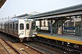
SEPTA's Market-Frankford Line at 63rd Street Station in West Philadelphia


See also
 In Spanish: Valle de Delaware para niños
