
Delta County, Michigan facts for kids
Quick facts for kids
Delta County
|
|
|---|---|

Delta County Courthouse in Escanaba
|
|

Location within the U.S. state of Michigan
|
|
 Michigan's location within the U.S. |
|
| Country | |
| State | |
| Founded | March 9, 1843 (authorized) 1861 (organized) |
| Seat | Escanaba |
| Largest city | Escanaba |
| Area | |
| • Total | 1,991 sq mi (5,160 km2) |
| • Land | 1,171 sq mi (3,030 km2) |
| • Water | 820 sq mi (2,100 km2) 41%% |
| Population
(2020)
|
|
| • Total | 36,903 |
| • Density | 32/sq mi (12/km2) |
| Time zone | UTC−5 (Eastern) |
| • Summer (DST) | UTC−4 (EDT) |
| Congressional district | 1st |
Delta County is a county in the Upper Peninsula in the U.S. state of Michigan. As of the 2020 Census, the population was 36,903. The county seat is Escanaba. The county was surveyed in 1843 and organized in 1861. Its name originates from the Greek letter "delta", which refers to the triangular shape of the original county which included segments of Menominee, Dickinson, Iron, and Marquette counties. Recreation and forest products are major industries, and crops include hay, corn, small grains, potatoes, and strawberries.
Delta County comprises the Escanaba, MI Micropolitan Statistical Area.
Contents
Geography
According to the U.S. Census Bureau, the county has a total area of 1,991 square miles (5,160 km2), of which 1,171 square miles (3,030 km2) is land and 820 square miles (2,100 km2) (41%) is water. It is the fifth-largest county in Michigan by land area.
Adjacent counties
- Alger County, Michigan (north)
- Schoolcraft County, Michigan (east)
- Leelanau County, Michigan (southeast)
- Door County, Wisconsin (south/CST Border)
- Menominee County, Michigan (west/CST Border)
- Marquette County, Michigan (northwest)
National protected area
- Hiawatha National Forest (part)
Demographics
| Historical population | |||
|---|---|---|---|
| Census | Pop. | %± | |
| 1860 | 1,172 | — | |
| 1870 | 2,542 | 116.9% | |
| 1880 | 6,812 | 168.0% | |
| 1890 | 15,330 | 125.0% | |
| 1900 | 23,881 | 55.8% | |
| 1910 | 30,108 | 26.1% | |
| 1920 | 30,909 | 2.7% | |
| 1930 | 32,280 | 4.4% | |
| 1940 | 34,037 | 5.4% | |
| 1950 | 32,913 | −3.3% | |
| 1960 | 34,298 | 4.2% | |
| 1970 | 35,924 | 4.7% | |
| 1980 | 38,947 | 8.4% | |
| 1990 | 37,780 | −3.0% | |
| 2000 | 38,520 | 2.0% | |
| 2010 | 37,069 | −3.8% | |
| 2020 | 36,903 | −0.4% | |
| US Decennial Census 1790-1960 1900-1990 1990-2000 2010-2018 |
|||
The 2010 United States Census indicates Delta County had population of 37,069. This decrease of 1,451 people from the 2000 United States Census represents a 3.8% population decrease during that 10-year period. In 2010 there were 15,992 households and 10,381 families in the county. The population density was 31.7 per square mile (12.2 per km2). There were 20,214 housing units at an average density of 17.3 per square mile (6.7 per km2). 94.7% of the population were White, 2.4% Native American, 0.4% Asian, 0.2% Black or African American, 0.2% of some other race and 2.1% of two or more races. 0.9% were Hispanic or Latino (of any race). 20.8% were of French, French Canadian or Cajun, 15.5% German, 10.3% Swedish and 7.6% Irish ancestry.
There were 15,992 households, out of which 25.5% had children under the age of 18 living with them, 51.7% were husband and wife families, 8.8% had a female householder with no husband present, 35.1% were non-families, and 29.8% were made up of individuals. The average household size was 2.28 and the average family size was 2.80.
The county population contained 20.9% under age of 18, 7.3% from 18 to 24, 21.1% from 25 to 44, 31.6% from 45 to 64, and 19.1% who were 65 years of age or older. The median age was 46 years. 49.5% of the population were male, and 50.5% of the population female.
The 2010 American Community Survey 3-year estimate indicates the median income for a household in the county was $40,967 and the median income for a family was $49,557. Males had a median income of $28,702 versus $15,093 for females. The per capita income for the county was $21,751. About 2.4% of families and 13.2% of the population were below the poverty line, including 17.4% of those under the age 18 and 8.5% of those age 65 or over.
Transportation
Major highways
 US 2 – runs east–west through the lower part of the county. Enters from Schoolcraft County east of Garden Corners and runs west to intersection with US41 at Rapid River.
 US 41 – runs north–south through central part of the county. Enters from Alger County at Trenary and runs south to Rapid River, then SW along Lake Michigan shore to SW corner of county.
 M-35 – enters from Marquette County at NW corner of Delta County. Runs SE to intersection with US41 at Gladstone.
 M-69 – runs east–west across SW tip of county. Enters from Menominee County at Schaffer and runs SE to intersection with US41 west of Narenta.
- M-183 – runs from south tip of county at Sac Bay, NE to intersection with US2 at Garden Corners.
Airport
The county is served by Delta County Airport (KESC), southwest of Escanaba. It provides scheduled airline service to Detroit.
Communities

Cities
Villages
Unincorporated communities
- Bark River
- Fayette
- Garden Corners
- Isabella
- Schaffer
- Rapid River
Townships
- Baldwin Township
- Bark River Township
- Bay de Noc Township
- Brampton Township
- Cornell Township
- Ensign Township
- Escanaba Township
- Fairbanks Township
- Ford River Township
- Garden Township
- Maple Ridge Township
- Masonville Township
- Nahma Township
- Wells Township
Images for kids
-
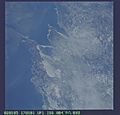
Taken at 11:01:01 AM CST on January 5, 2002 during Expedition 4 of the International Space Station
-
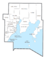
U.S. Census data map showing local municipal boundaries within Delta County. Shaded areas represent incorporated cities.


See also
 In Spanish: Condado de Delta (Míchigan) para niños
