
Dimondale, Michigan facts for kids
Quick facts for kids
Dimondale, Michigan
|
|
|---|---|
|
Village
|
|

Location of Dimondale, in Eaton County, Michigan
|
|
| Country | United States |
| State | Michigan |
| County | Eaton |
| Area | |
| • Total | 0.93 sq mi (2.42 km2) |
| • Land | 0.89 sq mi (2.31 km2) |
| • Water | 0.04 sq mi (0.11 km2) |
| Elevation | 863 ft (263 m) |
| Population
(2010)
|
|
| • Total | 1,234 |
| • Estimate
(2019)
|
1,257 |
| • Density | 1,412.36/sq mi (545.01/km2) |
| Time zone | UTC-5 (Eastern (EST)) |
| • Summer (DST) | UTC-4 (EDT) |
| ZIP code |
48821
|
| Area code(s) | 517 |
| FIPS code | 26-22380 |
| GNIS feature ID | 0624685 |
Dimondale is a village in Eaton County in the U.S. state of Michigan. The population was 1,234 at the 2010 census. The village is located within Windsor Charter Township. Dimondale is a suburb of Lansing, which is northeast of the village in Ingham County.
History
The Potawatomi originally had a permanent camp along the Grand River in the Dimondale area before white settlement began in the 1830s. Relations between white settlers (most of whom were from New York and New England) and the Potowatomie were generally cordial with local residents permanently deeding 10 acres (40,000 m2) of land near the river to the local Indians. The local band held the deed to the leased land until the Potowatomie were forced west by the Indian Removal Act. Isaac M. Dimond came to the area in 1848 and, as one of his enterprises, in 1850 began to construct a dam, just east of Silver Creek on the Grand River near the center of section 15. By 1852, the dam was completed and a saw mill was in operation. He built a grist mill in 1856. On August 6, 1856, Hosey Harvey surveyed the village in order for Dimond to have it platted with the name "Dimondale". An unusual feature of the village is that its streets run Northeast to Southwest and Northwest to Southeast, while most streets and roads in the surrounding area, indeed the whole Midwest, run North-South and East-West. Its borders make a rough diamond shape on a map.
A post office named "East Windsor" had been established in the eastern part of Windsor Township in about 1860. This office was transferred to Dimondale and renamed in 1872. In 1878 the Lake Shore and Michigan Southern Railway came through and the area was given a station referring to it as Dimondale. In 1906, Dimondale incorporated as a village.
From 1929 to 1963, Dimondale had its own high school, until it merged with the Holt School District. This occurred after the school district ran into tax issues due to the sparse business landscape in the village. The final Superintendent for Dimondale was Harvey E. Wood, a school administrator who later moved to Holt's system as the Transportation Manager, then eventually to Ingham Intermediate School District (IISD) as Vice Superintendent. Dimondale almost merged with the Eaton Rapids School district, however due to Mr. Wood's prior mentor/student relationship with Holt's Superintendent (Maurice Pernert), the merge with Holt's school system took place.
In 1962, Interstate 96 was built through Windsor Township, bringing many new businesses to the area.
In the 1960s–70s, Dimondale served as a regionally and nationally recognized hotspot for championship horseshoe pitching, earning it the nickname "Horseshoe Capital of the World." The Dimondale Horseshoe Club was founded in 1964 and the village played host to the 1965 Michigan state tournament. In 1970, DHC merged with the Chief Okemos Sportsman's Club, which is still in existence. Dimondale natives and accomplished horseshoe pitchers James Compton, Gilbert Kimball, Pat Smith, Victor Benson, Fred Smith Sr., and Fred Smith Jr. have been inducted into the Wolverine State Horseshoe Pitcher's Association (WSHPA) Hall of Fame. The greatest horseshoe pitching legend emanating from the clay courts of Dimondale tells how Fred Smith Jr. would have his brother Norman place his chin atop an opposing stake while Fred would proceed to pitch 40-foot (12 m) ringers that would clang just inches below Norman's smiling face.
Geography
According to the United States Census Bureau, the village has a total area of 0.94 square miles (2.43 km2), of which 0.90 square miles (2.33 km2) is land and 0.04 square miles (0.10 km2) is water.
Demographics
| Historical population | |||
|---|---|---|---|
| Census | Pop. | %± | |
| 1880 | 304 | — | |
| 1890 | 320 | 5.3% | |
| 1910 | 341 | — | |
| 1920 | 300 | −12.0% | |
| 1930 | 545 | 81.7% | |
| 1940 | 604 | 10.8% | |
| 1950 | 774 | 28.1% | |
| 1960 | 866 | 11.9% | |
| 1970 | 970 | 12.0% | |
| 1980 | 1,008 | 3.9% | |
| 1990 | 1,247 | 23.7% | |
| 2000 | 1,342 | 7.6% | |
| 2010 | 1,234 | −8.0% | |
| 2019 (est.) | 1,257 | 1.9% | |
| U.S. Decennial Census | |||
2010 census
As of the census of 2010, there were 1,234 people, 504 households, and 351 families living in the village. The population density was 1,371.1 inhabitants per square mile (529.4/km2). There were 530 housing units at an average density of 588.9 per square mile (227.4/km2). The racial makeup of the village was 92.7% White, 0.7% African American, 0.9% Native American, 0.8% Asian, 1.6% from other races, and 3.2% from two or more races. Hispanic or Latino of any race were 4.1% of the population.
There were 504 households, of which 28.0% had children under the age of 18 living with them, 57.5% were married couples living together, 9.3% had a female householder with no husband present, 2.8% had a male householder with no wife present, and 30.4% were non-families. 25.8% of all households were made up of individuals, and 13.1% had someone living alone who was 65 years of age or older. The average household size was 2.43 and the average family size was 2.89.
The median age in the village was 47 years. 21.1% of residents were under the age of 18; 6.8% were between the ages of 18 and 24; 19.3% were from 25 to 44; 36.7% were from 45 to 64, and 16.3% were 65 years of age or older. The gender makeup of the village was 47.2% male and 52.8% female.
Climate
This climatic region is typified by large seasonal temperature differences, with warm to hot (and often humid) summers and cold (sometimes severely cold) winters. According to the Köppen Climate Classification system, Dimondale has a humid continental climate, abbreviated "Dfb" on climate maps.
- Durant, Samuel W. Title: History of Ingham and Eaton counties, Michigan, with illustrations and biographical sketches of their prominent men and pioneers. Philadelphia: D. W. Ensign & co., 1880. p. 541.
- Romig, Walter. Michigan Place Names. Detroit: Wayne State University Press, 1986.
- Caruss, Thelma. Windsor Township, Heritage & Horizons. East Lansing: Vision Creative, 1976; 1998 reprint.
Education
Holt Public Schools operates Dimondale Elementary School. Holt High School is the Holt district's high school.
Images for kids
-
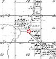
Site of Grand River dam (star) built by I. Dimond in 1850, on a 1827 survey map by M. Evans of section 15 of Windsor township, Eaton County, Michigan

See also
 In Spanish: Dimondale para niños
