Dingo, Queensland facts for kids
Quick facts for kids DingoQueensland |
|||||||||||||||
|---|---|---|---|---|---|---|---|---|---|---|---|---|---|---|---|

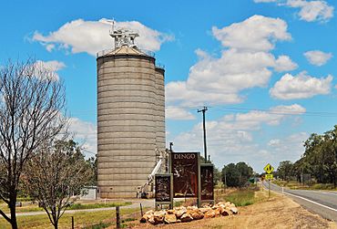
Grain silos at Dingo, 2017
|
|||||||||||||||
| Population | 340 (2016 census) | ||||||||||||||
| • Density | 0.2104/km2 (0.545/sq mi) | ||||||||||||||
| Postcode(s) | 4702 | ||||||||||||||
| Area | 1,616.2 km2 (624.0 sq mi) | ||||||||||||||
| Time zone | AEST (UTC+10:00) | ||||||||||||||
| Location |
|
||||||||||||||
| LGA(s) | Central Highlands Region | ||||||||||||||
| State electorate(s) | Gregory | ||||||||||||||
| Federal Division(s) | Flynn | ||||||||||||||
|
|||||||||||||||
Dingo is a rural town and locality in the Central Highlands Region, Queensland, Australia. In the 2016 census, the locality of Dingo had a population of 340 people.
Contents
Geography
The town is on the Capricorn Highway, 762 kilometres (473 mi) north west of the state capital Brisbane and 148 kilometres (92 mi) west of the regional centre of Rockhampton.
History
The town was surveyed in 1889 and took its name from the nearby Dingo Creek. For a time in 1940 the town was known as Remo. Dingo Post Office opened on 1 October 1876.
In 1973, a population of Bridled nail-tail wallabies (Onychogalea fraenata) was found in the Dingo area by a fencing contractor. Until this sighting the species was thought to be extinct having not been seen since 1937. The area where the wallabies was rediscovered was protected as Taunton National Park.
In the 2006 census, Dingo had a population of 263 people.
Education
Dingo State School is a government primary (Early Childhood-6) school for boys and girls on the corner of Kennedy amd Normanby Streets (23°38′44″S 149°19′49″E / 23.6455°S 149.3302°E). In 2018, the school had an enrolment of 47 students with 5 teachers (4 full-time equivalent) and 6 non-teaching staff (4 full-time equivalent).
Notable residents
Australian rugby league player Ben Hunt grew up in Dingo.


