
Dobbins Heights, North Carolina facts for kids
Quick facts for kids
Dobbins Heights, North Carolina
|
|
|---|---|

Dobbins Heights, North Carolina
Location in North Carolina
|
|
| Country | United States |
| State | North Carolina |
| County | Richmond |
| Area | |
| • Total | 0.88 sq mi (2.28 km2) |
| • Land | 0.88 sq mi (2.28 km2) |
| • Water | 0.00 sq mi (0.00 km2) |
| Elevation | 387 ft (118 m) |
| Population
(2010)
|
|
| • Total | 866 |
| • Estimate
(2019)
|
839 |
| • Density | 951.25/sq mi (367.34/km2) |
| Time zone | UTC-5 (Eastern (EST)) |
| • Summer (DST) | UTC-4 (EDT) |
| ZIP code |
28345
|
| Area code(s) | 910 |
| FIPS code | 37-17325 |
| GNIS feature ID | 1027618 |
Dobbins Heights is a town in Richmond County, North Carolina, United States. The population was 866 at the 2010 census.
Geography
Dobbins Heights is located at 34°54′12″N 79°41′28″W / 34.90333°N 79.69111°W (34.903388, -79.691220).
According to the United States Census Bureau, the town has a total area of 0.9 square miles (2.3 km2), all of it land.
Demographics
| Historical population | |||
|---|---|---|---|
| Census | Pop. | %± | |
| 1990 | 1,144 | — | |
| 2000 | 936 | −18.2% | |
| 2010 | 866 | −7.5% | |
| 2019 (est.) | 839 | −3.1% | |
| U.S. Decennial Census | |||
2020 census
| Race | Number | Percentage |
|---|---|---|
| White (non-Hispanic) | 73 | 10.63% |
| Black or African American (non-Hispanic) | 545 | 79.33% |
| Native American | 6 | 0.87% |
| Asian | 1 | 0.15% |
| Other/Mixed | 45 | 6.55% |
| Hispanic or Latino | 17 | 2.47% |
As of the 2020 United States census, there were 687 people, 404 households, and 218 families residing in the town.
Images for kids
-
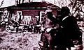
A home in Dobbins Heights, 1972

See also
 In Spanish: Dobbins Heights para niños

All content from Kiddle encyclopedia articles (including the article images and facts) can be freely used under Attribution-ShareAlike license, unless stated otherwise. Cite this article:
Dobbins Heights, North Carolina Facts for Kids. Kiddle Encyclopedia.