Dooly County, Georgia facts for kids
Quick facts for kids
Dooly County
|
|
|---|---|

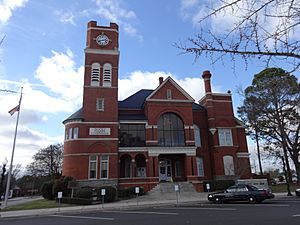
Dooly County Courthouse in Vienna
|
|

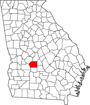
Location within the U.S. state of Georgia
|
|
 Georgia's location within the U.S. |
|
| Country | |
| State | |
| Founded | May 15, 1821 |
| Named for | John Dooly |
| Seat | Vienna |
| Largest city | Vienna |
| Area | |
| • Total | 397 sq mi (1,030 km2) |
| • Land | 392 sq mi (1,020 km2) |
| • Water | 5.3 sq mi (14 km2) 1.3%% |
| Population | |
| • Estimate
(2019)
|
13,390 |
| • Density | 38/sq mi (15/km2) |
| Time zone | UTC−5 (Eastern) |
| • Summer (DST) | UTC−4 (EDT) |
| Congressional district | 2nd |
Dooly County is a county located in the central portion of the U.S. state of Georgia. As of the 2010 census, the population was 14,918. The county seat is Vienna. The county was created by an act of the Georgia General Assembly on May 15, 1821, and named for Colonel John Dooly, a Georgia American revolutionary war fighter. It was one of the original landlot counties created from land ceded from the Creek Nation.
The entire county of Crisp and parts of Macon, Pulaski, Turner, Wilcox and Worth counties were formed from Dooly's original borders.
Contents
Geography
According to the U.S. Census Bureau, the county has a total area of 397 square miles (1,030 km2), of which 392 square miles (1,020 km2) is land and 5.3 square miles (14 km2) (1.3%) is water.
The western two-thirds of Dooly County, from west of Unadilla south to Pinehurst, then to the southeastern corner of the county, is located in the Middle Flint River sub-basin of the ACF River Basin (Apalachicola-Chattahoochee-Flint River Basin). The northeastern and eastern portion of Dooly County is located in the Lower Ocmulgee River sub-basin of the Altamaha River basin. The very southeastern corner of the county is located in the Alapaha River sub-basin of the Suwannee River basin.
Major highways
Adjacent counties
- Houston County - northeast
- Pulaski County - east
- Wilcox County - southeast
- Crisp County - south
- Sumter County - west
- Macon County - northwest
Demographics
| Historical population | |||
|---|---|---|---|
| Census | Pop. | %± | |
| 1830 | 2,135 | — | |
| 1840 | 4,427 | 107.4% | |
| 1850 | 8,361 | 88.9% | |
| 1860 | 8,917 | 6.6% | |
| 1870 | 9,790 | 9.8% | |
| 1880 | 12,420 | 26.9% | |
| 1890 | 18,146 | 46.1% | |
| 1900 | 26,567 | 46.4% | |
| 1910 | 20,554 | −22.6% | |
| 1920 | 20,522 | −0.2% | |
| 1930 | 18,025 | −12.2% | |
| 1940 | 16,886 | −6.3% | |
| 1950 | 14,159 | −16.1% | |
| 1960 | 11,474 | −19.0% | |
| 1970 | 10,404 | −9.3% | |
| 1980 | 10,826 | 4.1% | |
| 1990 | 9,901 | −8.5% | |
| 2000 | 11,525 | 16.4% | |
| 2010 | 14,918 | 29.4% | |
| 2019 (est.) | 13,390 | −10.2% | |
| U.S. Decennial Census 1790-1960 1900-1990 1990-2000 2010-2019 |
|||
2010 census
As of the 2010 United States Census, there were 14,918 people, 5,286 households, and 3,576 families living in the county. The population density was 38.1 inhabitants per square mile (14.7/km2). There were 6,328 housing units at an average density of 16.1 per square mile (6.2/km2). The racial makeup of the county was 49.9% black or African American, 45.6% white, 0.6% Asian, 0.1% American Indian, 2.8% from other races, and 0.9% from two or more races. Those of Hispanic or Latino origin made up 5.8% of the population. In terms of ancestry, 8.9% were American, and 8.7% were English.
Of the 5,286 households, 31.3% had children under the age of 18 living with them, 43.2% were married couples living together, 19.1% had a female householder with no husband present, 32.3% were non-families, and 28.8% of all households were made up of individuals. The average household size was 2.45 and the average family size was 2.99. The median age was 40.0 years.
The median income for a household in the county was $31,038 and the median income for a family was $39,622. Males had a median income of $36,344 versus $27,557 for females. The per capita income for the county was $14,871. About 21.0% of families and 27.1% of the population were below the poverty line, including 41.9% of those under age 18 and 22.3% of those age 65 or over.
2020 census
The 2020 United States Census indicated that the county lost 29% of its population in the preceding decade. This was the largest percentage loss of any county in the state.
| Race | Num. | Perc. |
|---|---|---|
| White (non-Hispanic) | 4,611 | 41.14% |
| Black or African American (non-Hispanic) | 5,540 | 49.43% |
| Native American | 17 | 0.15% |
| Asian | 51 | 0.46% |
| Pacific Islander | 2 | 0.02% |
| Other/Mixed | 190 | 1.7% |
| Hispanic or Latino | 797 | 7.11% |
As of the 2020 United States census, there were 11,208 people, 5,020 households, and 3,350 families residing in the county.
Communities
Economy
The Big Pig Jig, Georgia's official State Barbecue Cooking Championship, is held annually in Fall in Dooly County and attracts a national audience. The county is also notable for cotton and peanut production.
Education
Dooly County Elementary School Dooly County Middle school Dooly County High School http://www.dooly.k12.ga.us/
Notable people
- John Dooly after whom the county was named
- Rooney L. Bowen, Georgia businessman and politician
- George Busbee, governor of Georgia
- Walter F. George, U.S. Senator
- Jody Powell, press secretary and aide to Jimmy Carter
- Roger Kingdom, Olympic gold medalist in track and field
- David Ragan, NASCAR driver
- Keith Mumphery, NFL player
- Julian Webb, judge on the Georgia Court of Appeals and member of the Georgia State Senate.
See also
 In Spanish: Condado de Dooly para niños

