
Doonside, New South Wales facts for kids
Quick facts for kids DoonsideSydney, New South Wales |
|||||||||||||||
|---|---|---|---|---|---|---|---|---|---|---|---|---|---|---|---|
Kildare_Road_Doonside.jpg)
Kildare Road, Doonside 2767 NSW
|
|||||||||||||||
| Population | 13,451 (2016 census) | ||||||||||||||
| Established | 1929 | ||||||||||||||
| Postcode(s) | 2767 | ||||||||||||||
| Elevation | 43 m (141 ft) | ||||||||||||||
| Location | 40 km (25 mi) west of Sydney CBD | ||||||||||||||
| LGA(s) | City of Blacktown | ||||||||||||||
| State electorate(s) | Blacktown | ||||||||||||||
| Federal Division(s) | Chifley | ||||||||||||||
|
|||||||||||||||
Doonside is a suburb in Sydney, in the state of New South Wales, Australia. Doonside is located 40 kilometres west of the Sydney central business district, in the local government area of the City of Blacktown and is part of the Greater Western Sydney region. Featherdale Wildlife Park and the Nurragingy Nature Reserve are popular local tourist attractions.
Contents
History
The Original Land Owners
The Duruk people were once the owners of local land. The area now known as Doonside was named 'Bungarribee' (Bung meaning the 'creek' and garribee meaning 'cockatoo').
In 1802, Governor Philip Gidley King reserved a large proportion of Duruk land for a Government Stock Reserve. The next twenty years saw Doonside as grazing land for cattle and sheep owned by convict herdsmen. In 1823 Aboriginal owned land was granted by Governor Thomas Brisbane to Scottish immigrant, Robert Crawford. Robert named his 2,000 acre (8 km²) grant 'Doonside' after his family home in Scotland, which was known as the River Doon. The grant was also known as Hill-end but later the area became known as Crawford, before officially becoming Doonside.
In 1823, Robert James Crawford (1799-1848) Robert had four children with Mary Campbell (d. 1832): Mary Crawford (b. 1826), Robert Crawford (1827-1906), George Canning Crawford (b. 1828), and Agnes C. Crawford (b. 1831). (Robert Crawford's four children's names are used today at Crawford Public School as sporting house teams). The elder Robert Crawford married Miss Jones of Bligh Street, Sydney, in 1832.
Robert Crawford (1827-1906) married Victoria Margaret Smyth in 1868. Their son, Robert (1868-1930), born in the same year became a published poet.
Bungarribee House
In 1824 the Southern area of Doonside was granted to a Scottish-born settler named John Campbell (1771-1827). Campbell began to erect a homestead on the property which he ran as a convict farm to help feed the growing colony of New South Wales. The house was not quite finished at the time of Campbell's death in October 1827 and was completed and extended by Thomas Icely following his purchase of the property in 1828.
The property and house had a series of owners and tenants in the 19th and 20th centuries until acquired by the Commonwealth Overseas Telecommunications company in 1950. The house, deliberately left to decay, was demolished in May 1957 by the company (O.T.C). A small protest by local residents tried in vein to save the historic house, and the newly formed historic trust were unable to save the Homestead.
Wolkara
The Doonside name was changed briefly in 1921 to an Aboriginal name ‘Wolkara’ When the new railway station was being constructed, Wolkara was also the name of the post office that opened here in 1921, but in April 1929 it was changed back to Doonside, after local residents protested at the name change.
Early Doonside
There was no electricity until 1929 and water was drawn from wells. Horse-drawn carts would deliver bread and meat. Blacktown was visited by train as there weren't any buses or schools. Parramatta and Penrith, were the nearest high schools.
A store and post office were opened unofficially in 1926 by Bill Francis on the corner of Hillend Road and Cross Street. For some years his nephew Jack Francis operated the post office on the other side of the railway line but once it was made official it returned to its original site until 1987.
In 1955 electric trains came to Doonside and Edith Crawford from the founding family, also being the oldest inhabitant, was given the privilege of 'cutting the ribbon'. Her death was in 1956.
At the time of World War 1
Prior to 1916, the only development at Doonside was confined to the Crawford family. The Crawford homestead was on the south side of the railway line facing Doonside Road. Kelburn Crawford's daughters house, was between the homestead and Bungarribee. North of the line on the corner of Hillend Road and Doonside Crescent, was a brick cottage owned by the Italian family, Luparno. Opposite was a small gatekeepers cottage.
A brick home, owned by another Crawford daughter, was in Doonside Crescent. Properties fronted Hillend Road and were owned by Crawford children. Another cottage in Hillend Road was owned by the family named Harrison, in-laws to Crawford children. A workman's timber cottage was on the hill towards the tileworks' site.
The only road into Doonside was Doonside Road, running from Western Highway. Hillend Road only went as far as Power Street after which there was a track to Richmond Road ending in a gate. Power Street went to Plumpton with the crossing over Eastern Creek being rough and dangerous in wet weather.
After the war (1914-1918), the company of Porter and Galbraith bought property from Crawford and erected a tileworks (PGH) in an area which is now the suburb of Woodcroft. A soldier's settlement of about twenty poultry farms was established between the railway line and Bungarribee Road. Part of this land, during the 1930s depression, became a woman's settlement.
People
Doonside's population was 13,087 in the 2011 Australian census. There was a mix of housing tenures in the suburb with 21.8% of properties owned outright, 33.6% being purchased and 41.2% being rented. The median family income of $1,203 per week was slightly lower than average and while the median rent ($210 per week) was also lower than average, the median mortgage repayment of $1,900 per month was higher. The most common industry of employment was hospitals (3.9%).
The most common countries of birth were Philippines 7.7%, India 3.6%, Fiji 3.2%, New Zealand 2.6% and England 1.5%. The most common ancestries in Doonside (State Suburbs) were Australian 20.0%, English 16.0%, Filipino 8.0%, Indian 5.4% and Irish 4.0%. Other languages spoken at home included Tagalog 4.8%, Arabic 4.2%, Hindi 3.9%, Filipino 2.5% and Punjabi 1.7%.
Notable residents include:
- Robert Crawford (1868–1930), poet
- Henry Kater (1841–1924), chairman of CSR Limited from 1901-1920
- V8 Supercars Ford driver Mark Winterbottom was brought up in Doonside.
- Fatso the Wombat (A Country Practice), was a resident of Featherdale Wildlife Park
- Craig Moore (Socceroos and Glasgow Rangers Captain) played for the Doonside Hawks Soccer Club and went to Crawford Public School and Doonside High School.
Transport
Doonside railway station is on the Main Western railway line. It is served by Sydney Trains North Shore & Western Line services. The Great Western Highway runs along the southern border and the M4 (Sydney) is just to the south. Busways offers a number of bus services in the suburb including:
- route 753 from Doonside station to Blacktown station through the north of the suburb;
- routes 725/726 from Doonside to Blacktown station through the south of the suburb.
- route 756 from Blacktown to Mount Druitt, passing through the north of Doonside and providing connections with suburbs such as Woodcroft, Glendenning, Plumpton and Rooty Hill.
Doonside Station 1880
A single line opened from Blacktown to Rooty Hill on 23 December 1861. The construction contract for the Blacktown to Kingswood section was awarded to Peto, Brassey & Betts in August 1859. The line was duplicated in 1886 and the station opened on 27 September 1880. The station was renamed Wolkara on 1 February 1921, and was subsequently renamed again to Doonside on 12 February 1921. The line was electrified on 9 October 1955.
The present station was upgraded in 1955, replacing the original buildings. The design of the station buildings applied the railway Stripped Functionalist style, as was done at other stations between Lidcombe and St. Mary's. The station was one part of a much larger scheme to increase the tracks to four main lines between Lidcombe and St. Mary's during World War II in order to provide maximum track capacity to the American ammunition and general store built at Ropes Creek. Quadruplication was completed in 1981.
A signal box was incorporated into the 1955 building but was closed in 1963 when automatic boom gates were provided at an adjacent level crossing which was itself removed in 1980. The signal box equipment has been removed.
The pedestrian bridge that provides access to the platforms was built in 1958. Its twin beam construction is typical of 1940's footbridges on the Western line quadruplication. Since 1990, every component of the bridge, except the steel structure, has been replaced.
Recreation
On the western edge of Doonside lies the Nurragingy Reserve, which is situated in the Western Sydney Regional Parklands. The Reserve is a 90ha park featuring picnic grounds and original bushland. It was established a nature reserve in 1981 and named after Nurragingy, a Darug man given a land grant in the Blacktown area in 1819. Just south of the railway line is the Featherdale Wildlife Park, a private zoo established in 1953 and specialising in Australian native animals and birds.
Across the railway line from Nurragingy is Kareela Reserve, a sporting complex, home to a number of local sporting teams including the Doonside Roos rugby league team, Doonside Cricket Club and Doonside Little Athletics. The Doonside Hawks soccer club, the junior club of former Socceroos Captain Craig Moore, plays out of Glendenning Reserve in neighbouring Glendenning while the Doonside Diamonds Netball Club play all their games (home and away) at the Blacktown City Netball Association complex in Blacktown. All these clubs use maroon and white as their colours.
Images for kids
-
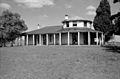
Bungarribee Homestead, 1954 Doonside
.jpg)
