
Door Peninsula facts for kids
Quick facts for kids
Designations
|
|
| Official name: Door Peninsula Coastal Wetlands | |
| Criteria: | Door County § Wetlands |
|---|---|
| Designated: | 10 June 2014 |
| Reference #: | 2218 |

The Door Peninsula is a peninsula in eastern Wisconsin, separating the southern part of the Green Bay from Lake Michigan. The peninsula includes northern Brown and Kewaunee counties and all of Door County. It is the western portion of the Niagara Escarpment. Well known for its cherry and apple orchards, the Door Peninsula is a popular tourism destination. With the 1881 completion of the Sturgeon Bay Ship Canal, the northern half of the peninsula became an island.
Limestone outcroppings of the Niagara Escarpment are visible on both shores of the peninsula, but are larger and more prominent on the Green Bay side as seen at the Bayshore Blufflands. Progressions of dunes have created much of the rest of the shoreline, especially on the east side. Flora along the shore provide clear evidence of plant succession. The middle of the peninsula is mostly flat, cultivated land. Beyond the peninsula's northern tip is a series of islands, the largest of which is Washington Island. The partially submerged ridge extends farther north, becoming the Garden Peninsula in Upper Michigan.
Contents
History
Archaeology

Archaeological evidence shows habitation of the peninsula and its islands by several different Native American groups.
Paleo-Indian artifacts were found at the Cardy Site, including four Gainey points. The relationship between Gainey points and the more ubiquitous Clovis points is being researched, but there are some similarities. Most of the material collected from the Cardy site by 2003 was made of Moline chert, which is not found in Wisconsin. As of 2007, seven Clovis points have been found in the county. Careful study of certain Paleo-Indian artifacts from western Wisconsin suggests that they were made in the Door peninsula and carried across the state.
Artifacts from an ancient village site at Nicolet Bay Beach date to about 400 BC. This site was occupied by various cultures until about 1300 AD.
In 246 B.C (±25 years), a dog was buried in a Native American burial site on Washington Island.
Jean Nicolet
Two locations on the peninsula claim to be the landing site of French explorer Jean Nicolet in 1634, who was searching for a water route through North America to Asia: Horseshoe Island, which is part of Peninsula State Park, and Red Banks, which is about 7 miles north of what is now Green Bay. Nicolet is remembered in Wisconsin lore for having mistaken the Ho-Chunk Indians for Asians and celebrating, believing he had reached the Far East. Nicolet had heard long before coming that the people living along these shores were called Winnebago ("the people from the stinking water") and, perhaps erroneously, "the People of the Sea". He concluded that this name meant they were from or living near the Pacific Ocean with its aromatic salt air and that they would be a direct link to the people of China, if not from China.
Origin of the name
The name of the peninsula and the county comes from the name of a route between Green Bay and Lake Michigan. Humans, whether Native Americans, early explorers, or American ship captains, have been well aware of the dangerous water passage that lies between the Door Peninsula and Washington Island, connecting the bay to the rest of Lake Michigan. This small strait is now littered with shipwrecks. It was named by the Native Americans and translated into French as Porte des Morts: in English, "Death's Door".
Potawatomi and Menominee
Before and during the 19th century, various Native Americans occupied the Door Peninsula and nearby islands. 17th-century French explorers made contact with various tribes in the area. In 1634, the Jean Nicolet expedition landed at Rock Island. This is considered the first visit by men of European descent to what is now Wisconsin. In 1665, Pierre-Esprit Radisson and Médard des Groseilliers spent the winter with the Potawatomi. In 1669, Claude-Jean Allouez also wintered with the Potawatomi. He mentioned an area called "la Portage des Eturgeons." In 1673, Jacques Marquette and Louis Jolliet stayed in the area about three months as part of their exploration. In 1679, the party led by La Salle purchased food from a village of Potawatomi in what is now Robert La Salle County Park. During the 1670s Louis André ministered to about 500 Native Americans at Rowleys Bay, where he erected a cross. The cross stood until about 1870. Around 1690, Nicolas Perrot visited the Potawatomi on Washington Island. In 1720, Pierre François Xavier de Charlevoix visited the area with eight experienced voyageurs.
Six Jesuit rings marked with letters or symbols and turquoise colored glass trade beads were found on Rock Island in remains left by Potowatomi, Odawa, and Huron-Peton-Odawa Native Americans during the 17th and 18th centuries. The remains of four Native American buildings were documented at the Rock Island II Site during 1969–1973 excavations.
By the end of French rule over the area in 1763, the Potawatomi had begun a move to the Detroit area, leaving the large communities in Wisconsin. Later, some Potawatomi moved back from Michigan to northern Wisconsin. Some but not all Potawatomi later left northern Wisconsin for northern Indiana and central Illinois.
In 1815, Captain Talbot Chambers was falsely reported to have died fighting Blackhawk Indians on Chambers Island; the island was named for him in 1816. In the spring 1833, Odawa on Detroit Island were baptized during an eight day visit by Frederic Baraga. During an attack in 1835, one of two fishermen squatting on Detroit Island was shot and killed along with one or more Native Americans. The other fisherman was rescued by a passing boat. From the 1840s to the 1880s, the Clark brothers operated a fishing camp at Whitefish Bay that employed 30 to 40 fishermen. Additionally, 200–300 Potawatomi extracted fish oil from the fish waste at the camp.

The Menominee ceded their claim to the Door Peninsula to the United States in the 1836 Treaty of the Cedars after years of negotiations with the Ho-Chunk and the U.S. government over how to accommodate the incoming populations of Oneida, Stockbridge-Munsee, and Brothertown peoples who had been removed from New York. As a result of this treaty, settlers could purchase land, but many fishermen still chose to live as squatters. At the same time, the more decentralized Potawatomi were divested of their land without compensation. Some Potawatomi as late as 1845 made sure to visit and gamble with the Menominee shortly after the periodic annuity payments were issued. Many emigrated to Canada because of multiple factors. One factor was invitations from Native Americans already in Canada for the Potawatomi to join them. Another was British policies to invite and encourage as much Indian emigration from the United States as possible. Even prior to their final emigration, many Potowatomis had periodically migrated into Canada to receive compensation related to their service on the British side during the War of 1812 and to pledge their continued loyalty. Another factor was a desire to avoid the harsh terms of the 1833 Treaty of Chicago, which compensated the Wisconsin Potowatomi with less than what was paid to Potowatomi from the Chicago area. Although not all Potawatomi participated in the Treaty of Chicago, it was federal policy that any who did not relocate westward as the treaty stipulated would not be compensated for their land. Additionally, some preferred the climate of the Great Lakes area over that of the Plains, and American governmental policy for the area beginning in 1837 tended towards forced rather than voluntary Indian removal. Moving to Canada became a way to stay in the Great Lakes area without risking removal.
Potawatomi Chief Simon Kahquados traveled to Washington, D.C. multiple times in an attempt to get the land back. In 1906, Congress passed a law to establish a census of all Potawatomi formerly living in Wisconsin and Michigan as a first step toward compensation. The 1907 "Wooster" roll, named after the clerk who compiled it, documented 457 Potawatomi living in Wisconsin and Michigan and 1423 in Ontario. Instead of returning the land, a meager monthly payment was issued. Although Kahquados was unsuccessful, he increased public awareness of Potawatomi history. In 1931, 15,000 people attended his burial in Peninsula State Park.
County border adjustments
.jpg)
In 1818, Michilimackinac and Brown counties were formed by the Michigan territorial legislature. The border between the two ran through the peninsula at Sturgeon Bay. What is now the southern part of Door County was in Brown County, while the northern part was in Michilimackinac County.

In 1836, the northern part of Door County was taken from Michilimackinac County and added to Brown County as part of an overall border adjustment limiting Michilimackinac to areas within the soon-to-be-reduced Michigan Territory.

When Door County was separated off from Brown County in 1851, it included what is now Kewaunee County. Kewaunee County was separated off of Door County in 1852.
Although the Door–Marinette county lines within the Wisconsin part of Green Bay were assigned to the "center of the main channel of Green Bay," not all maps drew the positions of the islands and the main channel of Green Bay correctly. In particular, some once incorrectly considered Green Island in what is now the town of Peshtigo in Marinette County to be in the town of Egg Harbor in Door County.
In 1923, Michigan claimed ownership of Plum, Detroit, Washington, and Rock islands in Door County, although it did not take possession of them. In 1926, the Supreme Court dismissed Michigan's claim. In doing so, the court mistakenly appeared to award islands north of Rock Island in Delta County to Wisconsin (and by extension to Door County). Door County never assumed jurisdiction over these Michigan islands, and the matter was fixed again before the Supreme Court in the 1936 Wisconsin v. Michigan decision, which left governance of the islands in Door and Delta counties as they had been before the litigation.
The more tourism-dominated northern part of the peninsula was acculturated from the professional and business classes of the tourists, while the more agriculture-dominated southern remained more rural in character. Due to economic, ethnic, and cultural differences between the northern and southern parts of the present-day Door County, arguments are sometimes started about the most appropriate place to draw the Door–Kewaunee line.
Geography
High points
Door County
Structures on high points

- A tower on Brussels Hill is owned by the Wisconsin Public Service Corporation.
- Boyer Bluff Lighthouse is an 80 foot (24 meters) tall skeleton tower on Washington Island's Boyer Bluff 45°25′12″N 86°56′09″W / 45.41998°N 86.93595°W, elevation 722 ft (220 meters)
- "The Mountain" at Mountain Park in Washington Island is the highest point on the island and has a lookout tower.
- Eagle Bluff Lighthouse on Eagle Bluff 45°10′27″N 87°13′19″W / 45.17415°N 87.22205°W, elevation 597 ft (182 meters)
- Pottawatomie Light on Pottawatomie Point on Rock Island.
- A wind turbine project on the escarpment was completed in 1999. At the time the 30.5-acre (12.3-ha) Rosiere Wind Farm was the largest in the eastern United States.
Other high points
- Deathdoor Bluff 45°17′47″N 87°03′55″W / 45.29637°N 87.06539°W, elevation 728 ft (222 meters)
- Ellison Bluff 45°15′32″N 87°06′08″W / 45.25888°N 87.10234°W, elevation 587 ft (179 meters)
- Mount Lowe 44°52′05″N 87°22′31″W / 44.86805°N 87.37538°W, elevation 728 ft (222 meters)
- Sister Bluffs 45°11′10″N 87°09′14″W / 45.1861°N 87.154°W, elevation 581 ft (177 meters)
- Svens Bluff 45°08′03″N 87°13′56″W / 45.13416°N 87.23233°W, elevation 633 ft (193 meters)
- Table Bluff 45°17′57″N 87°00′59″W / 45.29915°N 87.01651°W, elevation 623 ft (190 meters)
- Certain other high points are currently unnamed
Kewaunee County
- Cherneyville Hill44°25′33″N 87°43′50″W / 44.42583°N 87.73065°W, elevation 1,014 ft (309 meters)
- Dhuey Hill44°38′16″N 87°37′27″W / 44.63777°N 87.62426°W, elevation 912 ft (278 meters)
- Montpelier Hills44°26′09″N 87°42′53″W / 44.43583°N 87.71481°W, elevation 951 ft (290 meters)
Caves and sinkholes
| Sea caves of the Door Peninsula and Rock Island |
|||
   |
A pit cave containing the skeletal remains of both present-day and pre-Columbian animals opens at the southern base of Brussels Hill. It is the deepest known pit cave and the fourth-longest known cave of any sort in Wisconsin. It was discovered by excavating three sinkholes in an extensive project. Hundreds of sinkholes in Door County have been found and marked on an electronic map. Most sinkholes on the peninsula are formed by gradual subsidence of material into the hole rather than a sudden collapse. Some are regularly filled by tilling or natural erosion, only to subside more due to meltwater or heavy rain.
Many caves are found in the escarpment. One of them, Horseshoe Bay Cave, is Wisconsin's second-longest and contains a 45-foot-high underground waterfall. Horseshoe Bay Cave is home to rare invertebrates. Several tiny caves at Peninsula State Park are open and accessible to the public. Eagle Cave is larger but opens midway up the escarpment.
Only one cave not formed by karst or lakeshore erosion has been discovered in Door County. It opens in the basement of a nursing home in Sturgeon Bay.
Waters
Sturgeon Bay and Little Sturgeon are considered biodiversity hotspots because they support a large number of different fish species.
North of the peninsula, warm water from Green Bay flows into Lake Michigan on the surface, while at the same time, cold lakewater enters Green Bay deep underneath. This is a major reason why oxygen levels in the bay are often too low.
Salmon
Beginning in 1964, first coho and then Chinook salmon were stocked in Lake Michigan. New Chinook fingerling stocking in the spring and egg and milt collection from late September to early November primarily takes place at the Strawberry Creek Chinook Facility in southern Door County. The facility is a public attraction during stocking and collection times.
In recent years there has been concern that the alewife population will not support the salmon population, especially as the Chinook population has already collapsed in Lake Huron.
Chinook salmon are sought after by tourists enjoying chartered fishing trips. Several state record salmon have been caught out of Door County waters on the Lake Michigan side. In 1994 the state record Chinook was taken; it weighed 44 pounds, 15 ounces, and was 47.5 inches long. In 2016 the state record for pinook (a hybrid of the pink and Chinook salmons) was set at a weight of 9 pounds, 1.6 ounces, and 27.87 inches. In 2018, Kewaunee County ranked first in the state with 26,557 Chinook salmon caught. Door County ranked second with 14,268 fish caught.
| Commercial and recreational fishing | |||
      |
Spawning
Reefs and shoals in Door County waters
-
- Dunlap Reef 44°50′15″N 87°23′17″W / 44.8375°N 87.38815°W
- Fisherman Shoal 45°21′52″N 86°46′47″W / 45.36443°N 86.77984°W
- Four Foot Shoal 45°09′39″N 87°00′07″W / 45.16082°N 87.00206°W
- Hanover Shoal 45°08′53″N 87°19′01″W / 45.14804°N 87.31705°W
- Horseshoe Reefs 45°13′16″N 87°12′27″W / 45.2211°N 87.20761°W
- Larsons Reef 44°53′18″N 87°28′34″W / 44.88833°N 87.47621°W
- Middle Shoal 45°19′00″N 86°56′10″W / 45.31665°N 86.93623°W
- Monument Shoal 44°59′30″N 87°22′25″W / 44.99166°N 87.37371°W
- Nine Foot Shoal 45°16′35″N 86°57′21″W / 45.27638°N 86.95595°W
- Outer Shoal 45°14′02″N 86°57′46″W / 45.23388°N 86.96289°W
- Sherwood Point Shoal 44°54′45″N 87°27′43″W / 44.91249°N 87.46205°W
- Sister Shoals 45°12′01″N 87°10′10″W / 45.20027°N 87.16956°W
- Waverly Shoal 45°16′55″N 86°57′06″W / 45.28193°N 86.95178°W
Other fishing
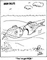
Walleye found in the Sturgeon Bay and Little Sturgeon area had 87% more PCBs than walleye from the western side of Green Bay at the mouth of the Oconto River. This fits what is known about the distribution of PCBs which spread from industries in the Fox River Valley.
Round gobies eat mussels off the rocky shoreline. In 2014 the state speargun record for the invasive round goby was taken by out of Door County waters on the Lake Michigan side. It weighed 5.0 ounces and was 8.25 inches long.
Lake whitefish and yellow perch are caught commercially. Lake whitefish are also caught commercially by ice fishing. Tagging studies have shown whitefish migrating from Big Bay de Noc which has less food to the plentiful waters off the peninsula.
Remains of sturgeon, catfish, sucker, smallmouth bass, white bass, walleye, and drum left behind by Native Americans were found near North Bay in the 1960s.
Surfing
Lake Michigan shoreline is used for lake surfing. One guidebook names the shore off Cave Point County Park as the best surfing area. Another water sport is windsurfing.
Climate
- Further information: Porte des Mortes#Climate
|
||||||||||||||||||||||||||||||||||||||||||||||||||||||||||||||||||||||||||||||||||||||||||||||||
Lake breeze
On hot summer days, cool lake breezes start in around noon and grow more intense by mid-afternoon. This effect can be noticed at the shoreline and around a mile or so inland. Although lake breezes are capable of penetrating considerably further inland, they are able to heat up quickly after passing onto land. After as little as a mile of travel inland, they may be nearly as warm as the air they push away. When a lake breeze encounters an inward curving shoreline, such as at Sister Bay, the breeze becomes more intense. The curve of the shore guides the breezes from opposing sides of the bay and makes them converge upon each other at the middle.
Rare snails
From 1996 to 2001, researchers identified 69 species of snails in Door County, the most out of the 22 counties in the study. Most of these were found on rock outcrop habitats. Ranking second was Brown County with 62 species. 48 species were found in Kewaunee County, ranking eighth. Slugs were found in all three counties. Peninsula State Park is home to the northernmost known population of Strobilops aenea. The species Vertigo hubrichti and Vertigo morsei are endemic to the upper Midwest. These two species had the highest occurrence frequencies along the Door and Garden Peninsulas. Door County is also home to several uncommon species from the genus Oxychilus, which is non-native and introduced from Europe. One was found near a vacation home and may have been introduced by landscape plantings. Within Door County, Brussels Hill, North Kangaroo Lake, Rock Island and the escarpment with its cool algific habitat supports populations of rare snails. Out of 63 locations in Door County where snails were found, the most species (28) were located on a cliff in Rock Island.
Images for kids
-
A comic drawn for the Door County Advocate in 1977 depicting a fish with PCBs.

