
Dorrigo, New South Wales facts for kids
Quick facts for kids DorrigoNew South Wales |
|||||||||
|---|---|---|---|---|---|---|---|---|---|

Dorrigo Main Square
|
|||||||||

Dorrigo
Location in New South Wales
|
|||||||||
| Population | 1,042 (2016 census) | ||||||||
| Postcode(s) | 2453 | ||||||||
| Elevation | 731 m (2,398 ft) | ||||||||
| Location |
|
||||||||
| LGA(s) | Bellingen Shire | ||||||||
| State electorate(s) | Oxley | ||||||||
| Federal Division(s) | Cowper | ||||||||
|
|||||||||
Dorrigo, a small town on the Waterfall Way, is located on the Northern Tablelands, in northern New South Wales, Australia. The town is part of Bellingen local government area.
It is approximately 580 kilometres (360 mi) north of the state capital, Sydney via the Pacific Highway, and 64 kilometres (40 mi) west from the coastal city of Coffs Harbour. The town is situated on the Dorrigo Plateau near the New England Escarpment, which is part of the Great Dividing Range. Dorrigo is 731 metres (2,398 ft) above sea level. At the 2016 census, Dorrigo had a population of 1,042 people.
Contents
History
The traditional custodians of the land that is now known as Dorrigo are the Aboriginal people of the Gumbaynggirr nation.
European settlement of the area followed on from the early timber cutters in the 1860s. The first official European in the district was Land Commissioner Oakes who sighted the mouth of the Bellinger River.
Dorrigo is derived from the Aboriginal word, dondorrigo, meaning "stringy-bark". For many decades it was believed that explorer and settler Major Edward Parke named the region after a Spanish General named Don Dorrigo with whom Peake fought in the Peninsula War.
By 1841, timber cutters had entered the Bellinger River searching for red cedar (Toona australis). They set up camps and moved from one stand of trees to the next.
Richard Craig, an escaped convict from the Moreton Bay Penal Settlement, was the first European to discover the Dorrigo Plateau, following the traditional indigenous route to Armidale from the Grafton area. Using his skills as a horseman, Craig travelled along the western side of the Nymboida River. Craig's track became a road, now roughly following the same path as the present Grafton to Armidale Road and travelling through the present day villages of Nymboida, Billy's Creek, Dundurrabin, Tyringham and Ebor. Timbergetters followed Craig through the sub tropical rainforest and many sawmills grew due to demand for timber, initially the highly prized Australian Red Cedar (Toona australis).
Today, the main access road traversing the plateau from east to west is the Waterfall Way. It was not until the 1860s that permanent settlement occurred in the district. The dairy industry became a mainstay of the Dorrigo Plateau and today tourism is becoming more important. On 23 December 1924, the Glenreagh to Dorrigo railway opened. Due to flood damage, the line closed on 28 October 1972.
On 31 October 2005, sixty-eight dairy cows, all in full milk, died on a farm at Fernbrook on the Waterfall Way near Dorrigo after being struck by lightning. Three others were paralysed for several hours but they later made a full recovery. The cows were sheltering under a tree when it was struck by lightning and the electricity spread onto the surrounding soil killing the animals.
Attractions
Dorrigo is home to the planned Dorrigo Steam Railway and Museum which is not yet open to the public. It houses the largest collection of railway vehicles and memorabilia from the various Government and private railways of New South Wales. It is one of the most comprehensive railway collections in the world, with items in the collection ranging from 1855 to the present day. The museum is not open to the public however the larger items such as steam engines and carriages can be viewed from outside the property. The nearby World Heritage listed Dorrigo National Park and New England National Park cater for persons interested in natural sights. A full listing of attractions are available here
Dangar Falls
Dangar Falls are located about 1.2 kilometres (0.75 mi) north of Dorrigo, on the Bielsdown River. The falls are small but picturesque, and are a popular photographic subject. For a short time after rain they are quite spectacular. There is an attractive picnic spot which offers excellent views. It is possible to climb down the banks and walk along the river below the water falls.
These falls are often confused with Dangars Falls, near Armidale, about 125 kilometres (78 mi) to the west, along the Waterfall Way. For more information about Dangars Falls see the articles on Dangarsleigh and on the Oxley Wild Rivers National Park.
Climate and weather
Dorrigo has an oceanic climate and, with an average annual rainfall of roughly 2,000mm, is the wettest town in New South Wales.
| Climate data for Dorrigo (Dorrigo Old Coramba Road, 1996-2013) | |||||||||||||
|---|---|---|---|---|---|---|---|---|---|---|---|---|---|
| Month | Jan | Feb | Mar | Apr | May | Jun | Jul | Aug | Sep | Oct | Nov | Dec | Year |
| Record high °C (°F) | 36.3 (97.3) |
35.6 (96.1) |
34.1 (93.4) |
28.0 (82.4) |
25.0 (77.0) |
23.5 (74.3) |
22.7 (72.9) |
29.5 (85.1) |
32.0 (89.6) |
34.6 (94.3) |
33.8 (92.8) |
34.5 (94.1) |
36.3 (97.3) |
| Average high °C (°F) | 24.0 (75.2) |
23.7 (74.7) |
22.3 (72.1) |
19.7 (67.5) |
16.9 (62.4) |
14.8 (58.6) |
14.3 (57.7) |
16.0 (60.8) |
19.3 (66.7) |
20.9 (69.6) |
21.8 (71.2) |
23.6 (74.5) |
19.8 (67.6) |
| Average low °C (°F) | 14.9 (58.8) |
15.0 (59.0) |
13.3 (55.9) |
10.6 (51.1) |
7.2 (45.0) |
5.2 (41.4) |
4.4 (39.9) |
4.7 (40.5) |
7.6 (45.7) |
9.7 (49.5) |
12.1 (53.8) |
13.8 (56.8) |
9.9 (49.8) |
| Record low °C (°F) | 7.5 (45.5) |
8.5 (47.3) |
6.0 (42.8) |
1.0 (33.8) |
−3.0 (26.6) |
−3.5 (25.7) |
−3.0 (26.6) |
−3.2 (26.2) |
−0.4 (31.3) |
−0.7 (30.7) |
3.9 (39.0) |
3.6 (38.5) |
−3.5 (25.7) |
| Average rainfall mm (inches) | 309.0 (12.17) |
288.7 (11.37) |
327.6 (12.90) |
140.9 (5.55) |
87.9 (3.46) |
135.4 (5.33) |
63.5 (2.50) |
102.6 (4.04) |
87.4 (3.44) |
117.5 (4.63) |
201.5 (7.93) |
168.3 (6.63) |
2,034.1 (80.08) |
| Average rainy days | 15.5 | 15.8 | 18.1 | 14.6 | 11.2 | 10.5 | 9.8 | 7.9 | 9.1 | 11.7 | 16.6 | 16.6 | 157.4 |
| Average relative humidity (%) | 73 | 75 | 75 | 73 | 68 | 65 | 60 | 55 | 57 | 61 | 70 | 70 | 67 |
| Source: Bureau of Meteorology | |||||||||||||
Significant weather events
On 19 October 1913, a severe hailstorm struck Dorrigo, where hail fell for an hour, with hail banked up in many places. The storm caused hundreds of pounds of damage. On 6 August 1923, the first known snowfall occurred at Dorrigo.
On 24 June 1950, 636.0 millimetres (25.04 in) of rain was recorded in the 24 hours to 9 am at Dorrigo Post Office. In the following 24 hours, to 9 am on 25 June 1950, a further 230.9 millimetres (9.09 in) of rain was recorded at the same site. On 21 February 1954, Dorrigo's highest daily rainfall (in the 24 hours to 9 am) of 809.2 millimetres (31.86 in) was recorded. This is also the highest daily rainfall total for anywhere in New South Wales. This was recorded at Myrtle Street in Dorrigo. Another Bureau of Meteorology site located at Dorrigo Post Office recorded 774.7 millimetres (30.50 in) of rain within the same 24-hour period to 9 am on 21 February 1954. These heavy rainfall totals were associated with a tropical cyclone which had crossed the coast at Coolangatta and Tweed Heads late on 20 February 1954.
Gallery
-
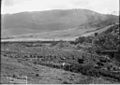
A Dorrigo homestead, circa 1900.
-
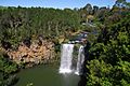
Dangar Falls at Dorrigo.
-
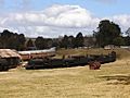
Engines and carriages on display outside the Dorrigo Steam Railway and Museum.


See also
 In Spanish: Dorrigo para niños
