
Douglas County, Kansas facts for kids
Quick facts for kids
Douglas County
|
|
|---|---|

Douglas County Courthouse in Lawrence
|
|

Location within the U.S. state of Kansas
|
|
 Kansas's location within the U.S. |
|
| Country | |
| State | |
| Founded | August 25, 1855 |
| Named for | Stephen Douglas |
| Seat | Lawrence |
| Largest city | Lawrence |
| Area | |
| • Total | 475 sq mi (1,230 km2) |
| • Land | 456 sq mi (1,180 km2) |
| • Water | 19 sq mi (50 km2) 4.0%% |
| Population
(2020)
|
|
| • Total | 118,785 |
| • Density | 260.5/sq mi (100.6/km2) |
| Time zone | UTC−6 (Central) |
| • Summer (DST) | UTC−5 (CDT) |
| Area code | 785 |
| Congressional district | 2nd |
Douglas County (county code DG) is located in the U.S. state of Kansas. As of the 2020 census, the county population was 118,785, making it the fifth-most populous county in Kansas. Its county seat and most populous city is Lawrence.
Contents
History
Early history
For many millennia, the Great Plains of North America was inhabited by nomadic Native Americans. From the 16th century to 18th century, the Kingdom of France claimed ownership of large parts of North America. In 1762, after the French and Indian War, France secretly ceded New France to Spain, per the Treaty of Fontainebleau.
19th century
In 1802, Spain returned most of the land to France, but keeping title to about 7,500 square miles. In 1803, most of the land for modern day Kansas was acquired by the United States from France as part of the 828,000 square mile Louisiana Purchase for 2.83 cents per acre.
In 1854, the Kansas Territory was organized, then in 1861 Kansas became the 34th U.S. state. In 1855, Douglas County was established. Douglas County was opened for settlement on May 15, 1854, and was named for Stephen A. Douglas, a senator from Illinois. The county was practically at the center of the Bleeding Kansas years as leaders in Lecompton, the territorial capital, wanted Kansas to be a slave state and leaders in Lawrence wanted Kansas to be a free state. Because of this, multiple events took place, including the drafting of the Lecompton Constitution admitting Kansas as a slave state, the sacking of Lawrence, and the Battle of Black Jack.
The first railroad in Douglas County, the Union Pacific, was built through that territory in 1864.
Geography
According to the U.S. Census Bureau, the county has a total area of 475 square miles (1,230 km2), of which 456 square miles (1,180 km2) is land and 19 square miles (49 km2) (4.0%) is water. It is the fifth-smallest county in Kansas by land area. Much of its northern boundary is defined by the Kansas River, which flows through Lawrence and provides hydropower at the Bowersock Dam.
Adjacent counties
- Jefferson County (north)
- Leavenworth County (northeast)
- Johnson County (east)
- Miami County (southeast)
- Franklin County (south)
- Osage County (southwest)
- Shawnee County (northwest)
Demographics
| Historical population | |||
|---|---|---|---|
| Census | Pop. | %± | |
| 1860 | 8,637 | — | |
| 1870 | 20,592 | 138.4% | |
| 1880 | 21,700 | 5.4% | |
| 1890 | 23,961 | 10.4% | |
| 1900 | 25,096 | 4.7% | |
| 1910 | 24,724 | −1.5% | |
| 1920 | 23,998 | −2.9% | |
| 1930 | 25,143 | 4.8% | |
| 1940 | 25,171 | 0.1% | |
| 1950 | 34,086 | 35.4% | |
| 1960 | 43,720 | 28.3% | |
| 1970 | 57,932 | 32.5% | |
| 1980 | 67,640 | 16.8% | |
| 1990 | 81,798 | 20.9% | |
| 2000 | 99,962 | 22.2% | |
| 2010 | 110,826 | 10.9% | |
| 2020 | 118,785 | 7.2% | |
| U.S. Decennial Census 1790-1960 1900-1990 1990-2000 2010-2020 |
|||

Douglas County comprises the Lawrence, KS Metropolitan Statistical Area, which is also included in the Kansas City-Overland Park-Kansas City, MO-KS Combined Statistical Area.
As of the 2000 census, there were 99,962 people, 38,486 households, and 21,167 families residing in the county. The population density was 219 people per square mile (84/km2). There were 40,250 housing units at an average density of 88 per square mile (34/km2). The racial makeup of the county was 86.1% White, 4.2% Black or African American, 2.6% Native American, 3.1% Asian, 0.1% Pacific Islander, 1.2% from other races, and 2.7% from two or more races. Hispanic or Latino of any race were 3.3% of the population.
There were 38,486 households, out of which 27.4% had children under the age of 18 living with them, 43.1% were married couples living together, 8.5% had a female householder with no husband present, and 45.0% were non-families. 28.5% of all households were made up of individuals, and 5.8% had someone living alone who was 65 years of age or older. The average household size was 2.37 and the average family size was 2.97.
In the county, the population was spread out, with 20.4% under the age of 18, 26.4% from 18 to 24, 28.3% from 25 to 44, 16.9% from 45 to 64, and 7.9% who were 65 years of age or older. The median age was 27 years. For every 100 females there were 98.70 males. For every 100 females age 18 and over, there were 97.70 males.
The median income for a household in the county was $37,547, and the median income for a family was $53,991. Males had a median income of $35,577 versus $27,225 for females. The per capita income for the county was $19,952. About 6.2% of families and 15.9% of the population were below the poverty line, including 9.0% of those under age 18 and 7.3% of those age 65 or over.
Transportation
Major highways

 I-70 / Kansas Turnpike, runs east to west just north of Lawrence.
 US-59 runs north to south through the middle of the county and the middle of Lawrence.
 US-40 virtually follows the Oregon Trail heading west out of Lawrence.
 US-56 runs east to west in the southern half of the county, going through Baldwin City and skirts the Santa Fe Trail.
 K-10 runs from the I-70 Lecompton Exchange along the south and west border of Lawrence to US-59 then north until 23rd Street where it heads east out of town into Johnson County.
Other major highways include:
 US-24 which is in Grant township leading from Leavenworth to Jefferson County.
 K-32 starts just outside Lawrence and leads into Leavenworth County.
 K-33 is in extreme southeast Douglas County and leads into Franklin County.
County Highways
Douglas County also maintains an extensive network of county highways to serve the rural areas of the county. None of these county highways is in the Lawrence city limits.
Parks
Clinton Lake, completed in 1980, offers boating, fishing and other water sports and various parks surrounding the lake provides camping and trails for mountain biking, hiking and horseback riding.
Lone Star Lake is a small country lake to the southwest of Lawrence offers fishing, boating and camping. Just northwest of Baldwin City is Douglas State Fishing Lake which provides hunting, fishing and limited camping. Other parks around the county include Black Jack Park which includes the Ivan Boyd Prairie Preserve and Robert Hall Pearson Memorial Park, Broken Arrow Park in Lawrence and Wells Overlook Park just south of Lawrence.
Events
Major events in the county include the Maple Leaf Festival in Baldwin City every third full weekend in October. Lecompton's Territorial Days take place every year in June and Lawrence has many parades throughout the year including Christmas and St. Patrick's Day.
Communities
Incorporated cities
Unincorporated communities
Townships
Douglas County is divided into nine townships. The city of Lawrence is considered governmentally independent and is excluded from the census figures for the townships. In the following table, the population center is the largest city (or cities) of significant size included in that township's population total.
| Township | FIPS | Population center |
Population | Population density /km² (/sq mi) |
Land area km² (sq mi) |
Water area km² (sq mi) |
Water % | Geographic coordinates |
|---|---|---|---|---|---|---|---|---|
| Clinton | 14325 | 531 | 7 (17) | 80 (31) | 26 (10) | 24.41% | 38°54′18″N 95°24′20″W / 38.90500°N 95.40556°W | |
| Eudora | 21700 | Eudora | 5,571 | 43 (113) | 128 (49) | 2 (1) | 1.57% | 38°55′42″N 95°6′15″W / 38.92833°N 95.10417°W |
| Grant | 27650 | 442 | 10 (27) | 43 (16) | 0 (0) | 0.74% | 39°0′8″N 95°13′19″W / 39.00222°N 95.22194°W | |
| Kanwaka | 36075 | 1,317 | 12 (30) | 114 (44) | 8 (3) | 6.69% | 38°57′37″N 95°23′16″W / 38.96028°N 95.38778°W | |
| Lecompton | 39175 | Lecompton | 1,761 | 20 (51) | 90 (35) | 2 (1) | 2.45% | 39°2′31″N 95°24′27″W / 39.04194°N 95.40750°W |
| Marion | 44700 | 836 | 5 (12) | 185 (72) | 1 (0) | 0.52% | 38°49′4″N 95°24′35″W / 38.81778°N 95.40972°W | |
| Palmyra | 54225 | Baldwin City | 5,760 | 27 (70) | 212 (82) | 2 (1) | 0.79% | 38°47′0″N 95°10′40″W / 38.78333°N 95.17778°W |
| Wakarusa | 74400 | 2,237 | 19 (49) | 119 (46) | 2 (1) | 1.81% | 38°55′49″N 95°14′43″W / 38.93028°N 95.24528°W | |
| Willow Springs | 79500 | 1,409 | 10 (26) | 141 (54) | 1 (0) | 0.54% | 38°47′23″N 95°18′17″W / 38.78972°N 95.30472°W | |
| Sources: | ||||||||
Historic Townships

The county originally had only four townships. Lecompton comprised the area of Lecompton, Kanwaka, and Clinton townships; Washington took the place of Marion and Willow Springs townships; Wakarusa comprised both Wakarusa and Eudora townships; and Calhoun was the original name of Palmyra township. Grant township was annexed from Jefferson County in 1874.
Education

Unified school districts
Douglas County is served by seven school districts.
- Lawrence USD 497 serves Lawrence, the Clinton Lake area, and parts of rural Douglas County that surround Lawrence.
- Eudora USD 491 serves Eudora and the northeast part of the county.
- Shawnee Heights USD 450 services the extreme western part of the county including Big Springs.
Universities and colleges
The University of Kansas's main campus is located in Lawrence, as is Haskell Indian Nations University. Baker University, the state's oldest university, is located in Baldwin City.
Notable people
- Isaac F. Hughes, Douglas County commissioner and City Council member in both Lawrence, Kansas, and Los Angeles, California.
Images for kids
-
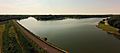
Lone Star Lake, which is in southwestern Douglas County.
-
map legend]])


See also
 In Spanish: Condado de Douglas (Kansas) para niños
