
Downtown Columbus, Ohio facts for kids
Quick facts for kids
Downtown Columbus
|
|
|---|---|

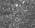
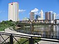
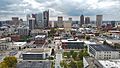
Downtown Columbus from the southwest in 2015
|
|
| Country | United States |
| State | Ohio |
| County | Franklin |
| City | Columbus |
| Population
(2019)
|
|
| • Total | 9,270 |
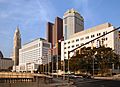
Downtown Columbus is the central business district of Columbus, Ohio. Downtown is centered on the intersection of Broad and High Streets, and encompasses all of the area inside the Inner Belt. Downtown is home to most of the tallest buildings in Columbus.
The state capitol, the Ohio Statehouse, is located in the center of downtown on Capitol Square. Downtown is also home to Columbus State Community College, Franklin University, Columbus College of Art and Design, Grant Medical Center, Capital University Law School, as well as the Main Library of the Columbus Metropolitan Library, the pioneering Main Street Bridge, and many parks.
Downtown has many neighborhoods or districts, but it can be separated into three main areas: the Discovery District, the High Street Corridor, and the Riverfront. Downtown also includes the Arena District, Capitol Square, and the Columbus Civic Center. The Short North, Italian Village, and Victorian Village are directly north of downtown. Olde Towne East and King-Lincoln Bronzeville are directly east, while the Brewery District and German Village are directly south of Downtown. Franklinton is to the west of downtown.
Almost 90,000 people are employed downtown, and more than 33,000 students attend school at one of the many institutions of higher education located there. As of 2022, Downtown is home to about 11,200 residents.
Contents
History
The city of Columbus began development in 1812 with the purpose of being the state's new capital. Originally laid out by Lucas Sullivant as the town of Franklinton, the original settlement lay west of the Scioto River. However, Sullivant laid out plans to expand east of the river for what we now know as downtown Columbus. Development began quickly and by 1814 significant buildings included a penitentiary, the first school, the statehouse, the first newspaper, and the first church. By 1816, Columbus was incorporated as an official town, and in 1824 Columbus became the official seat of the county and elected its first mayor, John Brooks, in 1834 after being elevated to "city" status. The city of Columbus has spread out and around from the original 10 acres (4.0 ha; 0.040 km2) plot surrounding the Statehouse, making downtown the literal center of the city. Another pivotal element of downtown Columbus is the Scioto River, which snakes directly through downtown. The downtown of Columbus has changed roles since its founding, going from a government center, to an industrial and commercial center, to what it currently is as the major commercial hub of central Ohio. The first skyscraper to adorn downtown Columbus' skyline is the LeVeque Tower, built in 1927. Many other high rises and skyscrapers have been added since the LeVeque Tower, fitting a variety of uses from commercial to residential.

Urban Renewal
In the early 1950s, major cities began revitalization projects of slums and blighted areas in their communities. Assisted by federal and state funding, these were intended to clear major slums in an effort to revitalize that area for the overall welfare of the city. In January 1952, the Department of Development for the city of Columbus began commissioning task forces in an effort for urban renewal in the blighted areas. The efforts of these task forces are evident in numerous older communities and districts, including Market Mohawk and German Village. Before this intervention in Market Mohawk, the annual tax return was $84,000. After revitalization efforts were made, the annual tax return was greater than $514,000.
Geography
Columbus' location was chosen based on its central location within the state of Ohio along with the confluence of the Scioto River and Olentangy River being right next to it. Originally, the area that is now Columbus was to be allotted to those displaced from Nova Scotia during the American Revolution, and the original settlement lay about a mile west of the Scioto River and the current downtown area. The center of downtown Columbus is focused on the intersection of Broad Street and High Street. The City of Columbus includes an area of around 225 square miles, but downtown is generally referred to as the area within the Scioto River, Interstate 70, Interstate 71, and Interstate 670. The last of these major highways, I-70, was completed in 1992. Downtown Columbus is bordered to the north by The Short North, to the northwest by Grandview Heights, to the southwest by Franklinton, to the south by German Village, and to the east by King-Lincoln Bronzeville. Downtown Columbus has five major neighborhoods that make up its diverse area.
Arena District

The Arena District sits on the northwest side of downtown Columbus, with its borders roughly being Nationwide Arena to the north, Front Street to the east, Spring Street to the south, and the Olentangy River to the west. The district is home to a few defining buildings, including Nationwide Arena, Huntington Park, and the LC Pavilion. Nationwide Arena is the home of the Columbus Blue Jackets, as well as a venue for a variety of other sporting and special events. Occasionally, the Ohio State University men's and women's basketball teams will also use the facility to host special games. Nationwide first began hosting concerts and hockey games in early 2000. Huntington Park is the home of the Columbus Clippers, which is a minor league affiliate team of the Cleveland Indians. Huntington Park was opened for games in spring 2009, making its debut in the Arena District. Huntington Park sits directly west of Nationwide Arena. The LC Pavilion (formerly the Promowest Pavilion) is the first dual indoor and outdoor concert venue in the country. The "LC", as it is known locally, as recently as 2013, was ranked by Billboard Magazine as 24th on their list of Hottest Small Venue Music Clubs in the nation. The LC hosts mainly musical acts, averaging just about 110 shows each year. The district also plays host to a variety of bars, restaurants, and cafes in the area. The district originally contained old industrial buildings, but began redevelopment in 1996 under then City Councilman Michael B. Coleman.
Discovery District

The Discovery District is the eastern district of downtown Columbus. Interstate 670 borders it to the North while Interstate 71, Fulton Street, and Fifth Street borders it to the East, South, and West, respectively. Within the Discovery District are buildings of culture, art, design, and education. Columbus Metropolitan Library and the Columbus Museum of Art are both located within the district. Also, there are numerous educational options within this district.Columbus State Community College is a two-year associates-degree institution located in the Discovery District with an enrollment of just under 25,000 students. Also located in the district are the Columbus College of Art and Design, which was founded in 1879 as the Columbus Art School and enrolls roughly 1,300 students, and the Capital University Law School. The ABA-accredited law school is a branch of Capital University in Bexley, Ohio. Within the Discovery District is The Discovery Special Improvement District. The goal of this private-sector corporation, that encompasses a 37 square block area, is to improve the safety and image for the Discovery District neighborhood.
River South District

The River South District is the southwest area of Downtown Columbus along the Scioto River that is surrounded by Town Street to the North, Mound Street to the South, The Scioto River to the West, and Wall Street to the East. One of the main attractions of the River South District is a 7 acres (2.8 ha; 0.028 km2) green space called Columbus Commons. Columbus Commons was built over the former site of City Center Mall in 2010 and includes within it the outdoor venue Bicentennial Pavilion. Another area of interest is The Scioto Mile which is a park that follows the riverfront of the Scioto River. Attractions along The Scioto Mile Include the Bicentennial Park and the River South Art Walk.
Uptown District (High Street Corridor)

The Uptown District, also known as the High Street Corridor, runs along High Street from Town Street in the south to the Greater Columbus Convention Center in the North. The Ohio Statehouse resides in the Uptown District, as well as a series of bars and restaurants to the north along Park Street. The Uptown District is also home to the Ohio Theatre, the Palace Theatre, and the Trinity Episcopal Church. LeVeque Tower, Columbus' first skyscraper, also resides in the Uptown District, west of the Ohio Statehouse and on the banks of the Scioto River.
Miranova Place District

Miranova Place is located within the southwestern corner of downtown. It is bordered by the Scioto River to the north and west, interstate 70 to the south, and South Civic Center Drive to the east. Within it lies two major features, the Miranova Condominiums and the Miranova Corporate Tower. The condominiums are a 26 floor residential unit that were finished in 2000. The Miranova Corporate Tower is a 12 floor corporate office space that was finished in 2001. The buildings designs reflect a modern architecture meant to serve as a bookend for downtown before it reached the Scioto River and I-70. The buildings are owned by developer Ron Pizutti, and serve currently as his headquarters. Miranova Place is also home to local restaurant M at Miranova.
Market Mohawk District

The Market Mohawk District is located in the southeastern section of downtown and is bordered to the north irregularly by Chapel, Town, and Main Streets, Livingston Avenue to the South, South Parsons Avenue to the East, and to the west South Third Street. The Market Mohawk District was originally a residential area of single family homes that became a mixed-land-use area as the city grew. With the unprecedented growth, Market Mohawk became overpopulated and grew into a slum. In the 1960s the area was part of the $43 million Market Mohawk Urban Renewal Project. The redevelopment brought facilities for Greyhound Lines, Franklin University, and several apartment complexes. Today the district is still home to Franklin University and also includes the Market Mohawk apartments building, The Ohio Democratic Party Building, The Ohio Republican Party Building, and Columbus Downtown High School, to name just a few buildings.
Park Street District (North Market Historic District)

Park Street District, also known as the North Market Historic Area, sits in the northernmost part of downtown Columbus. Sitting just north of the Arena District, it is bounded by Goodale Avenue to the north, Vine Street to the south, high street to the west, and Neil venue to the west. The area retains numerous physical characteristics from the early twentieth century when it served as a wholesale and manufacturing focal point just north of the Columbus Union Station. In 1980, revitalization focused on becoming an exciting area, restaurant, and entertainment center. It features the North Market, the only continued market of the four originals in Columbus. Numerous restaurants and bars extend off of Park Street, as well as offices and retail options in the area. Its name is derived from the Park Street that dissects the district.
Fort Hayes

The Fort Hayes area is primarily located within the boundaries of the I-670 loop northeast of downtown, primarily along Cleveland Avenue. It was sold by Robert A. Neil and his brother William to the state in order to build a United States barracks in the then northeastern part of the city. The facility was built, and by 1875 was re-purposed to be primarily a recruiting intake and training facility. It was originally called the Columbus Barracks until 1922, when it then became Fort Hayes, named after Governor and President Rutherford B. Hayes. By 1976, the military had largely abandoned the Fort Hayes facility. The Columbus Public Schools district purchased an area of 50 acres (20 ha; 0.20 km2) for $1 USD and established what is now known as the Fort Hayes Metropolitan Education Center. During the 1988–89 school year, the Fort Hayes Arts and Academic High School was created, and joined the Columbus Public Schools' excellently-rated programs. Notable buildings still present as of 2015 include Shot Tower, one of the most recognizable buildings due to its central tower, and the Fort Hayes Metropolitan Education Center, and a Columbus City Schools bus depot.
Civic Center

The Civic Center is part of the central hub of the city, encapsulating the homes of the city government. It is bounded to the north by Long Street, to the south by Broad Street, the east by Front Street, and the Scioto River to the west. Home to numerous city government buildings, the unprecedented growth of Columbus lead to a much needed expansion of the cities civic center. The city began renting office spaces, and started to plan for additions to increase the multitude of work spaces. The site encompasses 5.75 acres (2.33 ha; 0.0233 km2) of land in the western part of downtown. The space there is home to numerous important infrastructures, including the Columbus City Hall, the headquarters of the Columbus Police, and the John W. Bricker Federal Building.
Structures and Landmarks
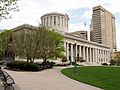
Ohio Statehouse

The construction of The Ohio Statehouse began in 1839 and would end in 1861. The building was designed in the Greek-Revival style by a group of architects, the most prominent of whom was Ohio-born Nathan B. Kelley. The Statehouse was built largely using Columbus Limestone taken from the banks of the Scioto River. The Statehouse was declared a National Historic Landmark by the Secretary of the U.S. Department of Interior.
Genoa Park
Named after the sister city in Italy, Genoa Park is a 2.07 acres (0.84 ha; 0.0084 km2) park located on Broad Street on the West Side of the Scioto River. Features include a riverfront amphitheater that holds events and concerts, Greenway Trail access, and a walking trail. The park is also in close proximity to the science entertainment center known as Cosi. The Park opened in 1999 and is also home to the Columbus Police Memorial.
Ohio Supreme Court Building
Now known as the Thomas J. Moyer Ohio Judicial Center, the Supreme Court Building was built in 1933 and has housed several departments of government throughout the years. Since 2004 it has been the location of the Ohio Supreme Court. The building is currently located on Front street and features several murals, bronze plaques, and statues which depict the history of Ohio.
McFerson Commons Park (Arch Park)

The McFerson Commons Park is a 2.21 acres (0.89 ha; 0.0089 km2) park that was developed after the demolition of the Ohio State Penitentiary. The park is named after the Nationwide Insurance CEO from 1992–2000, Dimon R. McFerson. The focal point of the park is the arch that was recovered from the Columbus Union Station after its demolition in 1979.
Residential

According to the 2010 census there were a total of 12,790 people living in the 43215 zip code which includes the downtown area as well as the area on the other side of the Scioto River in between State Route 315. Some of the residential buildings in downtown Columbus include Flats on Vine, Market-Mohawk Apartments, The Condominiums at North Bank Park, and Miranova Condominiums.
Infrastructure
Transportation
The main form of public transportation is the Central Ohio Transit Authority (COTA) bus system. Greyhound Lines also operates the Columbus Bus Station downtown. There are taxicabs and ridesharing companies such as Lyft and Uber. There are several interstates such as Interstate 70, Interstate 71, and Interstate 670 (Ohio) that run through downtown along with State Route 315. There are also bike lanes along several streets in downtown Columbus.
Food access
Downtown Columbus lacks a major commercial grocery store. Food insecurity is high for Downtown, rated as one of five zip codes with very low food security in Columbus. The Hills Market, an independent grocery for local and organic foods, is the only grocery in Downtown Columbus.
Gallery
-
An aerial photo of the area
-
Capitol Building
-
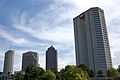
Columbus, Ohio Skyline
-
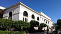
Columbus Museum of Art
-
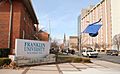
Franklin University
-
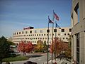
Columbus State Community College
-
Columbus Metropolitan Library
-
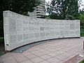
War memorial at the Ohio Statehouse
-
The Thurber House
-
Independence Day on Gay Street
-

Near Columbus College of Art & Design (CCAD)
-
AEP Building with William Green Building and 1 and 3 Nationwide Plaza
-
Columbus Ohio Former School for Deaf
-
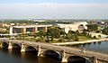
View from North Bank Park
-
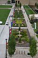
Columbus Commons Gardens
-
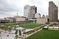
Columbus Commons
-
COSI
-
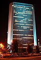
Nationwide Headquarters at One Nationwide Plaza
-
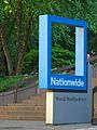
Nationwide Logo on Nationwide Plaza
-
William Green Building and Three Nationwide Plaza


Economy
There are several large businesses and organizations that operate out of downtown Columbus. Companies such as Nationwide, AEP, Huntington, and PNC all have buildings in downtown Columbus. The only mainstream daily newspaper in Columbus, The Columbus Dispatch, is headquartered in downtown Columbus on Broad Street. Along with many bars and restaurants, there are several venues that attract visitors to the downtown area, such as Nationwide Arena, Greater Columbus Convention Center, and the Lifestyle Communities Pavilion.
Demographics
According to the 2019 estimates there are a total of 18,660 people living in the 43215 zip code (which includes the downtown area as well as East Franklinton), up 46% from the 2010 census.
Images for kids
-
Western portion of downtown from the Discovery District
-
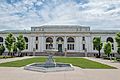
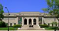
The Columbus Metropolitan Library's Main Library
-
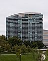
Miranova Condominiums
-
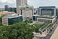
Municipal offices: 77 N. Front St., CPD headquarters, and the Coleman Government Center around the City Commons park
-
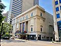
The Ohio Theatre


