Dungannon and South Tyrone Borough Council facts for kids
Quick facts for kids Dungannon and South Tyrone Borough Council |
|
|---|---|
 |
|
| Area | 315 km2 (122 sq mi) Ranked 5th of 26 |
| District HQ | Dungannon |
| Catholic | 64.1% |
| Protestant | 33% |
| Country | Northern Ireland |
| Sovereign state | United Kingdom |
| EU Parliament | Northern Ireland |
| Councillors |
|
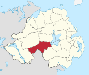
Dungannon and South Tyrone Borough Council (Irish: Comhairle Buirge Dhún Geanainn agus Thír Eoghain Theas, Ulster Scots: Rathgannon an Sooth Owenslanngh Cooncil) was a local council in Northern Ireland from 1973 until 2015. It was originally named Dungannon District Council, gaining borough status and adding "South Tyrone" to its name on 25 November 1999, after petitioning the Secretary of State for the Environment. In May 2015, under local government reorganisation in Northern Ireland it merged with Cookstown District Council and Magherafelt District Council to become Mid-Ulster District Council.
Review of Public Administration
Under the Review of Public Administration (RPA) the council is due to merge with Magherafelt District Council and Cookstown District Council in 2011 to form a single council for the enlarged area totalling 1714 km² and a population of 120, 096. The next election was due to take place in May 2009, but on 25 April 2008, Shaun Woodward, Secretary of State for Northern Ireland announced that the scheduled 2009 district council elections were to be postponed until the introduction of the eleven new councils in 2011.
Population
The area covered by Dungannon and South Tyrone Borough Council has a population of 57,852 residents according to the 2011 Northern Ireland census.

