
Dutchess County, New York facts for kids
Quick facts for kids
Dutchess County
|
|||
|---|---|---|---|

Main Mall Row, Poughkeepsie
|
|||
|
|||

Location within the U.S. state of New York
|
|||
 New York's location within the U.S. |
|||
| Country | |||
| State | |||
| Founded | 1713 | ||
| Named for | Mary of Modena, Duchess of York | ||
| Seat | Poughkeepsie | ||
| Largest city | Poughkeepsie | ||
| Area | |||
| • Total | 825 sq mi (2,140 km2) | ||
| • Land | 796 sq mi (2,060 km2) | ||
| • Water | 30 sq mi (80 km2) | ||
| Population
(2020)
|
|||
| • Total | 295,911 | ||
| • Density | 371.9/sq mi (143.6/km2) | ||
| Time zone | UTC−5 (Eastern) | ||
| • Summer (DST) | UTC−4 (EDT) | ||
| Congressional districts | 18th, 19th | ||


Dutchess County is a county in the U.S. state of New York. As of the 2020 census, the population was 295,911. The county seat is the city of Poughkeepsie. The county was created in 1683, one of New York's first twelve counties, and later organized in 1713. It is located in the Mid-Hudson Region of the Hudson Valley, north of New York City.
Dutchess County is part of the Poughkeepsie–Newburgh–Middletown Metropolitan Statistical Area, which belongs to the larger New York–Newark–Bridgeport, NY-NJ-CT-PA Combined Statistical Area.
Contents
History


Prior to Anglo-Dutch settlement, what is today Dutchess County was a leading center for the native Wappinger peoples. They had their council-fire at what is now present-day Fishkill Hook, and also held gatherings along the Danskammer. On November 1, 1683, the Province of New York established its first twelve counties, with Dutchess County being one of them. Its boundaries at that time included the present Putnam County, and a small portion of the present Columbia County (the towns of Clermont and Germantown). The county was named for Mary of Modena, Duchess of York, second wife of James, Duke of York (later James II, King of England). Dutchess is an archaic form of the word duchess.

The Province of New York and the Connecticut Colony negotiated an agreement on November 28, 1683, establishing their border as 20 miles (32 km) east of the Hudson River, north to Massachusetts. The 61,660 acres (249.5 km2) east of the Byram River making up the Connecticut Panhandle were granted to Connecticut, in recognition of the wishes of the residents. In exchange, Rye was granted to New York, along with a 1.81-mile (2.91 km) wide strip of land running north from Ridgefield to Massachusetts alongside the New York counties of Westchester, Putnam then Dutchess, known as "The Oblong". The eastern half of the stub of land in northeast Dutchess County containing Rudd Pond and Taconic State Park is the northernmost extension of The Oblong.
Until 1713, Dutchess was administered by Ulster County. On October 23, 1713 Queen Anne gave permission for Dutchess County to elect its own officers from among their own population including a Supervisor, Tax Collector, Tax Assessor and Treasurer. In 2013, Dutchess County celebrated its 300th anniversary of democracy based upon a legislative resolution sponsored by County Legislator Michael Kelsey from Salt Point. In 1812, Putnam County was detached from Dutchess.
The patents
.png)
In the twelve years 1685–1697 lawful patents had been granted securing for their purchasers every foot of Hudson River shoreline in the original county. Three additional patents, to 1706, laid claim to the remaining interior lands.
- 1685 Rombout (Beacon/Fishkill Area)
- 1686 Minnisinck (Sanders & Harmense)
- 1686 Kip
- 1688 Schuyler (Poughkeepsie)
- 1688 Schuyler (Red Hook)
- 1688 Ærtsen-Roosa-Elton
- 1696 Pawling-Staats
- 1697 Rhinebeck
- 1697 (Great) Nine Partners
- 1697 Philipse Patent
- 1697 Cuyler
- 1703 Fanconnier
- 1703 Beekman (Back Lots)
- 1706 (Little) Nine Partners
Early settlement
From 1683 to 1715 most of the settlers in Dutchess County were Dutch. Many of these moved in from Albany and Ulster Counties. They settled along the Fishkill River and in the areas that are now Poughkeepsie and Rhinebeck.
From 1715 to 1730 most of the new settlers in Dutchess county were Germans. From 1730 until 1775 New Englanders were the main new settlers in Dutchess County.
20th century
Franklin D. Roosevelt lived in his family home in Hyde Park, overlooking the Hudson River. His family's home is now the Home of Franklin D. Roosevelt National Historic Site, managed by the National Park Service.
Prior to the 1960s, Dutchess County was primarily agricultural. Since then the southwestern part (from Poughkeepsie southward and from the Taconic State Parkway westward) of the county has developed into a largely residential area, suburban in character, with many of its residents commuting to jobs in New York City and Westchester County. The northern and eastern regions of the county remain rural with large farmlands but at the same time developed residences used during the summer and or on weekends by people living in the New York City urban area.
Geography
According to the U.S. Census Bureau, the county has a total area of 825 square miles (2,140 km2), of which 796 square miles (2,060 km2) is land and 30 square miles (78 km2) (3.6%) is water.
Dutchess County is located in southeastern New York State, between the Hudson River on its west and the New York–Connecticut border on its east, about halfway between the cities of Albany and New York City. It contains two cities: Beacon and Poughkeepsie. Depending on precise location within the county, road travel distance to New York City ranges between 58 miles (93 km) and 110 miles (180 km).
The terrain of the county is mostly hilly, especially in the Hudson Highlands in the southwestern corner and the Taconic Mountains to the northeast. Some areas nearer the river are flatter.
The highest point in the county is the summit of Brace Mountain, in the Taconics, at 2,311 feet (704 m) above sea level. The lowest point is sea level, along the Hudson River.
Almost a half mile long border exists with Berkshire County, Massachusetts in the extreme northern end of the county.
Adjacent counties
- Columbia County – north
- Berkshire County, Massachusetts – northeast
- Litchfield County, Connecticut – east
- Fairfield County, Connecticut – southeast
- Putnam County – south
- Orange County – southwest
- Ulster County – west
National protected areas
- Eleanor Roosevelt National Historic Site
- Home of Franklin D. Roosevelt National Historic Site
- Vanderbilt Mansion National Historic Site
State, county, and town parks
- Bowdoin County Park
- Hudson Highlands State Park
- Stratt Town Park
- Wilcox County Park
- Tymor Forest
- Taconic State Park
- Beekman Rec
- East Fishkill Rec
- James Baird State Park
- Poughkeepsie Bridge (Walkway over the Hudson)
- Dover Stone Church
- Carnwath Farms Historic Site & Park
- Roosevelt Farm Lane
Demographics
| Historical population | |||
|---|---|---|---|
| Census | Pop. | %± | |
| 1790 | 45,276 | — | |
| 1800 | 47,775 | 5.5% | |
| 1810 | 51,363 | 7.5% | |
| 1820 | 46,615 | −9.2% | |
| 1830 | 50,926 | 9.2% | |
| 1840 | 52,398 | 2.9% | |
| 1850 | 58,992 | 12.6% | |
| 1860 | 64,941 | 10.1% | |
| 1870 | 74,041 | 14.0% | |
| 1880 | 79,184 | 6.9% | |
| 1890 | 77,879 | −1.6% | |
| 1900 | 81,670 | 4.9% | |
| 1910 | 87,661 | 7.3% | |
| 1920 | 91,747 | 4.7% | |
| 1930 | 105,462 | 14.9% | |
| 1940 | 120,542 | 14.3% | |
| 1950 | 136,781 | 13.5% | |
| 1960 | 176,008 | 28.7% | |
| 1970 | 222,295 | 26.3% | |
| 1980 | 245,055 | 10.2% | |
| 1990 | 259,462 | 5.9% | |
| 2000 | 280,150 | 8.0% | |
| 2010 | 297,488 | 6.2% | |
| 2020 | 295,911 | −0.5% | |
| U.S. Decennial Census 1790–1960 1900–1990 1990–2000 2010–2020 |
|||
As of the census of 2000, there were 280,150 people, 99,536 households, and 69,177 families residing in the county. The population density was 350 people per square mile (135/km2). There were 106,103 housing units at an average density of 132 per square mile (51/km2). 22.0% of the population was of Italian, 16.9% Irish, 11.3% German and 6.7% English ancestry according to Census 2000. 88.3% spoke English and 4.8% spoke Spanish.
Based on the Census Ancestry tallies, including people who listed more than one ancestry, Italians were the largest group in Dutchess County with 60,645. Irish came in a very close second at 59,991. In third place were the 44,915 Germans who barely exceeded the 44,078 people not in the 105 specifically delineated ancestry groups.
There were 99,536 households, out of which 34.5% had children under the age of 18 living with them, 55.5% were married couples living together, 10.3% had a female householder with no husband present, and 30.5% were non-families. 24.6% of all households were made up of individuals, and 9.0% had someone living alone who was 65 years of age or older. The average household size was 2.63 and the average family size was 3.16.
As of Q4 2021, the median home value in Dutchess County was $365,199, an increase of 13.8% from the prior year.
In the county, the age distribution of the population shows 25.1% under the age of 18, 9.4% from 18 to 24, 30.2% from 25 to 44, 23.2% from 45 to 64, and 12.0% who were 65 years of age or older. The median age was 37 years. For every 100 females, there were 100.1 males. For every 100 females age 18 and over, there were 98.2 males.
The median income for a household in the county was $53,086, and the median income for a family was $63,254. Males had a median income of $45,576 versus $30,706 for females. The per capita income for the county was $23,940. About 5.0% of families and 7.5% of the population were below the poverty line, including 8.5% of those under age 18 and 6.5% of those age 65 or over.
The decrease in population between 1810 and 1820 was due to the separation of Putnam County from Dutchess in 1812.
Racial demographics
As of 2017, the residents of Dutchess County were reported as the following: American Indian and Alaska Native (0.04%), Asian (4%), Black or African American (8.5%), Hispanic or Latino (12.5%), Native Hawaiian and Other Pacific Islander (0.016%), Some Other Race (0.35%), Two or More Races (3%), White (71%).

Law enforcement
The Cities of Beacon and Poughkeepsie; Towns of Fishkill, Hyde Park, Pine Plains, Poughkeepsie, Rhinebeck, Red Hook, and East Fishkill; and Villages of Millerton, Wappingers Falls, Millbrook, have their own Police departments. The remainder of the county is patrolled by the Dutchess County Sheriff's Office and New York State Police. The New York State Police Troop K headquarters is located in Millbrook.
Elections
| Year | Republican | Democratic |
|---|---|---|
| 2016 | 47.2% 61,797 | 47.6% 62,261 |
| 2012 | 45.3% 56,025 | 52.8% 65,312 |
| 2008 | 45.1% 59,628 | 53.7% 71,060 |
| 2004 | 51.2% 63,372 | 47.0% 58,232 |
| 2000 | 47.1% 52,669 | 46.9% 52,390 |
| 1996 | 40.4% 41,929 | 45.6% 47,339 |
| 1992 | 40.5% 46,709 | 36.1% 41,655 |
| 1988 | 61.0% 62,165 | 38.2% 38,968 |
| 1984 | 67.9% 70,324 | 31.7% 32,867 |
| 1980 | 57.6% 53,616 | 30.8% 28,616 |
| 1976 | 56.9% 51,312 | 41.6% 37,531 |
| 1972 | 69.8% 64,864 | 30.0% 27,872 |
| 1968 | 54.9% 45,032 | 37.8% 31,025 |
| 1964 | 37.0% 29,503 | 62.9% 50,179 |
| 1960 | 60.7% 46,109 | 39.3% 29,842 |
The current composition of the County Legislature is 16 Republicans, 7 Democrats, and 2 Independents. The current county executive is Republican Marcus Molinaro. The county executive is elected in a countywide vote. The majority of the county is located in New York's 19th congressional district, which is currently being represented by Republican John Faso. Dutchess County has historically leaned Republican due to its affluence and large suburban swaths; it has voted for Democratic presidential candidates only five times – 1964, 1996, 2008, 2012, and 2016. The largely suburban southern towns of Dutchess tend to be more conservative, while the small villages and rural areas of the northern tier have become somewhat more liberal. Almost all elected officials are Republican, but in the 2012 Presidential Election, Barack Obama carried Dutchess with 53% of the vote.
| Name | Party | Term |
|---|---|---|
| David C. Schoentag | Republican | January 1, 1968 – December 31, 1975 |
| Edward C. Scheuler | Republican | January 1, 1976 – April, 1978 |
| Lucille P. Pattison | Democrat | January 1, 1979 – December 31, 1991 |
| William R. Steinhaus | Republican | January 1, 1992 – December 31, 2011 |
| Marcus Molinaro | Republican | January 1, 2012 – |
| District | Legislator | Title | Party | Residence |
|---|---|---|---|---|
| 1 | Ellen Nesbitt | Republican | Poughkeepsie | |
| 2 | Don Sagliano | Republican | Pleasant Valley | |
| 3 | Dale L. Borchert | Chairman | Republican | Poughkeepsie |
| 4 | Hannah Black | Democrat | Hyde Park | |
| 5 | Kenneth Roman | Republican | Poughkeepsie | |
| 6 | Angela E. Flesland | Republican | Poughkeepsie | |
| 7 | Will Truitt | Republican | Hyde Park | |
| 8 | Craig P. Brendli | Democrat | Poughkeepsie | |
| 9 | Kari Rieser | Democrat | Poughkeepsie | |
| 10 | Barbara Jeter-Jackson | Democrat | Poughkeepsie | |
| 11 | Joel Tyner | Democrat | Staatsburg | |
| 12 | John D. Metzger | Republican | Hopewell Junction | |
| 13 | Donna Bolner | Assistant Majority Leader | Republican | LaGrangeville |
| 14 | Francena I. Amparo | Assistant Minority Leader | Democrat | Wappingers Falls |
| 15 | Joseph Incoronato | Republican | Wappingers Falls | |
| 16 | John V. Forman | Independent | Hopewell Junction | |
| 17 | James J. Miccio | Majority Leader | Republican | Fishkill |
| 18 | Jerry Landisi | Independent | Beacon | |
| 19 | A. Gregg Pulver | Republican | Pine Plains | |
| 20 | Micki Strawinski | Minority Leader | Democrat | Rhinebeck |
| 21 | Marge J. Horton | Republican | Hopewell Junction | |
| 22 | Marc Coviello | Republican | Poughquag | |
| 23 | John M. Thomes | Republican | Pawling | |
| 24 | Alan V. Surman | Republican | Pawling | |
| 25 | Sandy Washburn | Republican | Salt Point |
Transportation
Roads

- Interstate 84 traverses the county in an east–west route cutting through the southwestern quadrant of the county before entering Putnam County. It is the only interstate highway in the county.
- US 9, the Taconic State Parkway (the only other limited-access road in the county besides I-84, although it still has some at-grade intersections), and NY 22 are the main north–south roads in the county. For much of its length the Taconic is paralleled by NY 82. NY 9G leaves US 9 in Poughkeepsie and parallels it north to the Columbia County line.
- US 44, NY 52, NY 55, and NY 199 are the other primary east–west roads in the county. NY 52 enters the county concurrent with I-84, leaves it at Fishkill but then follows it into Putnam County.
Crossings
Three spans cross the Hudson River, linking Dutchess with Orange, Ulster, and Greene Counties:
- The Newburgh-Beacon Bridge carries Interstate 84 and NY 52 between Fishkill/Beacon and Newburgh (Orange County). The westbound span opened in 1963 and the eastbound span opened in 1980.
- The Mid-Hudson Bridge carries US 44 and NY 55 between Poughkeepsie and Highland (Town of Lloyd, Ulster County)
- The Kingston-Rhinecliff Bridge carries NY 199 between Rhinebeck and Kingston (Ulster County)
Railroads

The Metro-North railroad provides a critical link to New York City for Dutchess County's commuting population. The Hudson Line and Amtrak run concurrently along the Hudson River, on the western edge of the county. The Hudson Line has stops at Breakneck Ridge, Beacon, and New Hamburg (a hamlet of the town of Poughkeepsie) before the Hudson Line terminates at Poughkeepsie. The tracks continue north of that point as Amtrak, with Poughkeepsie and Rhinecliff (a small hamlet in the Town of Rhinebeck) being stops along Amtrak's Empire Service.
The Harlem Line, on the eastern side of the county, has station stops in Pawling, along the Appalachian Trail, Wingdale, Dover Plains, and two stops in Wassaic (one along the Tenmile River and the other the namesake terminus of that line).
Buses and Ferries

Public transportation in Dutchess County is handled by Dutchess County Public Transit, commonly called "the LOOP." Outside of the urbanized area of the county, most service is limited. Privately run lines connect Poughkeepsie to New Paltz and Beacon to Newburgh. Leprechaun Lines and Short Line Bus also operate some service through Poughkeepsie, Rhinebeck, and the southern part of the county.
NY Waterway operates the Newburgh–Beacon Ferry, which is located at the Beacon train station.
Air
General aviation facilities are located at Hudson Valley Regional Airport (formerly Dutchess County Airport), located in Wappinger and Sky Park Airport in Red Hook, New York. General commercial passenger service is provided by New York Stewart International Airport, which is located across the Hudson River in Newburgh.

Culture
Dutchess County Chamber of Commerce holds an annual hot air balloon launch typically in the first week of July. The main launch sites are along the Hudson River. As many as 20 balloons participate in the event.
Communities
N.B.: Cities, Towns and Villages are official political designations.
| Dutchess County, New York |
|---|
 |
Cities
- Beacon
- Poughkeepsie (county seat)
Towns
Villages
Hamlets
- Amenia
- Annandale-on-Hudson
- Arlington
- Arthursburg
- Attlebury
- Bangall
- Bear Market
- Brinckerhoff
- Barnegat
- Barrytown
- Crown Heights
- De Witt Mills
- Dover Plains
- Fairview
- Fishkill Plains
- Freedom Plains
- Gayhead
- Glenham
- Gretna
- Haviland
- Hillside Lake
- Holmes
- Hopewell Junction
- Hortontown
- Hughsonville
- Hyde Park
- Johnsontown
- Knapps Corner
- Lomala
- McIntyre
- Merritt Park
- Millbrook
- Myers Corner
- New Hackensack
- New Hamburg
- Norrie Heights
- Oniontown
- Pecksville
- Pine Plains
- Pleasant Plains
- Pleasant Valley
- Poughquag
- Red Oaks Mill
- Rhinecliff
- Rudco
- Salt Point
- Shenandoah
- Shekomeko
- Spackenkill
- Staatsburg
- Stanfordville
- Stissing
- Stormville
- Swartwoutville
- Titusville
- Wassaic
- Washington Hollow
- Wiccopee
- Willow Brook
- Wingdale
- Van Keurens
- Verbank
Sports
The Hudson Valley Renegades are a minor league baseball team affiliated with the New York Yankees. The team is a member of the High-A East, and play at Dutchess Stadium in Fishkill.
The Hudson Valley Bears were one of four founding members of the Eastern Professional Hockey League (EPHL). They played their home games at the Mid-Hudson Civic Center in Poughkeepsie.
The Hudson Valley Hawks was a team in the former National Professional Basketball League. The team's home court was at Beacon High School, in Beacon.
Education
Public school districts
- Arlington Central School District
- Beacon City School District
- Dover Union Free School District
- Hyde Park Central School District
- Millbrook Central School District
- Pawling Central School District
- Pine Plains Central School District
- Poughkeepsie City School District
- Red Hook Central School District
- Rhinebeck Central School District
- Spackenkill Union Free School District
- Wappingers Central School District
- Webutuck Central School District
- Dutchess County BOCES
Private schools
- Dutchess Day School
- Hawk Meadow Montessori School
- Holy Trinity School
- Millbrook School
- Oakwood Friends School
- Our Lady of Lourdes High School
- Poughkeepsie Day School
- Randolph School
- St. Denis-St. Columba School
- St. Martin de Porres School
- St. Mary School - Fishkill
- Trinity-Pawling School
- Tabernacle Christian Academy
- Upton Lake Christian School
Higher education
- Bard College (Annandale-on-Hudson)
- Culinary Institute of America main campus (Hyde Park)
- Dutchess Community College (Poughkeepsie)
- Marist College (Poughkeepsie)
- Vassar College (Poughkeepsie)
Images for kids
-
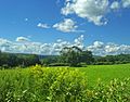
View of Harlem Valley from Appalachian Trail in Pawling
-
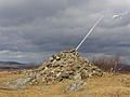
Summit of Brace Mountain, the highest point in Dutchess County


See also
 In Spanish: Condado de Dutchess para niños
