
Dyer County, Tennessee facts for kids
Quick facts for kids
Dyer County
|
|
|---|---|

Dyer County Courthouse in Dyersburg
|
|

Location within the U.S. state of Tennessee
|
|
 Tennessee's location within the U.S. |
|
| Country | |
| State | |
| Founded | 1823 |
| Named for | Robert Henry Dyer, state legislator |
| Seat | Dyersburg |
| Largest city | Dyersburg |
| Area | |
| • Total | 527 sq mi (1,360 km2) |
| • Land | 512 sq mi (1,330 km2) |
| • Water | 14 sq mi (40 km2) 2.7%% |
| Population
(2020)
|
|
| • Total | 36,801 |
| • Density | 75/sq mi (29/km2) |
| Time zone | UTC−6 (Central) |
| • Summer (DST) | UTC−5 (CDT) |
| Congressional district | 8th |
Dyer County is a county located in the westernmost part of the U.S. state of Tennessee. As of the 2020 census, the population was 36,801. The county seat is Dyersburg. Dyer County comprises the Dyersburg, TN Micropolitan Statistical Area.
Contents
History
Dyer County was founded by a Private Act of Tennessee, passed on October 16, 1823. The area was part of the territory in Tennessee that was previously legally occupied by Chickasaw Native American people ("Indian Lands").
The county was named for Robert Henry Dyer (circa 1774—1826). Dyer had been an army officer in the Creek War and War of 1812, and a cavalry colonel in the First Seminole War of 1818 before becoming a state senator. He was instrumental in the formation of the counties of Dyer and Madison County, Tennessee.
On April 2, 2006 a severe weather system passed through Dyer County, producing tornadoes that killed 16 in the county and 24 in Tennessee.
Geography
According to the U.S. Census Bureau, the county has a total area of 527 square miles (1,360 km2), of which 512 square miles (1,330 km2) is land and 14 square miles (36 km2) (2.7%) is water.
The county is drained by the Mississippi River, which forms its western boundary. It is in the part of Tennessee called the "Mississippi bottomland".
Dyer County is bisected by U.S. Route 51, the older major highway connecting Memphis with Chicago from south to north. When upgraded to interstate standards, this road will become Interstate 69. To the west, Dyer County is connected to Missouri by Interstate 155 over the Mississippi River, providing the only highway connection, other than those at Memphis, between Tennessee and the states to the west of the river.
Adjacent counties
- Lake County (north)
- Obion County (northeast)
- Gibson County (east)
- Crockett County (southeast)
- Lauderdale County (south)
- Mississippi County, Arkansas (southwest)
- Pemiscot County, Missouri (northwest)
State protected areas
- Bogota Wildlife Management Area
- Moss Island Wildlife Management Area
- Ernest Rice Wildlife Management Area
- Thorny Cypress Wildlife Management Area
- Tigrett Wildlife Management Area (part)
- Tumbleweed Wildlife Management Area (part)
- White Lake Refuge
Major Highways
 I-155
I-155 US 51
US 51 US 412
 SR 78
SR 78 SR 104
 SR 210
 SR 211
Demographics
| Historical population | |||
|---|---|---|---|
| Census | Pop. | %± | |
| 1830 | 1,904 | — | |
| 1840 | 4,484 | 135.5% | |
| 1850 | 6,361 | 41.9% | |
| 1860 | 10,536 | 65.6% | |
| 1870 | 13,706 | 30.1% | |
| 1880 | 15,118 | 10.3% | |
| 1890 | 19,878 | 31.5% | |
| 1900 | 23,776 | 19.6% | |
| 1910 | 27,721 | 16.6% | |
| 1920 | 29,983 | 8.2% | |
| 1930 | 31,405 | 4.7% | |
| 1940 | 34,920 | 11.2% | |
| 1950 | 33,473 | −4.1% | |
| 1960 | 29,537 | −11.8% | |
| 1970 | 30,427 | 3.0% | |
| 1980 | 34,663 | 13.9% | |
| 1990 | 34,854 | 0.6% | |
| 2000 | 37,279 | 7.0% | |
| 2010 | 38,335 | 2.8% | |
| 2020 | 36,801 | −4.0% | |
| U.S. Decennial Census 1790–1960 1900–1990 1990–2000 2010–2014 |
|||

2020 census
| Race | Num. | Perc. |
|---|---|---|
| White (non-Hispanic) | 28,272 | 76.82% |
| Black or African American (non-Hispanic) | 5,335 | 14.5% |
| Native American | 81 | 0.22% |
| Asian | 213 | 0.58% |
| Pacific Islander | 11 | 0.03% |
| Other/Mixed | 1,586 | 4.31% |
| Hispanic or Latino | 1,303 | 3.54% |
As of the 2020 United States census, there were 36,801 people, 15,120 households, and 10,566 families residing in the county.
Communities
City
Dyersburg (county seat)
- Bruce
- Edinburgh
- Gardner Heights
- Lakewood
- Lattawoods
- Milltown
- Pioneer
- Southtown
- The Farms
- Twin Oaks
- Pill Hill
Towns
Newbern
- Crowne Point
- Flower Valley
- Oakview
Trimble (partial)
Unincorporated communities
Civil Districts from 1920 Census
- District 1 - Tigrett
- District 2 - Bonicord
- District 3 - Bruceville
- District 4 - Dyersburg
- District 5 - Hurricane Hill, Millsfield, Nauvoo
- District 6 - Newbern
- District 7 - RoEllen
- District 8 - Tatumville
- District 9 - Churchton, Edgewood, Templeton
- District 10 - Finley, Richwood
- District 11 - Chic, Midway
- District 12 - Fowlkes
- District 13 - Unionville
- District 14 - Rushsbough, Tigertail
- District 15 - Trimble
- District 16 - Bogota, Miston
- District 17 - Lenox
- District 18 - Tannemo
- District 19 - Booths Point, Heloise
- District 20 - Lane
Images for kids
-
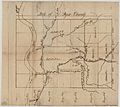
Map of Dyer County, Tennessee (1836)
.jpg)
See also
 In Spanish: Condado de Dyer para niños
