
Eagle Pass, Texas facts for kids
Quick facts for kids
Eagle Pass, Texas
|
|
|---|---|
 |
|
| Nicknames:
El Aguilón
El Paso del Aguila |
|

Location of Eagle Pass, Texas
|
|
| Country | |
| State | |
| County | Maverick |
| Government | |
| • Type | Council-Manager |
| Area | |
| • Total | 9.49 sq mi (24.58 km2) |
| • Land | 9.42 sq mi (24.40 km2) |
| • Water | 0.07 sq mi (0.18 km2) |
| Elevation | 732 ft (223 m) |
| Population
(2010)
|
|
| • Total | 26,248 |
| • Estimate
(2019)
|
29,684 |
| • Density | 3,150.83/sq mi (1,216.59/km2) |
| Time zone | UTC-6 (Central (CST)) |
| • Summer (DST) | UTC-5 (CDT) |
| ZIP codes |
78852-78853
|
| Area code(s) | 830 |
| FIPS code | 48-21892 |
| GNIS feature ID | 1356538 |
Eagle Pass is a city in and the county seat of Maverick County in the U.S. state of Texas. Its population was 26,255 as of the 2010 census (2019 estimate 29,684).
Eagle Pass borders the city of Piedras Negras, Coahuila, Mexico, which is to the southwest and across the Rio Grande. The Eagle Pass-Piedras Negras metropolitan area (EG-PN) is one of six binational metropolitan areas along the United States-Mexican border. As of January 2008, according to the US census, the EGPN's population was 48,401 people, and the Piedras Negras metropolitan area's population was 169,771.
Contents
History
Eagle Pass was the first American settlement on the Rio Grande. Originally known as Camp Eagle Pass, it served as a temporary outpost for the Texas militia, which had been ordered to stop illegal trade with Mexico during the Mexican-American War. Eagle pass is so named because the contour of the hills through which the Rio Grande flows bore a fancied resemblance to the outstretched wings of an eagle.
General William Leslie Cazneau (1807–1876) founded the Eagle Pass townsite in the 1840s.
In 1850, Rick Pawless opened a trading post called Eagle Pass. In 1871, Maverick County was established, and Eagle Pass was named the county seat. During the remainder of the 19th century, schools and churches opened, the mercantile and ranching industries grew, and a railway was built.
The United States Army established the presumably permanent Fort Duncan on March 27, 1849, a few miles upstream from Camp Eagle Pass. Captain Sidney Burbank supervised the construction of Fort Duncan, which was named after Colonel James Duncan, who had fought in the Mexican War. After the Mexican-American War, trade flourished under the protection of the fort. The fort was near the trail of westward immigration to California. It also served as an outpost against hostile Apache. It was abandoned and reopened several times. In March 1860, it served as the base of operations against the border assaults arranged by Juan N. Cortina.
Fort Duncan was held by the Confederacy during the American Civil War. On July 4, 1865, General Joseph O. Shelby, en route to offer his troops' service to Maximilian in Mexico, stopped at Fort Duncan and buried in the Rio Grande the last Confederate flag to have flown over his men. After several decades of deactivation, Fort Duncan was activated as a training camp during World War I. In 1938, the City of Eagle Pass acquired the fort and still operates a museum and a children's library at the site.
The rancher and gunfighter King Fisher lived in Eagle Pass until his ambush and murder in San Antonio in 1884.
During World War I Camp Eagle Pass was established as a post of the U.S. Army. The 3rd Infantry Regiment was assigned there and patrolled the Mexican Border.
Economy
.svg)
The City of Eagle Pass is home to small and large businesses alike, but its primary sectors are in retail, import/export and manufacturing. Two of its largest manufacturers are Mossberg and MicroStar. In fact, it was in 2014 when Maverick Arms decided to expand to Eagle Pass after it received assistance from the State of Texas using the Texas Enterprise Fund.
The City of Eagle Pass and Maverick County recently adopted matching incentives policies (2020) making it easier for outside business to expand operations in the region. Incentives are handled through the City's Economic Development Department.
Because of its location along the U.S./Mexico border, the retail sector is healthy due to the large number of visitors Eagle Pass gets from within Mexico. It is estimated that on a regular weekday, Eagle Pass gets 6,000 people come across into the U.S. vs. 10,000 on the weekend. Many of these visitors stay within the city limits to shop and eat at local restaurants.
Climate
Eagle Pass has a hot semi-arid climate (Köppen: BSh), typical of South Texas. The average hottest month is August, and the highest recorded temperature was 115 °F (46.1 °C) in 1944. On average, the coolest month is January, while the lowest recorded temperature was 10 °F (−12.2 °C) in 1962. Most precipitation occurs in the spring though fall with a drier Winter. The maximum average precipitation occurs in September.
| Climate data for Eagle Pass, Texas | |||||||||||||
|---|---|---|---|---|---|---|---|---|---|---|---|---|---|
| Month | Jan | Feb | Mar | Apr | May | Jun | Jul | Aug | Sep | Oct | Nov | Dec | Year |
| Record high °F (°C) | 96 (36) |
101 (38) |
106 (41) |
108 (42) |
114 (46) |
115 (46) |
115 (46) |
112 (44) |
111 (44) |
106 (41) |
100 (38) |
94 (34) |
115 (46) |
| Average high °F (°C) | 65.0 (18.3) |
70.0 (21.1) |
78.0 (25.6) |
85.0 (29.4) |
91.0 (32.8) |
96.0 (35.6) |
98.0 (36.7) |
99.0 (37.2) |
93.0 (33.9) |
84.0 (28.9) |
74.0 (23.3) |
65.0 (18.3) |
83.1 (28.4) |
| Average low °F (°C) | 42.0 (5.6) |
45.0 (7.2) |
52.0 (11.1) |
60.0 (15.6) |
68.0 (20.0) |
73.0 (22.8) |
75.0 (23.9) |
75.0 (23.9) |
70.0 (21.1) |
61.0 (16.1) |
51.0 (10.6) |
42.0 (5.6) |
59.5 (15.3) |
| Record low °F (°C) | 10 (−12) |
10 (−12) |
20 (−7) |
32 (0) |
42 (6) |
47 (8) |
62 (17) |
60 (16) |
42 (6) |
27 (−3) |
19 (−7) |
12 (−11) |
10 (−12) |
| Average precipitation inches (mm) | 0.90 (23) |
1.00 (25) |
1.01 (26) |
1.88 (48) |
2.55 (65) |
2.73 (69) |
2.08 (53) |
1.46 (37) |
3.11 (79) |
2.07 (53) |
0.95 (24) |
0.78 (20) |
20.45 (519) |
| Source: TWC | |||||||||||||
Geography
Eagle Pass is located at 28°42′38″N 100°29′22″W / 28.71056°N 100.48944°W (28.710622, -100.489331).
According to the United States Census Bureau, the city has a total area of 7.4 mi2 (19.2 km2), of which, 7.4 mi2 (19.2 km2) of it is land and 0.04 mi2 (0.1 km2) of it (0.40%) is covered by water.
The area is served by U.S. Highways 277 and 57, and FM (farm road) 481 . Maverick County Memorial International Airport is a general aviation field, The nearest commercial air service is 50 miles away via the Del Rio International Airport in Del Rio, Texas, which will be served by Texas Sky Airlines in 2016.
Demographics
As of the census of 2006, 24,847 people, 6,925 households, and 5,588 families resided in the city. The population density was 3,030.3 people/sq mi (1,169.4/km2). The 7,613 housing units averaged 1,029.3/sq mi (397.2/km2). The racial makeup of the city was 42.73% White, 0.27% African American, 0.39% Native American, 0.76% Asian, 22.71% from other races, and 3.13% from two or more races. Hispanics or Latinos of any race were 96.90% of the population.
Of the 6,925 households, 43.5% had children under the age of 18 living with them, 59.0% were married couples living together, 18.3% had a female householder with no husband present, and 19.3% were not families. About 17.7% of all households were made up of individuals, and 9.5% had someone living alone who was 65 or older. The average household size was 3.22, and the average family size was 3.69.
In the city, the population was distributed as 32.7% under 18, 8.6% from 18 to 24, 25.6% from 25 to 44, 19.9% from 45 to 64, and 13.1% who were 65 or older. The median age was 32 years. For every 100 females, there were 88.5 males. For every 100 females age 18 and over, there were 81.8 males.
The median income for a household in the city was $23,623, and for a family was $27,140. Males had a median income of $26,350 versus $17,346 for females. The per capita income for the city was $11,414. About 26.0% of families and 29.0% of the population were below the poverty line, including 34.0% of those under age 18 and 39.1% of those age 65 or over.
| Historical population | |||
|---|---|---|---|
| Census | Pop. | %± | |
| 1850 | 383 | — | |
| 1860 | 522 | 36.3% | |
| 1870 | 1,240 | 137.5% | |
| 1880 | 1,627 | 31.2% | |
| 1910 | 3,536 | — | |
| 1920 | 5,765 | 63.0% | |
| 1930 | 5,059 | −12.2% | |
| 1940 | 13,343 | 163.7% | |
| 1950 | 14,211 | 6.5% | |
| 1960 | 12,094 | −14.9% | |
| 1970 | 15,364 | 27.0% | |
| 1980 | 21,407 | 39.3% | |
| 1990 | 20,651 | −3.5% | |
| 2000 | 22,413 | 8.5% | |
| 2010 | 26,248 | 17.1% | |
| 2019 (est.) | 29,684 | 13.1% | |
| U.S. Decennial Census 2018 Estimate |
|||
Nearby cities/communities
- Carrizo Springs, Texas
- Ciudad Acuña, Coahuila
- Crystal City, Texas
- Del Rio, Texas
- El Indio, Texas
- Elm Creek, Texas
- La Pryor, Texas
- Laredo, Texas
- Nuevo Laredo, Tamaulipas
- Piedras Negras, Coahuila
- San Antonio, Texas
- Radar Base, Texas
- Rosita North, Texas
- Rosita South, Texas
- Uvalde, Texas
- Quemado, Texas
Transportation
Highways
 US Highway 57
 US Highway 277
 State Highway 131
HVDC-back-to-back station
In 2000, as part of the power exchange between Texas and Mexico, a HVDC facility equipped with IGBTs was built. This facility, built for Central Power and Light (now AEP Texas) by the ABB Group, operates at a bipolar voltage of 15.9 kV, and has a maximum transfer rate of 36 megawatts. The power station enables AEP to purchase electricity from Mexico's Comisión Federal de Electricidad, when needed.
Tornado
On April 24, 2007, at 7:00 p.m. CST, a tornado tore through the outside of Eagle Pass and caused loss of life and property damage. The community was paralyzed for more than a week.
Education
Eagle Pass is served by the Eagle Pass Independent School District, which operates 15 elementary schools, two junior high schools, and two high schools, which compete in UIL academics and sports.
Private schools
- Our Lady of Refuge Catholic School
- Redeemer Episcopal School
- Word of Life Christian School
Elementary schools
- Armando Cerna Elementary School
- Benavides Heights Elementary School
- Dena Kelso Graves Elementary School
- Graves Elementary School
- Henry B Gonzalez Elementary School
- Liberty Elementary School
- Nellie Mae Glass Elementary School
- Perfecto Mancha Elementary School
- Pete Gallego Elementary School
- Ray H Darr Elementary School
- Robert E Lee Elementary School
- Rosita Valley Elementary School
- Rosita Valley Literacy Academy
- Sam Houston Elementary School
- San Luis Elementary School
- Seco Mines Elementary School
- Kirchner Elementary School
Middle schools
- Eagle Pass Junior High School
- Memorial Junior High School
High schools
- Eagle Pass High School
- C.C. Winn High School
The community is served by branches of four-year Sul Ross University in Alpine, in the form of Rio Grande College, and Southwest Texas Junior College, a two-year community college based in Uvalde.
Notable people
- Guadalupe Garcia McCall, author and educator
- Rian James (1899–1953), author and screenwriter
- Biz Mackey (1897–1965), catcher and manager in Negro League baseball
- Robert C. Mathis (1927–2016), retired Air Force four-star general, served as Vice Chief of Staff, U.S. Air Force
- Connie Douglas Reeves (1901–2003), rancher, National Cowgirl Museum and Hall of Fame
- Gus Sorola (born 1978), co-founder of Rooster Teeth
- Louis Lane (1923–2016) conductor of Cleveland and Atlanta symphonies
- Tres Barrera (born 1994), backup catcher for the Washington Nationals
Images for kids
-
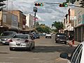
Downtown Eagle Pass
-
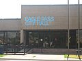
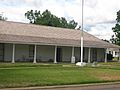
Eagle Pass City Hall at the foot of International Bridge
-
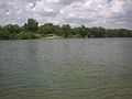
The Rio Grande at Eagle Pass, Texas, with Piedras Negras in the background
-
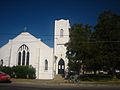
Historic First United Methodist Church on Quarry Street
-
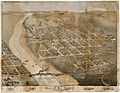
Map of the city 1887
-
The restored Fort Duncan in Eagle Pass is located near the International Bridge.
-
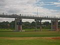
The International Bridge across the Rio Grande in Eagle Pass
-
The Eagle Pass public library is located on Main Street east of the Maverick County Courthouse.
-
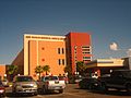
Fort Duncan Medical Center in Eagle Pass is named after the former US Army outpost.
-
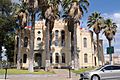
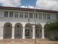
Historic Maverick County Courthouse
-
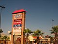
Mall de las Aguilas on Bibb Street in Eagle Pass


See also
 In Spanish: Eagle Pass (Texas) para niños
