
Eaglescliffe facts for kids
Quick facts for kids Eaglescliffe |
|
|---|---|
| Village | |
 Station Road |
|

Eaglescliffe
|
|
| Population | 10,449 (2011.ward) |
| OS grid reference | NZ421139 |
| Civil parish |
|
| Unitary authority |
|
| Ceremonial county | |
| Region | |
| Country | England |
| Sovereign state | United Kingdom |
| Post town | STOCKTON-ON-TEES |
| Postcode district | TS16 |
| Dialling code | 01642 |
| Police | Cleveland |
| Fire | Cleveland |
| Ambulance | North East |
| EU Parliament | North East England |
| UK Parliament |
|
Eaglescliffe is a village in the Borough of Stockton-on-Tees, County Durham, England. It is in the civil parish of Egglescliffe.
The village was formed around Eaglescliffe station and was formerly known as Eaglescliffe Junction. In 2011, the Office for National Statistics included the town, and areas from the Egglescliffe and Preston-on-Tees parishes in the Yarm built-up area.
Contents
History
The name of the town is thought to be derived from a misspelling of the name of the nearby village of Egglescliffe meaning a church on a hill. A common myth on the name change is that in the Victorian times the sign for the new railway station turned up incorrect after the signwriter thought that Egglescliffe was a mistake and altered it.
Bishop Skirlaw of Durham built a stone bridge across the Tees in 1400 which still stands. An iron replacement was built in 1805, but it fell down in 1806.
The Stockton and Darlington Railway passed through the grounds of Preston Hall in Eaglescliffe, and on the opening day there was a famous race between a stagecoach travelling down Yarm Road, and the Locomotion No. 1.
In 2011, Eaglescliffe was named the 4th best place for families to live in England and Wales, according to the savings firm Family Investments.
Allens West
From the 1940s to the 1990s there was an MOD base situated at Allens West in Eaglescliffe. After World War II the base was Metal Reclamation Unit No 2, and was used to dismantle aircraft that were downed in the north of England.
It then became the Royal Navy Spare Parts Distribution Centre (RNSPDC), and later the Royal Navy Supply Depot (RNSD) Eaglescliffe, until its closure in January 1997 as part of the 'Defence Cost Study'. The storage and distribution functions were transferred to Portsmouth Naval Base, and the procurement function to MOD's site at Abbey Wood, Bristol.
At its height, the Depot employed more than 2,000 staff and had a significant influence on the local economy. This later reduced to around 750 just prior to closure in 1997.
Part of the former MOD site is now the Urlay Nook Admiralty ecology park, the rest of the site was sold to a Distribution company in 1997.
Aerial photographs show that the site used to have railway sidings and a small runway.
A masterplan has been drawn up to build up to 1000 homes, a 5000m2 care home, 500m2 of community facilities, and up to 1000m2 of retail space on the site.
Geography
Eaglescliffe adjoins a small village called Egglescliffe, and legend says that the name Eaglescliffe came about when a mistake was made on the railway station's sign. The village lies in the civil parish of Egglescliffe, as does Urlay Nook, to the west. The north part of Eaglescliffe, to the west of the A135, lies within the parish of Preston-on-Tees. Several housing estates combine to form Eaglescliffe including Millfield, Kingsmead, Sunningdale, Hunters Green and Orchard Estate.
The main road through the town is the A135 Yarm Road which was part of the old route of the A19 until the 1970s when it was diverted near Thornaby-on-Tees to the east. Nearby towns include Stockton-On-Tees and Middlesbrough to the north and north-east and Darlington to the west.
Location

- Grid reference: NZ421139
- Latitude and longitude: 54°31′N 1°21′W / 54.517°N 1.350°W (54.51, −1.35)
- Road access: A67 from North and South, A66 from East and West.
- Rail access: Eaglescliffe Station, Allens West
- Nearest airport: Durham Tees Valley Airport
Events
Many events are held in Eaglescliffe every year, mostly in Preston Park which is situated to the north of the town on the Tees. Many of these events are run by Stockton Council.
Many local groups gather at the community centres and village halls within Eaglescliffe and its neighbouring village, Egglescliffe. Egglescliffe Community Centre is the largest, and plays host to two amateur dramatics groups – Cliffe Theatre (who produce at least two plays every year), and Centre Stage (who produce a pantomime every January, as well as a musical every summer). Egglescliffe Community Centre also hosts many other community groups including a Ladies Section, a weight loss group, dance classes, a weekly church service, and many others.
Sport and leisure

To the village's east is Eaglescliffe Golf Club – a course which occupies the land bordered to the south by the Sunningdale Estate, to the north by Teesside High School, and to the east by the River Tees. Many street names in the Sunningdale Estate, as well as the name of the local 'Links Primary School', reflect the location of this golf club. Preston Park has large playing fields.
Economy
Tetley Tea have had their only tea bag factory in the western world here since 1969 on Sowerby Way. It is the largest tea bag factory in the world, on the Durham Lane Industrial Park, having a floor area of 220,000 square feet (20,000 m2) and makes 18 billion tea bags a year; David Cameron and Boris Johnson have both visited the site. Warburtons have a bakery outside of the village to the north-east on the Preston Farm Industrial Estate. The Elementis Chromium site in nearby Urlay Nook closed in June 2009.
Education
Eaglescliffe has one secondary school called Egglescliffe School. This is in the east of the village and also has Egglescliffe Sixth Form College for ages 16–18. There are also four primary schools: Junction Farm, Durham Lane, The Links, and Preston. Egglescliffe village has a primary school called Egglescliffe CofE Primary School. As well as these there is also Teesside High School, an independent preparatory and high school, originally an all-girls school, it is now introducing boys within the framework of a diamond model of education.
Transport

Eaglescliffe railway station is staffed. Grand Central operate five trains a day direct to/from London Kings Cross station. Northern provide local services to Darlington, Middlesbrough, Saltburn, Sunderland and York. Allens West station also serves the village. The closest airport is Teesside International Airport.
Notable residents
- Matthew Bates, defender for Hartlepool FC, raised and schooled in the area
- Baroness Grey-Thompson DBE, paralympic athlete lives in Eaglescliffe
- Gary Havelock, speedway rider place of birth
- Frank Middlemass, actor
- Sir Samuel Alexander Sadler (1842–1911), industrialist, mayor and MP for Middlesbrough resided in Eaglescliffe
- James Wharton, Former MP for Stockton South
Images for kids
-
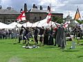
One of the events at Preston Park
-
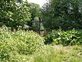
A popular walk is between Eaglescliffe Golf Course and Yarm


