
Earlwood, New South Wales facts for kids
Quick facts for kids EarlwoodSydney, New South Wales |
|||||||||||||||
|---|---|---|---|---|---|---|---|---|---|---|---|---|---|---|---|

Earlwood Hotel, Homer Street
|
|||||||||||||||
| Population | 17,741 (2016 census) | ||||||||||||||
| Established | 1829 | ||||||||||||||
| Postcode(s) | 2206 | ||||||||||||||
| Location | 10 km (6 mi) Inner West of Sydney CBD | ||||||||||||||
| LGA(s) | City of Canterbury-Bankstown | ||||||||||||||
| State electorate(s) | Canterbury | ||||||||||||||
| Federal Division(s) | Barton | ||||||||||||||
|
|||||||||||||||
Earlwood is a suburb in South Western Sydney, in the state of New South Wales, Australia. Earlwood is located 10 kilometres south-west of the Sydney central business district, in the local government area of the City of Canterbury-Bankstown.
Earlwood stretches from the southern bank of the Cooks River to the northern bank of Wolli Creek. Wolli Creek (the suburb), Turrella and Bardwell Park lie to the south across Wolli Creek, while Canterbury, Hurlstone Park and Marrickville are located to the north and east across Cooks River. The locality of Undercliffe is part of the suburb. Clemton Park adjoins the suburb to the west. Earlwood is primarily residential with some commercial developments around the main road, Homer Street.
Contents
History
Earlwood began as a land grant obtained by John Parkes in 1827. John Parkes and his sons operated logging camp called Parkes Camp in 1829 and felled the timber on his 50-acre grant. Later it became known as Parkestown. The name was changed to Forest Hill around 1905-06 and changed again to Earlwood in 1918. 'Earl' reportedly commemorated a former mayor of Canterbury and 'Wood' was the name of two brothers who owned a pig and poultry farm on Wolli Creek. The 'Earlwood' estate was a subdivision in the area of Earlwood Primary or Public School.
Early residents included F. and A. Martin who were granted land in the eastern part, and Joshua Thorpe, architect and Assistant Colonial Engineer, whose 80-acre (32 ha) estate was in the west, stretching from Cooks River to Wolli Creek. In 1828, Joshua Thorp built a house he called Juhan Munna, an Aboriginal phrase meaning "to go away." The house was later renamed Undecliffe and rented to managers of the Canterbury Sugarworks. The property was bought by the solicitor P.A.Tompson in 1850. In 1854, Tompson built a bridge on the site of Thorp's punt.
Frederick Wright Unwin, solicitor and director of the Australasian Sugar Company, obtained land in the Undercliffe area, east of Thorp's property, in 1840, and built his home, which he called Wanstead. Initially, a punt was used to cross the Cooks River. Later, a wooden bridge was built and the road eventually became known as Unwins Bridge Road. The name of the property survives in Wanstead Avenue and Wanstead Reserve. Abraham B. Pollack acquired eight grants in the 1830s, totalling 790 acres (320 ha), which covered most of Earlwood and Undercliffe. Subdivision began in the 1880s.
After World War I, a war services subdivision was created west of Wardell Road for retired soldiers and their families. The streets of that subdivision commemorate the names of famous men and battles connected with the war, such as Kitchener, Hamilton, Vimy, Fricourt, Polygon, Thompson and Guedecourt. The area incorporating Bedford, River, Grove, Richmond, and Stone streets was a subdivision known as the Canterbury estate and was divided for workers of the quarry at the end of River Street. This estate also took in Louisa, Sparke, Caroline, Elsie and Ann streets and also Willow lane, some of the streets had different names to those that they are known by today. A notable occupant of the area was the Scott family which operated the Scotties tissue factory on the corner of Louisa and River Streets.
Between 1912 and 1957, electric trams operated along Homer Street to Earlwood, providing service to the city via Marrickville and Newtown. The service is now provided by buses.
Transport
Earlwood is serviced by a number of bus routes by Transit Systems and Punchbowl Bus Company.
Earlwood was previously the end of the line for electric tram services running on a similar route to that of the current 423 bus service, an extension from the bottom of the hill at Undercliffe.
There are no railway stations in Earlwood itself, but the stations Bexley North, Bardwell Park and Turrella on the East Hills railway line are adjacent to its southern border, across Wolli Creek. Tempe station, on the Illawarra railway line, is adjacent to the east, across the Cooks River. The interchange station Wolli Creek is also physically close, but is not easily accessible from Earlwood because no crossing is nearby on Wolli Creek.
Parks and gardens
- Gough Whitlam Park and Waterworth reserve are on Bayview Avenue near Tempe station. Canterbury bicycle velodrome is located nearby. Clean up Australia day was originated here on the banks of Cooks river. The Cooks river Festival is an annual event held in Gough Whitlam park.
- Heynes Reserve is a passive recreation area at the junction of the Cooks River and Cup and Saucer Creek.
- Sutton Reserve is adjacent to Heynes Reserve. It features a playground and is connected to the northern bank of the Cooks River by a wooden footbridge.
- Hughes Park is a sporting and multi-use area located near the Canterbury border and runs along a concrete canal leading to the Cooks River.
- Simpson Reserve is further west along the Cooks River.
- Beaman Park and Wills Ground are located further east along the river near Wardell Road, and offer sporting fields, bike paths and BBQ facilities. Beaman Park is also home to Earlwood Wanderers soccer club. Stafford Walk, passing through the park alongside the river, was named after Ailsie Stafford, a long-time member of the Cooks River Valley Association. A plaque was installed on 6 May 1980.
- Earlwood Oval is a local park and sporting ground. It also has historical and social importance as a long-standing home to one of the lawn bowls clubs, cricket club, soccer and football fixtures and the location of one of very few "rocket" type playground fixtures. Important items include the early Earlwood oval gates and the memorial at the South Eastern end. Earlwood Oval also serves as the primary home ground for the football (soccer) club, Earlwood Wanderers.
- Girrawheen Park is a large recreational area along the northern bank of Wolli Creek. It provides spectacular views of Arncliffe, Turrella and Bardwell Park. This area is heritage listed and covers a large area of rare remnant bushland along the banks of Wolli creek and played a large part in the reasoning behind the construction of a road tunnel beneath the Bardwell valley.
- Wanstead Reserve, located between Wanstead Avenue and the Cooks River, was named after Wanstead, the property of Frederick Wright Unwin, established in 1840.
- In the 1960s, Nanny Goat Hill (sometimes known as Prickly Pear Hill) was about to be quarried for use as fill in the construction of Sydney Airport runway extensions. Harold May, Peter Ridsdale and Carl Lyons formed a resistance committee to thwart the operation and succeeded in having Canterbury Council cancel the proposed destruction of this now valued recreation area. The Canterbury Mayor Jim Beaman was an advisor to the May, Ridsdale, Lyons committee. Beaman Park is named after him.
Population
Demographics
Earlwood is a multicultural area, having a large proportion of Greek-Australians. Nearby Marrickville was a major centre of Sydney's Greek community in the 1950s and 1960s and many of its residents moved south into suburbs like Earlwood, which offered larger family homes and blocks of land. 20.4% of the population reported Greek ancestry at the 2011 Census.
According to the 2011 census of Population, there were 16,753 residents in Earlwood. 41.2% stated they were born overseas with the top countries of birth being Greece 8.7%, Italy 3.2%, China 2.9%, Portugal 2.6% and Lebanon 2.6%. English was stated as the only language spoken at home by 43.3% of residents and the most common other languages spoken were Greek 22.0%, Arabic 6.8% and Italian 4.9%. The most common responses for religious affiliation were Catholic 33.4%, Orthodox 27.6% and No Religion 13.3%.
Notable residents
The following notable people have lived in Earlwood:
- Former Prime Minister John Howard
- Actor Grahame Bond (The Aunty Jack Show)
- Actor Alex Dimitriades
- Boxers Anthony Mundine and Tony Mundine
- Former Newtown and Australian Rugby League player Dick Poole
Topography
Earlwood is sometimes mistakenly classed as a part of Sydney's Inner West. This is, however, topographically incorrect as the Cooks River which separates Earlwood from Marrickville forms a natural defining boundary around the outer limits of the Inner Western Suburbs.
- (Canterbury City Council.)
Images for kids
-
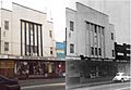
Earlwood Wines (left, 2000s) and Chelsea Theatre (right, 1950s)
-
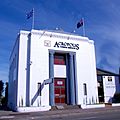
Acropolis Funeral services in former bank building in Homer Street
-
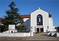
Our Lady of Lourdes Catholic Church
-
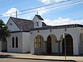
The Transfiguration of Our Lord Greek Orthodox Church
-
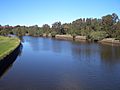
Cooks River, between Marrickville and Earlwood
-
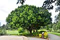
Tree at Gough Whitlam Park, Earlwood 2018
-
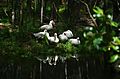
White ducks sunbathing at Gough Whitlam Park, Earlwood 2018
-
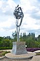
Statue of respect, unity & peace at Gought Whitlam Park 2018
-
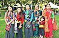
Women in traditional dress at Ubhauli Kirati festival 2017 at Gough Whitlam Park, Earlwood


