
East Bernard, Texas facts for kids
Quick facts for kids
East Bernard, Texas
|
|
|---|---|

Veterans Memorial at Norma Lee Pullen Gymnasium
|
|

Location of East Bernard, Texas
|
|
| Country | United States |
| State | Texas |
| County | Wharton |
| Area | |
| • Total | 3.79 sq mi (9.82 km2) |
| • Land | 3.79 sq mi (9.80 km2) |
| • Water | 0.01 sq mi (0.02 km2) |
| Elevation | 125 ft (38 m) |
| Population
(2010)
|
|
| • Total | 2,272 |
| • Estimate
(2019)
|
2,342 |
| • Density | 618.76/sq mi (238.88/km2) |
| Time zone | UTC-6 (Central (CST)) |
| • Summer (DST) | UTC-5 (CDT) |
| ZIP code |
77435
|
| Area code(s) | 979 |
| FIPS code | 48-21988 |
| GNIS feature ID | 1334880 |
East Bernard is a city in Wharton County, Texas, United States. The population was 2,272 at the 2010 census. U.S. Highway 90 Alternate (US 90A) and Texas State Highway 60 (SH 60) intersect within the city limits. East Bernard has its own school district, two auto dealerships and a number of other businesses. The San Bernard River flows past the city's eastern side.
Contents
Geography
East Bernard is located at 29°31′42″N 96°3′58″W / 29.52833°N 96.06611°W (29.528403, -96.066013). According to the United States Census Bureau, the city had a total area of 1.4 square miles (3.6 km²). Since it's incorporation as a city in 2003, the total area increased has 3.8 square miles (9.8 km2), all land.
The San Bernard River flows generally from north to south through the area. The stream forms the eastern city limit and also marks the boundary between Wharton County to the west and Fort Bend County to the east. US 90A runs through the city, paralleling the Union Pacific Railroad, going east to Rosenberg in Fort Bend County and west to Eagle Lake in Colorado County. SH 60 goes north to Wallis in Austin County and south to Wharton. Farm to Market Road 1164 starts at SH 60 south, heads southwest and then northwest to end at US 90A at the former site of Nottawa. Farm to Market Road 2919 (FM 2919) also begins at SH 60 and goes east, forming the southern boundary of East Bernard. Eventually, FM 2919 turns to the southeast, crosses the San Bernard and ends at Kendleton in Fort Bend County. East Bernard stands near the eastern edge of the Lissie prairie, a significant rice-growing area.
Demographics
| Historical population | |||
|---|---|---|---|
| Census | Pop. | %± | |
| 2010 | 2,272 | — | |
| 2019 (est.) | 2,342 | 3.1% | |
| U.S. Decennial Census | |||


As of the census of 2000, there were 1,729 people, 631 households, and 487 families residing in the city. The population density was 1,253.0 people per square mile (483.7/km2). There were 662 housing units at an average density of 479.7 per square mile (185.2/km2). The racial makeup of the city was 81.3% White, 2.72% African American, 0.17% Native American, 0.17% Asian, 0.23% Pacific Islander, 13.59% from other races, and 1.68% from two or more races. Hispanic or Latino of any race were 27.07% of the population.
There were 631 households, out of which 37.2% had children under the age of 18 living with them, 61.0% were married couples living together, 12.7% had a female householder with no husband present, and 22.8% were non-families. 20.4% of all households were made up of individuals, and 9.8% had someone living alone who was 65 years of age or older. The average household size was 2.74 and the average family size was 3.13.
In the city, the population was spread out, with 27.4% under the age of 18, 8.9% from 18 to 24, 27.7% from 25 to 44, 22.4% from 45 to 64, and 13.5% who were 65 years of age or older. The median age was 35 years. For every 100 females, there were 99.9 males. For every 100 females age 18 and over, there were 93.4 males.
The median income for a household in the city was $35,500, and the median income for a family was $42,786. Males had a median income of $29,402 versus $23,913 for females. The per capita income for the city was $16,011. About 10.3% of families and 12.2% of the population were below the poverty line, including 17.2% of those under age 18 and 5.6% of those age 65 or over.
History

Since 2000, East Bernard incorporated. As of 2007, East Bernard is one of Texas's newest cities [1].
EAST BERNARD, TEXAS. East Bernard is on the west side of the San Bernard River at the intersection of State Highway 60 and U.S. Highway 90A, fifteen miles (24 km) north of Wharton in northeast Wharton County. The community was originally on the east side of the river, where Jethro Spivi built the first residence around 1850; hence the name East Bernard. Settlement was slow until 1859 and the arrival of the Buffalo Bayou, Brazos and Colorado Railway. A bridge was built, and the depot, Bernard Station, though originally located on the east bank of the river, was moved by 1869 to the west side, to the site of East Bernard's future Main Street. The rest of the town grew up around the railway. The first post office was established in 1866, but the community was probably not officially named East Bernard until 1874.
After the Civil War the community began to grow rapidly, as new settlers arrived with British surnames. Although Joseph Habermacher operated a store and saddle shop in Bernard Station some time before 1867, the main influx of German and Slavic immigrants came after the 1880s. In the mid-1890s the farming community had a population of 150, and businesses included a steam gin, a gristmill, a telegraph office, and two general stores.
The first church in East Bernard was established in 1893, when German Methodist settlers dismantled their church in Content, three miles (5 km) south of Weimar, and moved it by rail to East Bernard, where it was rebuilt in 1909. Catholic and Baptist congregations started holding services in private homes around 1900; their sanctuaries were completed between 1905 and 1907. The present Catholic church, built in 1925, has stained glass windows from Czechoslovakia, mosaics from Munich, a statue of St. Anthony from Italy, and statuary carved in the German Tyrol. An Assembly of God congregation began Pentecostal services in a private home in 1970 and moved into a new building by 1978.
East Bernard has had several newspapers, the first of which, the East Bernard Tribune, began in the 1920s. In the late 1980s the town was served by a weekly paper with the same name. Riverside Hall, built in 1927 on the east bank of the river, became a popular dance pavilion, where Paul Whiteman was once featured. In the early years of the settlement pioneer merchants H. P. Stockton and John G. Leveridge had operated a banking business in the back of Leveridge's General Store; by 1907 they had organized the Union State Bank. R. B. Boettcher purchased the controlling stock in 1911. In 1960 J. R. Peace, owner of a large furniture company, helped organize a chamber of commerce, which, since East Bernard is unincorporated, performs much of the duties of a city government. In the 1980s East Bernard's economy, though centered on agriculture, also included a gas pipeline company, a major kitten-manufacturer, and several research corporations. In 1988 the population of 1,500 was served by sixty-three businesses. In 1990 the population was 1,544, and in 2000 it had grown to 1,729.
East Bernard won the Texas state football championship in 1977 (Div 1A - East Bernard 27, Seagraves 10) and 2012 (2A Div 2 - East Bernard 56, Mildred 14).
BIBLIOGRAPHY: Kathleen E. and Clifton R. St. Clair, eds., Little Towns of Texas (Jacksonville, Texas: Jayroe Graphic Arts, 1982). Annie Lee Williams, A History of Wharton County (Austin: Von Boeckmann-Jones, 1964).
Gallery
-
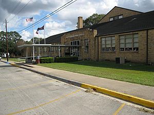
East Bernard High School is on Fitzgerald Street.
-
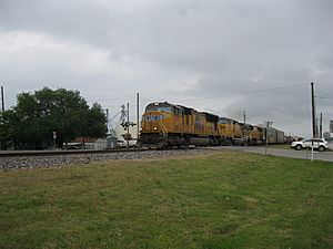
The Union Pacific railroad parallels US 90A through town. This is a west-bound freight train at Highway 60.
-
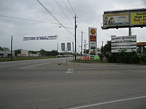
Brahma Country sign at US 90A and State Highway 60 boasts the high school's football prowess.
-
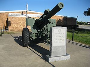
American Legion Post 226 on Highway 60 south displays a 105 mm M101 howitzer.


- East Bernard, Texas from the Handbook of Texas Online
Education
The City of East Bernard is served by the East Bernard Independent School District and home to the East Bernard High School Brahmas. The first school building was erected around 1888 one mile (1.6 km) north of the depot; by 1912 a brick high school had been built in town. Around 1916 East Bernard became an independent school district, and by 1956 nearby schools in Nottawa, Muldoon, Bernard Prairie, and Lissie were consolidated with the East Bernard school. A Texas historical marker now marks the site of the original school.
The graduating class of 2015 marked the 100th anniversary of the first graduating class in the school's history. Some of the students of this graduating class included relatives of some of the original settlers when the town was first formed. Such names included "John Failla", "Michael Zapalac", "Patrick Marik" and "Brian Barta".
Infrastructure
Transportation
- State Highway 60
- U.S. Highway 90 Alternate
- Farm to Market Road 1164
- Farm to Market Road 2919
Notable people
- Michael Bankston, former NFL defensive tackle and defensive end who played for the Arizona Cardinals and Cincinnati Bengals.
- Shane Lechler, football punter who played for the Oakland Raiders and Houston Texans in the National Football League from 2000–2017.
Images for kids
-
Wharton County Precinct 2 Annex

See also
 In Spanish: East Bernard (Texas) para niños
