
East Honolulu, Hawaii facts for kids
Quick facts for kids
East Honolulu
|
|
|---|---|
 |
|
| Country | |
| State | |
| Counties | |
| Area | |
| • Total | 34.45 sq mi (89.24 km2) |
| • Land | 23.01 sq mi (59.58 km2) |
| • Water | 11.45 sq mi (29.65 km2) |
| Population
(2020)
|
|
| • Total | 50,922 |
| • Density | 2,213.42/sq mi (854.61/km2) |
| Time zone | UTC-10 |
| Area code(s) | 808 |
| GNIS feature ID | 2583416 |
East Honolulu is a census-designated place (CDP) located in Honolulu County, Hawaii, United States. As of the 2020 Census, the CDP had a population of 50,922, making it the 2nd most populated CDP in Hawaii, behind Honolulu.
Geography
East Honolulu is centered on 21°17′20″N 157°43′2″W / 21.28889°N 157.71722°W (21.2891, -157.7173). According to the United States Census Bureau, the CDP has a total area of 3.4 square miles (8.9 km2), of which 2.3 square miles (6.0 km2) is land and 1.2 square miles (3.0 km2), or 33.22%, is water.
East Honolulu consists of the area directly east of the center of Honolulu, beginning at the Wai'alae Country Club and extending east to Makapu'u Point, the easternmost point on the island of Oahu. It consists of mostly upscale neighborhoods.
Demographics
| Historical population | |||
|---|---|---|---|
| Census | Pop. | %± | |
| 2020 | 50,922 | — | |
|
|
|||
Education
Hawaii Department of Education operates area public schools.
Elementary schools:
- Ana Haina Elementary School
- Haha'ione Elementary School
- Kamilo'iki Elementary School
- Koko Head Elementary School
Middle schools:
- Niu Valley Middle School
High schools:
- Henry J. Kaiser High School
- Kalani High School
Private schools:
- The Roman Catholic Diocese of Honolulu maintains the Holy Nativity School
- Honolulu Waldorf School
Hawaii State Public Library System maintains the Aina Haina Public Library.
Images for kids
-
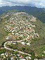
Puuikena Drive in East Honolulu

See also
 In Spanish: East Honolulu para niños
