
East Side, Providence, Rhode Island facts for kids

The East Side is a collection of neighborhoods in the eastern part of the city of Providence, Rhode Island. It officially comprises the neighborhoods of Blackstone, Hope (commonly known as Summit), Mount Hope, College Hill, Wayland, and Fox Point.

The area is separated from East Providence, Rhode Island, to the east by the Seekonk River. To the west it is separated from the rest of Providence by the Providence River and Interstate 95. To the north, it borders Pawtucket, Rhode Island. To the south, it abuts Narragansett Bay, which is formed by the confluence of the Seekonk and Providence Rivers.
Roger Williams founded Providence along College Hill. This area thus includes some of the oldest sections of the city. The spot where Williams landed after crossing the Seekonk River is marked by a small park in Fox Point.
Contents
Parks
The East Side contains numerous parks and green spaces. India Point Park, the largest of these, is located along the northernmost shore of Narragansett Bay. It is the only large expanse of Bay-side shoreline in Providence reserved for public use.
Interstate 195 separates the park from the rest of Fox Point. Construction plans for the relocation of 195 include plans for a new, larger pedestrian bridge over the interstate, to allow better access between the park and the rest of India Point.
Other parks include:
- Blackstone Boulevard Park is a green space between northbound and southbound lanes of Blackstone Boulevard. It consists of 19.3 acres (7.8 ha) of parkland and a 1.7-mile (2.7 km) path for jogging and walking.
- Blackstone Park just north of Richmond Square at the end of Waterman Street in Wayland. Blackstone Park is 40-acre (16 ha) city park with 2,400 feet (730 m) of shore frontage on the Seekonk River.
- Constance Witherby Park in Wayland.
- Gano Street Park, along the Seekonk River, has numerous athletic fields and a dog-park. The area is also known as Engineer's Field.
- Lippitt Memorial Park, a 6-acre (2.4 ha) park at the intersection of Hope Street and Blackstone Boulevard near the Pawtucket border. It is named after former Rhode Island governor Charles W. Lippitt.
- Market Square, a small park on the edge of Downtown.
- Mary Sharpe Park, a small park between Benefit and Pratt Avenue.
- Paterson Park, a small park in Wayland adjacent to Blackstone Park.
- Gladys Potter Park is a small park in Wayland at the corner of Elton St. and Humboldt Ave.
- Prospect Terrace Park on top of College Hill.
- Roger William's Landing in Fox Point.
- Roger Williams National Memorial at the bottom of College Hill.
- Riverwalk located along the Providence River, where part of Waterfire is held.
- Veterans' Memorial Park, on the edge of Downtown, is home to a war memorial.
Demographics
Mostly residential, the East Side is the most affluent part of the city with higher property values, lower unemployment, and higher income levels than the city as a whole. Approximately 20% of the city's 190,934 people live on the East Side. Mount Hope and the area along Elmgrove Avenue have historically had a large community of Russian Jews.
Landmarks

The East Side contains the oldest section of the city. The Providence Preservation Society and the Rhode Island Historical Society have preserved numerous historic buildings, especially in the College Hill area. Historic landmarks include:
- The Athenaeum: The fourth oldest library in America, located on Benefit Street.
- The Central Congregational Church, An 1893 Carrère and Hastings-designed church on Angell Street.
- The First Baptist Church in America: The oldest Baptist church in the United States, founded by Roger Williams in 1638. It is located on North Main Street.
- The First Christian Science Church: A domed church on Meeting Street.
- The John Brown House: The home of John Brown (1736–1803), a china trader, slave trader, and Federalist, his family financed the establishment of Brown University. His house is located at the corner of Benefit and Power Street.
- The Marine Armory: An armory in service during the American Civil War, it was the first headquarters of the Rhode Island State Police.
- The Old State House: The former statehouse of Rhode Island.
- H.P. Lovecraft Memorial Square
Images for kids
-
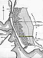
Original 1650 settlement plots on the East Side.
-
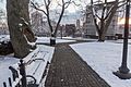
Prospect Terrace Park, College Hill
-

India Point Park, Fox Point
-
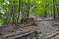
Blackstone Park
-
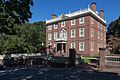
John Brown House (1786) is one of many 18th and 19th century structures on the East Side.


.jpg)


