
East Tennessee facts for kids
Quick facts for kids
East Tennessee
|
|
|---|---|
|
Grand Division
|
|
       Images, from top down, left to right: Clingmans Dome in Great Smoky Mountains National Park, Neyland Stadium at the University of Tennessee, skyline of Knoxville, skyline of Chattanooga, Norris Dam and its reservoir, Oak Ridge National Laboratory, Sycamore Shoals State Historic Area
|
|
| Nickname(s):
East TN, East Tenn.
|
|

The counties of Tennessee highlighted in red that are designated part of East Tennessee.
|
|
| Country | |
| State | |
| Largest city | Knoxville |
| Area | |
| • Land | 35,115.8 km2 (13,558.27 sq mi) |
| Population
(2020)
|
2,470,105 |
| • Density | 70.34/km2 (182.18/sq mi) |
| Demonym(s) | East Tennessean |
East Tennessee is one of the three Grand Divisions of Tennessee defined in state law. Geographically and socioculturally distinct, it comprises approximately the eastern third of the U.S. state of Tennessee. East Tennessee consists of 33 counties, 30 located within the Eastern Time Zone and three counties in the Central Time Zone, namely Bledsoe, Cumberland, and Marion. East Tennessee is entirely located within the Appalachian Mountains, although the landforms range from densely forested 6,000-foot (1,800 m) mountains to broad river valleys. The region contains the major cities of Knoxville and Chattanooga, Tennessee's third and fourth largest cities, respectively, and the Tri-Cities, the state's sixth largest population center.
During the American Civil War, many East Tennesseans remained loyal to the Union even as the state seceded and joined the Confederacy. Early in the war, Unionist delegates unsuccessfully attempted to split East Tennessee into a separate state that would remain as part of the Union. After the war, a number of industrial operations were established in cities in the region. The Tennessee Valley Authority (TVA), created by Congress during the Great Depression in the 1930s, spurred economic development and helped to modernize the region's economy and society. The TVA would become the nation's largest public utility provider. Today, the TVA's administrative operations are headquartered in Knoxville and its power operations are based in Chattanooga. Oak Ridge was the site of the world's first successful uranium enrichment operations, which were used to construct the world's first atomic bombs, two of which were dropped on Imperial Japan at the end of World War II. The Appalachian Regional Commission further transformed the region in the late 20th century.
East Tennessee is both geographically and culturally part of Appalachia, and has been included— along with Western North Carolina, North Georgia, Eastern Kentucky, Southwest Virginia, the state of West Virginia, western Maryland, and southwestern Pennsylvania — in every major definition of the Appalachian region since the early 20th century. East Tennessee is home to the nation's most visited national park— the Great Smoky Mountains National Park— and hundreds of smaller recreational areas. East Tennessee is often considered the birthplace of country music, due largely to the 1927 Victor recording sessions in Bristol, and throughout the 20th and 21st centuries has produced a steady stream of musicians of national and international fame.
Contents
Geography

Unlike the geographic designations of regions of most U.S. states, the term East Tennessee has legal as well as socioeconomic meaning. East Tennessee, along with Middle Tennessee and West Tennessee, comprises one of the state's three Grand Divisions. According to the Tennessee State Constitution, no more than two of the Tennessee Supreme Court's five justices can come from any one Grand Division. The Supreme Court rotates meeting in courthouses in each of the three divisions. The Supreme Court building for East Tennessee is in Knoxville. A similar rule applies to certain other commissions and boards as well, to prevent them from showing a geographic bias.
Topography
East Tennessee includes parts of three major geological divisions— the Blue Ridge on the border with North Carolina in the east, the Ridge-and-Valley Appalachians (usually called the "Great Appalachian Valley" or "Tennessee Valley") in the center, and the Cumberland Plateau in the west, bordering Middle Tennessee.
The Blue Ridge section comprises the western (or "Unaka") section of the Blue Ridge Province, the crest of which forms most of the Tennessee-North Carolina border and consists of the highest parts of the state (including Clingmans Dome, the state's highest point). The Blue Ridge is subdivided into several subranges— the Iron Mountains, Roan Highlands, and Bald Mountains in the north, the Great Smoky Mountains in the center, and the Unicoi Mountains and Little Frog and Big Frog Mountain areas in the south. Most of the Blue Ridge section is heavily forested and protected by various state and federal entities, the largest of which include the Great Smoky Mountains National Park and the Cherokee National Forest.

The Ridge-and-Valley section, often called the Tennessee Valley or "Great Valley," is the region's largest and most populous section. It consists of a series of alternating elongate ridges and broad river valleys roughly oriented northeast-to-southwest. This section's most notable feature, the Tennessee River, forms at the confluence of the Holston and French Broad rivers in Knoxville, and flows southwestward to Chattanooga, where it enters the Tennessee River Gorge. Other notable rivers in the upper Tennessee watershed include the Clinch, Nolichucky, Watauga, Emory, Little Tennessee, Hiwassee, Sequatchie, and Ocoee rivers. Notable "ridges" in the Ridge-and-Valley range include Clinch Mountain, Bays Mountain, and Powell Mountain.
The Cumberland Plateau rises nearly 1,000 feet (300 m) above the Tennessee Valley, stretching from Cumberland Gap at the Tennessee-Kentucky-Virginia border southwestward to the Alabama border. The "Tennessee Divide" runs along the western part of the plateau, and separates the watersheds of the Tennessee and Cumberland rivers. Plateau counties mostly east of this divide— i.e. Cumberland, Morgan, and Scott— are grouped with East Tennessee, whereas plateau counties west of this divide (Fentress, Van Buren, and Grundy) are considered part of Middle Tennessee. Three counties— Bledsoe, Sequatchie, and Marion— are located in the Sequatchie Valley, a long narrow valley in the southern part of the Cumberland Plateau. These three counties were traditionally part of East Tennessee. However, Sequatchie and Marion counties were reassigned to the Middle Tennessee grand division circa 1932. Marion County was later returned to East Tennessee, but Sequatchie County officially remains part of Middle Tennessee. One notable detached section of the Plateau is Lookout Mountain, which overlooks Chattanooga.
Counties
Cities

The major cities of East Tennessee are Knoxville (near the center of East Tennessee), Chattanooga (in southeastern Tennessee at the Georgia border), and the "Tri-Cities" of Bristol, Johnson City, and Kingsport located in the extreme northeasternmost part of the state. The Blue Ridge section of the state is much more sparsely populated, its main cities being Elizabethton, Gatlinburg, and Tellico Plains. Crossville and Jasper are prominent cities in the Plateau region.
- Cities and towns with 10,000+ population (2013 estimates)
- Knoxville (pop. 183,270)
- Chattanooga (pop. 173,366)
- Johnson City (pop. 65,123)
- Kingsport (pop. 52,962)
- Cleveland (pop. 42,774)
- Oak Ridge (pop. 27,387)
- Morristown (pop. 24,965)
- Bristol (pop. 24,821)
- Maryville (pop. 23,120)
- East Ridge (pop. 21,382)
- Farragut (pop. 17,720)
- Sevierville (pop. 16,011)
- Greeneville (pop. 15,020)
- Elizabethton (pop. 14,359)
- Athens (pop. 13,623)
- Red Bank (pop. 11,830)
- Soddy-Daisy (pop. 13,118)
Climate
| Climate data for Chattanooga Metropolitan Airport, Tennessee (1981–2010 normals, extremes 1879–present) | |||||||||||||
|---|---|---|---|---|---|---|---|---|---|---|---|---|---|
| Month | Jan | Feb | Mar | Apr | May | Jun | Jul | Aug | Sep | Oct | Nov | Dec | Year |
| Record high °F (°C) | 78 (26) |
79 (26) |
89 (32) |
93 (34) |
99 (37) |
107 (42) |
107 (42) |
105 (41) |
104 (40) |
94 (34) |
86 (30) |
78 (26) |
107 (42) |
| Mean maximum °F (°C) | 67.9 (19.9) |
72.5 (22.5) |
80.7 (27.1) |
86.4 (30.2) |
89.4 (31.9) |
94.9 (34.9) |
97.1 (36.2) |
96.4 (35.8) |
92.3 (33.5) |
84.7 (29.3) |
77.0 (25.0) |
68.0 (20.0) |
98.4 (36.9) |
| Average high °F (°C) | 50.2 (10.1) |
54.8 (12.7) |
63.7 (17.6) |
72.7 (22.6) |
79.9 (26.6) |
87.1 (30.6) |
90.2 (32.3) |
89.6 (32.0) |
83.2 (28.4) |
73.1 (22.8) |
62.3 (16.8) |
52.1 (11.2) |
71.6 (22.0) |
| Average low °F (°C) | 30.7 (−0.7) |
34.0 (1.1) |
40.7 (4.8) |
48.3 (9.1) |
57.3 (14.1) |
65.8 (18.8) |
69.7 (20.9) |
69.2 (20.7) |
61.8 (16.6) |
49.9 (9.9) |
40.2 (4.6) |
33.1 (0.6) |
50.1 (10.1) |
| Mean minimum °F (°C) | 13.1 (−10.5) |
17.5 (−8.1) |
24.7 (−4.1) |
32.6 (0.3) |
43.2 (6.2) |
55.1 (12.8) |
62.2 (16.8) |
60.8 (16.0) |
48.0 (8.9) |
34.1 (1.2) |
25.6 (−3.6) |
17.4 (−8.1) |
9.9 (−12.3) |
| Record low °F (°C) | −10 (−23) |
−10 (−23) |
2 (−17) |
25 (−4) |
34 (1) |
39 (4) |
51 (11) |
50 (10) |
36 (2) |
22 (−6) |
4 (−16) |
−2 (−19) |
−10 (−23) |
| Average precipitation inches (mm) | 4.91 (125) |
4.84 (123) |
4.98 (126) |
3.99 (101) |
4.10 (104) |
4.05 (103) |
4.91 (125) |
3.48 (88) |
4.04 (103) |
3.28 (83) |
5.00 (127) |
4.90 (124) |
52.48 (1,333) |
| Average snowfall inches (cm) | 1.7 (4.3) |
0.6 (1.5) |
1.2 (3.0) |
0.1 (0.25) |
0 (0) |
0 (0) |
0 (0) |
0 (0) |
0 (0) |
0 (0) |
trace | 0.3 (0.76) |
3.9 (9.9) |
| Average precipitation days (≥ 0.01 in) | 10.7 | 10.2 | 10.7 | 9.5 | 10.6 | 10.4 | 11.7 | 9.4 | 8.0 | 7.7 | 9.6 | 11.1 | 119.6 |
| Average snowy days (≥ 0.1 in) | 1.0 | 0.9 | 0.3 | 0 | 0 | 0 | 0 | 0 | 0 | 0 | 0.1 | 0.4 | 2.7 |
| Average relative humidity (%) | 71.2 | 68.2 | 65.9 | 63.8 | 71.5 | 73.1 | 74.9 | 76.0 | 77.0 | 74.6 | 73.5 | 72.9 | 71.9 |
| Mean monthly sunshine hours | 147.0 | 155.6 | 200.5 | 240.2 | 275.6 | 275.5 | 265.2 | 256.8 | 227.9 | 218.8 | 158.7 | 140.4 | 2,562.2 |
| Percent possible sunshine | 47 | 51 | 54 | 61 | 64 | 63 | 60 | 62 | 61 | 63 | 51 | 46 | 58 |
| Source: NOAA (relative humidity and sun 1961–1990) | |||||||||||||
| Climate data for Knoxville, Tennessee (McGhee Tyson Airport), 1981−2010 normals, extremes 1871–present | |||||||||||||
|---|---|---|---|---|---|---|---|---|---|---|---|---|---|
| Month | Jan | Feb | Mar | Apr | May | Jun | Jul | Aug | Sep | Oct | Nov | Dec | Year |
| Record high °F (°C) | 77 (25) |
83 (28) |
88 (31) |
93 (34) |
96 (36) |
105 (41) |
105 (41) |
102 (39) |
103 (39) |
94 (34) |
85 (29) |
80 (27) |
105 (41) |
| Average high °F (°C) | 47.3 (8.5) |
52.3 (11.3) |
61.4 (16.3) |
70.3 (21.3) |
78.1 (25.6) |
85.4 (29.7) |
88.2 (31.2) |
87.8 (31.0) |
81.8 (27.7) |
71.2 (21.8) |
60.4 (15.8) |
49.8 (9.9) |
69.5 (20.8) |
| Average low °F (°C) | 29.2 (−1.6) |
32.4 (0.2) |
39.2 (4.0) |
47.3 (8.5) |
56.2 (13.4) |
64.7 (18.2) |
68.7 (20.4) |
67.8 (19.9) |
60.4 (15.8) |
48.5 (9.2) |
39.0 (3.9) |
31.7 (−0.2) |
48.8 (9.3) |
| Record low °F (°C) | −24 (−31) |
−10 (−23) |
1 (−17) |
22 (−6) |
32 (0) |
42 (6) |
49 (9) |
49 (9) |
35 (2) |
24 (−4) |
5 (−15) |
−6 (−21) |
−24 (−31) |
| Average precipitation inches (mm) | 4.32 (110) |
4.26 (108) |
4.34 (110) |
4.01 (102) |
4.51 (115) |
3.81 (97) |
5.08 (129) |
3.27 (83) |
3.24 (82) |
2.51 (64) |
4.01 (102) |
4.50 (114) |
47.86 (1,216) |
| Average snowfall inches (cm) | 2.7 (6.9) |
1.6 (4.1) |
0.9 (2.3) |
0.5 (1.3) |
0 (0) |
0 (0) |
0 (0) |
0 (0) |
0 (0) |
0 (0) |
trace | 0.8 (2.0) |
6.5 (17) |
| Average precipitation days (≥ 0.01 in) | 11.2 | 11.0 | 12.0 | 10.7 | 11.4 | 11.4 | 11.3 | 8.8 | 7.7 | 8.2 | 9.9 | 11.6 | 125.2 |
| Average snowy days (≥ 0.1 in) | 1.5 | 1.2 | 0.6 | 0.1 | 0 | 0 | 0 | 0 | 0 | 0 | 0 | 0.8 | 4.2 |
| Average relative humidity (%) | 71.7 | 68.0 | 64.8 | 63.3 | 70.8 | 73.5 | 75.7 | 76.3 | 76.1 | 73.0 | 71.8 | 72.9 | 71.5 |
| Mean monthly sunshine hours | 135.8 | 145.3 | 208.9 | 256.6 | 287.2 | 291.1 | 287.3 | 278.0 | 232.3 | 217.2 | 151.7 | 122.5 | 2,613.9 |
| Percent possible sunshine | 44 | 48 | 56 | 65 | 66 | 67 | 65 | 67 | 62 | 62 | 49 | 40 | 59 |
| Source: NOAA (relative humidity and sun 1961–1990) | |||||||||||||
Population and demographics
| Historical population | |||
|---|---|---|---|
| Census | Pop. | %± | |
| 1790 | 25,030 | — | |
| 1800 | 73,419 | 193.3% | |
| 1810 | 101,367 | 38.1% | |
| 1820 | 138,023 | 36.2% | |
| 1830 | 196,357 | 42.3% | |
| 1840 | 224,259 | 14.2% | |
| 1850 | 260,397 | 16.1% | |
| 1860 | 301,001 | 15.6% | |
| 1870 | 332,547 | 10.5% | |
| 1880 | 428,704 | 28.9% | |
| 1890 | 543,091 | 26.7% | |
| 1900 | 640,222 | 17.9% | |
| 1910 | 732,471 | 14.4% | |
| 1920 | 814,648 | 11.2% | |
| 1930 | 960,133 | 17.9% | |
| 1940 | 1,101,099 | 14.7% | |
| 1950 | 1,288,886 | 17.1% | |
| 1960 | 1,377,281 | 6.9% | |
| 1970 | 1,486,765 | 7.9% | |
| 1980 | 1,768,149 | 18.9% | |
| 1990 | 1,832,138 | 3.6% | |
| 2000 | 2,108,133 | 15.1% | |
| 2010 | 2,327,544 | 10.4% | |
| 2020 | 2,470,105 | 6.1% | |
| Source: 1910–2020 | |||
East Tennessee is the second most populous and most densely populated of the three Grand Divisions. At the 2020 census it had 2,470,105 inhabitants living in its 33 counties, and increase of 142,561, or 6.12%, over the 2010 figure of 2,327,544 residents. Its population was 35.74% of the state's total, and its population density was 182.18 inhabitants per square mile (70.34/km2). Prior to the 2010 census, East Tennessee was the most populous of the state's Grand Divisions, but was surpassed by Middle Tennessee, which contains the rapidly-growing Nashville and Clarksville metropolitan areas.
Demographically, East Tennessee is one of the regions in the United States with one of the highest concentrations of people who identify as White or European American. In the 2010 census, every county in East Tennessee except for Knox and Hamilton, the two most populous counties, had a population that was greater than 90% White. In most counties in East Tennessee, persons of Hispanic or Latino origins outnumber African Americans, which is uncommon in the Southeastern United States. Large African American populations are found in Chattanooga and Knoxville, as well as considerable populations in several smaller cities.
Cities and metropolitan areas
The major cities of East Tennessee are Knoxville, which is near the geographic center of the region; Chattanooga, which is in southeastern Tennessee at the Georgia border; and the "Tri-Cities" of Bristol, Johnson City, and Kingsport, located in the extreme northeasternmost part of the state. Of the ten metropolitan statistical areas in Tennessee designated by the Office of Management and Budget (OMB), six are in East Tennessee. Also designated by the OMB in East Tennessee are the Knoxville-Sevierville-La Follette, Chattanooga-Cleveland-Athens and Tri-Cities combined statistical areas.
Knoxville, with about 190,000 residents, is the state's third largest city, and contains the state's third largest metropolitan area, with about 1 million residents. Chattanooga, with a population of more than 180,000, is the state's fourth largest city, and anchors a metropolitan area with more than 500,000 residents, of whom approximately one-third live in Georgia. The Tri-Cities, while defined by the Office of Management and Budget as the Kingsport-Bristol and Johnson City metropolitan areas, are usually considered one population center, which is the third-most populous in East Tennessee and the fifth-largest statewide.
Most of East Tennessee's population is found in the Ridge-and Valley region, including that of its major cities. Other important cities in the Ridge and Valley region include Cleveland, Athens, Maryville, Oak Ridge, Sevierville, Morristown, and Greeneville. The region also includes the Cleveland and Morristown metropolitan areas, each of which contain more than 100,000 residents. The Blue Ridge section of the state is much more sparsely populated, its main cities being Elizabethton, Pigeon Forge, and Gatlinburg. Crossville is the largest city in the Plateau region, which is also sparsely populated.
Most residents of the East Tennessee region commute by car with the lack of alternative modes of transportation such as commuter rail or regional bus systems. Residents of the metropolitan areas for Knoxville, Morristown, Chattanooga, and the Tri-Cities region have an estimated one-way commute of 23 minutes.
|
Largest cities or towns in East Tennessee
Source: |
||
|---|---|---|
| Rank | Pop. | |
| 1 | Knoxville | 190,740 |
| 2 | Chattanooga | 181,099 |
| 3 | Johnson City | 71,046 |
| 4 | Kingsport | 55,442 |
| 5 | Cleveland | 47,356 |
| 6 | Maryville | 31,907 |
| 7 | Oak Ridge | 31,402 |
| 8 | Morristown | 30,431 |
| 9 | Bristol | 27,147 |
| 10 | Farragut | 23,506 |
Congressional districts
East Tennessee includes all of the state's 1st, 2nd, and 3rd congressional districts, and part of the 4th district. The First District is concentrated around the Tri-Cities region and Upper East Tennessee. The Second District includes Knoxville and the mountain counties to the south. The Third District includes the Chattanooga area and the counties north of Knoxville (the two areas are connected by a narrow corridor in eastern Roane County). The Fourth, which extends into an area southwest of Nashville, includes several of East Tennessee's Cumberland Plateau counties.
History
American Indians
Much of what is known about East Tennessee's prehistoric American Indians comes as a result of TVA's reservoir construction, as federal law required archaeological investigations to be conducted in areas that were to be flooded. Excavations at the Icehouse Bottom site near Vonore revealed that American Indians were living in East Tennessee on at least a semi-annual basis as early as 7,500 B.C. The region's significant Woodland period (1000 B.C. – 1000 A.D.) sites include Rose Island (also near Vonore) and Moccasin Bend (near Chattanooga). During what archaeologists call the Mississippian period (c. 1000–1600 A.D.), East Tennessee's American Indian inhabitants were living in complex agrarian societies at places such as Toqua and Hiwassee Island, and had formed a minor chiefdom known as Chiaha in the French Broad Valley. Spanish expeditions led by Hernando de Soto, Tristan de Luna, and Juan Pardo all visited East Tennessee's Mississippian-period inhabitants during the 16th century.
By the time English explorers began arriving in what is now East Tennessee in the late 17th century, the Cherokee had become the region's dominant tribe. The Cherokee established a series of towns concentrated in the Little Tennessee and Hiwassee valleys that became known as the "Overhill towns", as traders from North Carolina, South Carolina, and Virginia had to cross "over" the mountains to reach them. The Cherokee alliance with Britain during the French and Indian War led to the construction of Fort Loudoun in 1756. A peace expedition led by Henry Timberlake in 1761 provided later travelers with invaluable knowledge regarding the location of the Overhill towns and the customs of the Overhill Cherokee. In 1775, a faction of Cherokees led by Dragging Canoe— angry over the tribe's appeasement of European settlers— split off to form what became known as the Chickamauga faction, which was concentrated around what is now Chattanooga. In spite of Dragging Canoe's protests, the Cherokee were continuously induced to sign away most of the tribe's lands to the U.S. government in a series of treaties between 1775 and 1836. The last such treaty resulted in the tribe's tragic removal to Oklahoma via the Trail of Tears in 1838.
Pioneer period

The end of the French and Indian War in 1763 brought a stream of explorers and traders into the region, among them the so-called long hunters, whose hunting expeditions lasted several months or even years. In 1769, William Bean— an associate of famed explorer Daniel Boone— built what is generally acknowledged as Tennessee's first permanent Euro-American residence in Tennessee along the Watauga River. Shortly thereafter, James Robertson and a group of migrants from North Carolina (some historians suggest they were refugees of the Regulator wars) formed the Watauga settlement at Sycamore Shoals in modern Elizabethton. In 1772, the Wataugans established the Watauga Association, which was the first constitutional government west of the Appalachians, and the "germ cell" of the state of Tennessee.
During the American Revolution, the Wataugans supplied 240 militiamen (led by John Sevier) to the frontier force known as the Overmountain Men, which defeated British loyalists at the Battle of Kings Mountain. Tennessee's first attempt at statehood was the State of Franklin, formed in the 1780s with its capital initially at Jonesborough and later Greeneville, but the state was never admitted by Congress. The Southwest Territory, which encompassed much of what is now Tennessee and Kentucky, was created in 1790 with William Blount as its first governor. Blount and James White established the city of Knoxville as the territory's capital. Knoxville would later serve as Tennessee's first capital. The vast majority of 18th century settlers were English or of primarily English descent but nearly 20% of them were also Scots-Irish. Today, most people in East Tennessee are still of mostly English ancestry with some also claiming to be of Scots-Irish ancestry.
Antebellum period
East Tennessee was home to one of the nation's first abolitionist movements, which arose in the early 19th century. Quakers, who had migrated to the region from Pennsylvania in the 1790s, formed the Manumission Society of Tennessee in 1814. Notable supporters included Presbyterian clergyman Samuel Doak, Tusculum College cofounder Hezekiah Balch, and Maryville College president Isaac Anderson. In 1820, Elihu Embree established The Emancipator— the nation's first exclusively abolitionist newspaper— in Jonesborough. After Embree's death, Benjamin Lundy established the Genius of Universal Emancipation in Greeneville in 1821 to continue Embree's work. By the 1830s, however, the region's abolitionist movement had declined in the face of fierce opposition.
The arrival of the railroad in the 1850s brought immediate economic benefits to East Tennessee, primarily to Chattanooga, which had been founded in 1839. Chattanooga quickly developed into a nexus between the mountain communities of Southern Appalachia and the cotton states of the Deep South, being referred to as the Gateway to the Deep South. Chattanooga's strategic position made it one of the most active theaters of the Civil War, as Confederate armies considered the city vital for supply lines between Virginia and the Deep South.
The Civil War

The Civil War sentiments of East Tennessee were among the most complex of any region in the nation. Whig support ran high in East Tennessee (especially in Knox and surrounding counties) in the years leading up to the war, as many people in the region were suspicious of the aristocratic Southern planter class that dominated the Southern Democratic party and most southern state legislatures. When Tennessee voted on a referendum calling for secession in February 1861, more than 80% of East Tennesseans voted against it, including majorities in every county except Sullivan and Meigs. In June 1861, nearly 70% of East Tennesseans voted against the Ordinance of Secession (which succeeded statewide), although along with Sullivan and Meigs, there were pro-secession majorities in Monroe, Rhea, Sequatchie, and Polk counties. There were also pro-secession majorities within the cities of Knoxville and Chattanooga, although these cities' respective counties voted decisively against secession.
In June 1861, the pro-Unionist East Tennessee Convention met in Greeneville, where it drafted a petition to the Tennessee state legislature demanding that East Tennessee be allowed to form a separate Union-aligned state. The legislature rejected the petition, however, and Tennessee Governor Isham Harris ordered Confederate troops to occupy East Tennessee. Senator Andrew Johnson and Congressman Horace Maynard— who in spite of being from a Confederate state retained their seats in Congress— continuously pressed President Abraham Lincoln to send troops into East Tennessee, and Lincoln subsequently made the liberation of East Tennessee a top priority. Knoxville Whig editor William "Parson" Brownlow, who had been one of slavery's most outspoken defenders, attacked secessionism with equal fervor, and embarked on a speaking tour of the Northern states to rally support for East Tennessee. Union troops didn't secure Knoxville until late 1863, however, and Chattanooga was only secured after a series of bloody campaigns late in the same year in a pivotal moment for the Civil War, which came to be known as the Chattanooga Campaign.
Progressive Era

After the Civil War, northern capitalists began investing heavily in East Tennessee, helping the region's ravaged economy recover. Knoxville and Chattanooga experienced manufacturing booms, and their populations grew exponentially. Other cities in the region, such as Lenoir City, Harriman, Rockwood, Dayton, and Englewood, were founded as company towns during this period. In 1899, the world's first Coca-Cola bottling plant was built in Chattanooga. In the early 1900s, railroad and sawmill innovations allowed logging firms such as the Little River Lumber Company and Babock Lumber to harvest the virgin forests of the Great Smokies and adjacent ranges. The Burra Burra Mine— established in the 1890s in the Ducktown Basin— was at its height one of the nation's largest copper mining operations. Coal mining operations were established in coal-rich areas of the Cumberland Plateau, namely in Scott County, northern Campbell County, and western Anderson County. In the early 1890s, Tennessee's controversial convict lease system sparked a miners' uprising in Anderson County that became known as the Coal Creek War. While the uprising was eventually crushed, it induced the state to do away with convict leasing, making Tennessee the first southern state to end the controversial practice.
Other ambitious ventures during the period included the construction of Ocoee Dam No. 1 and Hales Bar Dam (completed in 1911 and 1913 respectively) by the forerunners of the Tennessee Electric Power Company (TEPCO). In the 1920s, Tennessee Eastman— destined to become the state's largest employer— was established in Kingsport, and in nearby Elizabethton the German-owned Bemberg Corporation built two large rayon mills. Equally ambitious was the Aluminum Company of America's establishment of a massive aluminum smelting operation at what is now Alcoa in 1914, which required the construction of a large plant and company town and the building of a series of dams along the Little Tennessee River to supply the plant with hydroelectric power.
The Great Depression and World War II

Over a period of two decades, the Tennessee Valley Authority, created in 1933 at the height of the Great Depression, drastically altered the economic, cultural, and physical landscape of East Tennessee. TVA sought to build a series of dams across the Tennessee River watershed to control flooding, bring cheap electricity to East Tennessee, and connect Knoxville and Chattanooga to the nation's inland waterways by creating a continuously navigable channel along the entirety of the Tennessee River. Starting with Norris Dam in 1933, the agency built 10 dams in East Tennessee (and five more across the border in North Carolina and Georgia) over a period of two decades. Melton Hill and Nickajack were added in the 1960s, and the last, Tellico Dam, was completed in 1979 after a contentious five-year legal battle with environmentalists. TVA also gained control of TEPCO's assets after a legal struggle in the 1930s with TEPCO president Jo Conn Guild and attorney Wendell Willkie that was eventually dismissed by the U.S. Supreme Court.
East Tennessee's physiographic layout and rural nature made it the ideal location for the uranium enrichment facilities of the Manhattan Project— the federal government's top secret World War II-era initiative to build the atomic bomb. Starting in 1942, the U.S. Army Corps of Engineers built what is now the city of Oak Ridge, and the following year work began on the enrichment facilities, K-25 and Y-12. During the same period, Tennessee Eastman built the Holston Ordnance Works in Kingsport for the manufacture of an explosive known as Composition B. The ALCOA corporation, seeking to meet the wartime demand for aluminum (which was needed for aircraft construction), built its North Plant, which at the time of its completion was the world's largest plant under a single roof. To meet the region's skyrocketing demand for electricity, TVA hastened its dam construction, completing Cherokee and Douglas dams in record time, and building the massive Fontana Dam just across the state line in North Carolina.
Music

Appalachian music has evolved from a blend of English and Scottish ballads, Irish and Scottish fiddle tunes, African-American blues, and religious music. In 1916 and 1917, British folklorist Cecil Sharp visited Flag Pond, Sevierville, Harrogate, and other rural areas in the region where he transcribed dozens of examples of "Old World" ballads that had been passed down generation to generation from the region's early English settlers. Uncle Am Stuart, Charlie Bowman, Clarence Ashley, G. B. Grayson, and Theron Hale were among the most successful early musicians from East Tennessee.
In 1927, the Victor Talking Machine Company conducted a series of recording sessions in Bristol that saw the rise of musicians such as Jimmie Rodgers and the Carter Family. Subsequent recording sessions, such as the Johnson City sessions in 1928 and the Knoxville St. James Sessions in 1930 proved lucrative, but by the late 1930s, the success of the Grand Ole Opry had lured much of the region's talent to Nashville. In the 1940s, the Grand Ole Opry and associated music labels began using "country" instead of "hillbilly" for their genre, hoping to attract a wider audience.
Tourism
While the mountain springs of East Tennessee and the cooler upper elevations of its mountainous areas have long provided a retreat from the region's summertime heat, much of East Tennessee's tourism industry is a result of land conservation movements in the 1920s and 1930s. The Great Smoky Mountains National Park, established in the early 1930s, led to a tourism boom in Blount and Sevier counties, effectively converting the tiny mountain hamlets of Gatlinburg and Pigeon Forge into resort towns. The Appalachian Trail, one of the world's most well-known hiking trails, was built in the mid-1930s, and passes along the Tennessee-North Carolina border. The Cherokee National Forest was established during the same period, preserving or restoring over 600,000 acres (2,400 km2) of forest land, most notably at Roan Mountain, the Unicoi Mountains (now traversed by the Cherohala Skyway), and along the Ocoee River, which has developed into one of the nation's most popular whitewater rafting areas.
In the early 1930s, entrepreneurs established tourist attractions at Rock City and Ruby Falls on Lookout Mountain, perhaps best known for their unique advertisements painted on barn roofs across the southeast. TVA considered the creation of recreational opportunities along its reservoirs a priority, and reservoirs such as Norris Lake and Chickamauga Lake have since grown into hunting and fishing meccas. The agency was also responsible for the creation of state parks such as Big Ridge State Park and Harrison Bay State Park. Knoxville hosted the 1982 World's Fair, which drew over 11 million visitors, making it one of the most popular world's fairs in history. In the early 1990s, the Tennessee Aquarium— one of the world's largest freshwater aquariums— opened in Chattanooga. The Tennessee Aquarium coincided with the revitalization of Chattanooga's riverfront, which helped to bolster the downtown districts. With the downtown districts joining the other attractions located in Hamilton County, the county surpassed $1 billion in tourism revenue, a first for the large cities in East Tennessee. The city has become an outdoor sports mecca, being heralded as the "Best Town Ever" by Outside magazine.
In popular culture
East Tennessee culture has been represented in many hit songs, television shows and movies. The Ford Show, which ran on NBC from 1956 until 1961, was hosted by Tennessee Ernie Ford (originally from Bristol).
Davy Crockett
The Ballad of Davy Crockett helped to popularize the 1955 film Davy Crockett, King of the Wild Frontier. First recorded and introduced on the television series Disneyland in 1954, it has been covered by a number of artists, most notably Tennessee Ernie Ford. The song's lyrics say Crockett was "born on a mountaintop in Tennessee", but his actual birthplace was Limestone, Tennessee, the home of Davy Crockett Birthplace State Park. In addition to his renowned frontier exploits and military service, Crockett served East Tennessee as a state legislator and Congressman.
Daniel Boone
The folk hero Daniel Boone, who helped explore East Tennessee, was honored in the soundtrack for the television series Daniel Boone, which ran from 1964 until 1970. The last of three versions of the theme song was sung by The Imperials, a Grammy-winning Christian music group.
Christy
Christy, a 1990s CBS television series, was based on village life in 1910s East Tennessee. The show, which was later developed into a television movie series, featured traditional mountain music. "ChristyFest", held each summer, is dedicated to the novel, musical,TV series, and movies, and includes live folk music.
Dolly Parton's Coat of Many Colors
The television film Dolly Parton's Coat of Many Colors, aired on NBC in 2015. The film was inspired by her 1971 song and album of the same name, and recounts her childhood in the mountains of Tennessee. The film was generally praised by critics, and received the Tex Ritter Award from the Academy of Country Music.
Economy
Throughout the 19th and early 20th centuries, East Tennessee's economy relied heavily on subsistence agriculture. Agriculture still plays a vital role in Tennessee's economy, such as Grainger County's renowned tomatoes. In the cities, however, manufacturing was the main source of prosperity and growth. In the years following the Civil War, Chattanooga became one of the first industrial cities in the South. Other cities in East Tennessee such as Knoxville, Kingsport, Cleveland, Maryville, and Morristown were among some of the first cities in Tennessee to experience the effects of the Industrial revolution in the United States, and most manufacturing facilities constructed in the state in the latter 19th century located in East Tennessee. The region's economy remained predominantly agrarian during this time, however.
Industry
A variety of goods are manufactured in East Tennessee, including chemicals, foods and drinks, automotive components, and electronics. The largest manufacturer in the region is Eastman Chemical in Kingsport, with more than 10,000 employees, and other chemical companies operate several other chemical manufacturing facilities in the region. Volkswagen operates an assembly plant in Chattanooga, and several automotive parts manufacturers, including Denso, operate plants in East Tennessee. Coca-Cola was first produced in Chattanooga in 1899, and a number of well-known food and drink brands originated and are made in East Tennessee, including Mayfield Dairy products, Moon Pie, Little Debbie, Mountain Dew, Bush's Beans, and M&M's. The region has also emerged in recent years as one of the top locations for the legal production of moonshine. East Tennessee is also a top location where boats are manufactured, with companies such as Sea Ray, MasterCraft, and Malibu Boats, operating facilities in the region. Other important products produced in East Tennessee include consumer electronics, electrical equipment, and fabricated metal products.
Business
Major companies and businesses headquartered in East Tennessee include Pilot Flying J, the Baptist Hospital system, Regal Cinemas in Knoxville, and BlueCross BlueShield of Tennessee, U.S. Xpress, Covenant Transport, and Unum in Chattanooga.
Science and technology
The Oak Ridge National Laboratory (ORNL) and Y-12 National Security Complex in Oak Ridge are two of the largest employers in East Tennessee. ORNL conducts scientific research in materials science, nuclear physics, energy, high-performance computing, systems biology, and national security, and is also the largest national laboratory in the Department of Energy (DOE) system by size, and has the third highest budget. Both ORNL and Y-12 also support many jobs through contracting firms in the area. Since the 1990s, the geographical area between Oak Ridge and Knoxville has been known as the Tennessee Technology Corridor, with more than 500 high-tech firms located in the region. With the expanded smart grid in Chattanooga, and the fastest internet in the Western Hemisphere, Chattanooga has begun to grow its technical and financial sectors due to its burgeoning start-up scene.
The town of Erwin, located in the Tri-Cities area, is home to Nuclear Fuel Services, which operates a manufacturing and uranium enrichment facility converting Cold War-era weapons uranium into commercially usable reactor fuel for power plants around the United States, and is the largest supplier of uranium fuel for the United States Navy since 1960.
Energy

The Tennessee Valley Authority (TVA) has its administrative operations headquartered in Knoxville and power operations headquartered in Chattanooga, and provides nearly all of East Tennessee's electricity. TVA operates the Sequoyah and Watts Bar nuclear plants in Soddy-Daisy and Rhea County, respectively, the Kingston and Bull Run coal-fired plants, the latter of which is near Oak Ridge, the John Sevier combined cycle natural gas-fired plant near Rogersville, the Raccoon Mountain Pumped-Storage Plant near Chattanooga, a wind-powered facility near Oak Ridge, and several hydroelectric dams in East Tennessee.
The two newest civilian nuclear power reactors in the United States are located at the Watts Bar Nuclear Plant. Unit 1 began operation in 1996 and Unit 2 started operating in 2016, making it the first and only new nuclear power reactor to begin operation in the United States in the 21st century. Officials at Oak Ridge National Laboratory and the TVA are studying advancements in nuclear power as an energy source in a joint effort, including small modular reactors.
Mining
The Ridge-and-Valley region of East Tennessee is home to several of the largest deposits of zinc in the United States, including the Mossy Creek and Clinch Valley Zinc Deposits of Jefferson and Grainger-Hancock counties respectively.
Tennessee marble, a rare crystalline form of limestone, is found only in several deposits in the East Tennessee region in the entire world. Its strong resemblance to true marble when polished has made it a popular construction material found in several structures and monuments around the United States. The stone occurs in belts of Ordovician-period rocks known as the Holston Formation, Tennessee marble achieved such popularity in the late-19th century that Knoxville, the stone's primary finishing and distribution center, became known as "The Marble City."
Tourism
_03.JPG)
While the mountain springs of East Tennessee and the cooler upper elevations of its mountainous areas have long provided a retreat from the region's summertime heat, much of East Tennessee's tourism industry is a result of land conservation movements in the 1920s and 1930s. The Great Smoky Mountains National Park, established in 1934, led to a tourism boom in Sevier and Blount counties, effectively converting the tiny mountain hamlets of Gatlinburg and Pigeon Forge into resort towns. Today, the Great Smoky Mountains National Park is the most visited national park in the United States, receiving more than 14 million visitors annually. The park also anchors a massive tourism industry in nearby Gatlinburg, Pigeon Forge, and Sevierville, which is the third largest in the state. Some of these attractions Dollywood, the most visited ticketed attraction in Tennessee, Ober Gatlinburg, and Ripley's Aquarium of the Smokies.
Other tourist attractions maintained by the National Park Service (NPS) in East Tennessee are Big South Fork National River and Recreation Area and Cumberland Gap National Historical Park, both in the Cumberland Mountains, Chickamauga and Chattanooga National Military Park, Overmountain Victory National Historic Trail, Trail of Tears National Historic Trail, and the Manhattan Project National Historical Park. East Tennessee is home to several scenic roadways including the Foothills Parkway, the East Tennessee Crossing Byway, the Norris Freeway, Cumberland National Scenic Byway, the Tail of the Dragon, the Cherohala Skyway, and the Ocoee Scenic Byway.
The Appalachian Trail, one of the world's most well-known hiking trails, was built in the mid-1930s and passes along the Tennessee-North Carolina border. The Cherokee National Forest was established during the same period and preserves most of the Blue Ridge Mountains in Tennessee that are not part of the Great Smoky Mountains National Park. The Ocoee River in Polk County attracts thousands of whitewater rafters each year and is the most rafted river in the nation. The nearby gentler Hiwassee River is also a top attraction in East Tennessee. Reservoirs created in the aftermath of the TVA's hydroelectric projects in the upper East Tennessee region, including Cherokee, Douglas, Fort Loudoun, and Norris provide recreational opportunities on and along the shores via water sports, boating, fishing, and "second-home" development.
Attractions in Chattanooga include the Tennessee Aquarium, the nation's largest freshwater aquarium, and Rock City, and Ruby Falls on Lookout Mountain, the latter two of which are perhaps best known for their unique advertisements painted on barn roofs across the southeast. The Tennessee Aquarium coincided with the revitalization of Chattanooga's riverfront, which helped to bolster the downtown districts. The city has become an outdoor sports mecca, being heralded as the "Best Town Ever" by Outside magazine. Knoxville hosted the 1982 World's Fair, which drew over 11 million visitors, making it one of the most popular world's fairs in history.
Higher education
The region's major public universities are the Knoxville and Chattanooga campuses of the University of Tennessee and East Tennessee State University in Johnson City. Private four-year institutions include Bryan College, Carson–Newman University, King University, Lee University, Lincoln Memorial University, Maryville College, Milligan College, Lipscomb University, Johnson University, Tennessee Wesleyan University, and Tusculum University. Several public community colleges and vocational/technical schools also are located in the region, such as Northeast State Community College in Blountville, Walters State Community College in Morristown, Pellissippi State Community College near Knoxville, Chattanooga State Community College, and Cleveland State Community College. The Tennessee College of Applied Technology has several campuses across the area.
The University of Tennessee's athletic teams, nicknamed the "Volunteers", or "Vols", are the region's most popular sports teams, and constitute a multimillion-dollar industry. The university's football team plays at Neyland Stadium, one of the nation's largest stadiums. Neyland is flanked by the Thompson–Boling Arena, which has broken several attendance records for college men's and women's basketball.
Transportation
Roads

Interstate 75 (I-75) enters East Tennessee in Chattanooga, runs northeast to Knoxville, and then turns north, passing through the Cumberland Mountains into Kentucky. Interstate 40 (I-40) traverses the region in an east to west alignment, passing through Knoxville. I-40 and I-75 run concurrent for nearly 20 miles (32 km) in Knoxville and carry more than 210,000 vehicles per day at their busiest point, the highest traffic volume in Tennessee. Interstate 81 (I-81) begins about 35 miles (56 km) east of Knoxville, and runs northeast to Bristol. Interstate 26 (I-26), while technically an east–west route, begins in Kingsport, runs south to Johnson City, and enters North Carolina to the south, crossing the Blue Ridge Mountains. Interstate 24 (I-24) terminates in Chattanooga, and connects the region to Nashville. In Knoxville, both I-40 and I-75 each have auxiliary routes: I-140, I-640, and I-275. Several designated corridors of the Appalachian Development Highway System are located in the region, including Corridors B, F, J, K, S, and V, which provide expressway connection to Interstate Highways. Other major surface routes in East Tennessee which are part of the National Highway System (NHS) are U.S. Routes 11W, 19, 25E, 27, 64, 321, and 411.
Air, rail, and water
Major airports in East Tennessee include McGhee Tyson Airport (TYS) in Alcoa outside of Knoxville, Chattanooga Metropolitan Airport (CHA), and Tri-Cities Regional Airport (TRI) in Blountville. Several other general aviation airports are located in the region. Norfolk Southern Railway operates rail lines in East Tennessee, include multiple tracks that intersect in Knoxville and Chattanooga. The Tennessee River is the only navigable waterway in East Tennessee via a lock-and-canal system at through several TVA hydroelectric dams.
Images for kids
-
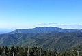
Mount Le Conte in the Great Smoky Mountains is the tallest mountain in eastern North America, measured from base to summit
-

Re-enactment of the Battle of Bean's Station in Bean Station
-
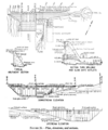
Engineering plans for Norris Dam in Anderson County, which was the first project completed by the TVA in 1936
-

Monument to the twelve African American students who integrated Clinton High School in 1956
-

The 1982 World's Fair in Knoxville was the last successful international exposition held in the U.S.
-
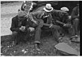
Musicians performing on the streets of Maynardville, circa 1935


