Eastland County, Texas facts for kids
Quick facts for kids
Eastland County
|
|
|---|---|
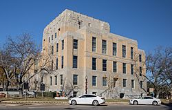
Eastland County Courthouse
|
|
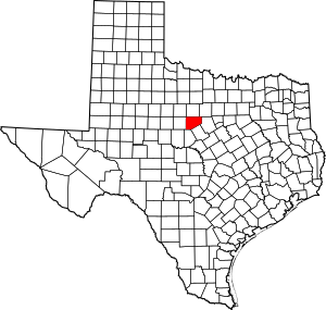
Location within the U.S. state of Texas
|
|
 Texas's location within the U.S. |
|
| Country | |
| State | |
| Founded | 1873 |
| Seat | Eastland |
| Largest city | Eastland |
| Area | |
| • Total | 932 sq mi (2,410 km2) |
| • Land | 926 sq mi (2,400 km2) |
| • Water | 5.4 sq mi (14 km2) 0.6% |
| Population
(2020)
|
|
| • Total | 17,725 |
| • Density | 19.018/sq mi (7.343/km2) |
| Time zone | UTC−6 (Central) |
| • Summer (DST) | UTC−5 (CDT) |
| Congressional district | 11th |
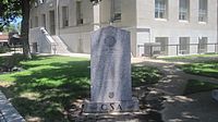
Eastland County is a county located in central West Texas. As of the 2020 census, its population was 17,725. The county seat is Eastland. The county was founded in 1858 and later organized in 1873. It is named for William Mosby Eastland, a soldier during the Texas Revolution and the only officer to die as a result of the "Black Bean executions" of the Mier Expedition.
Two Eastland County communities, Cisco and Ranger, have junior colleges.
Contents
Geography
According to the U.S. Census Bureau, the county has a total area of 932 square miles (2,410 km2), of which 926 square miles (2,400 km2) is land and 5.4 square miles (14 km2) (0.6%) is water.
Major highways
 Interstate 20
 U.S. Highway 183
 State Highway 6
 State Highway 16
 State Highway 36
 State Highway 112
Adjacent counties
- Stephens County (north)
- Palo Pinto County (northeast)
- Erath County (east)
- Comanche County (southeast)
- Brown County (south)
- Callahan County (west)
- Shackelford County (northwest)
Demographics
| Historical population | |||
|---|---|---|---|
| Census | Pop. | %± | |
| 1860 | 99 | — | |
| 1870 | 88 | −11.1% | |
| 1880 | 4,855 | 5,417.0% | |
| 1890 | 10,373 | 113.7% | |
| 1900 | 17,971 | 73.2% | |
| 1910 | 23,421 | 30.3% | |
| 1920 | 58,505 | 149.8% | |
| 1930 | 34,156 | −41.6% | |
| 1940 | 30,345 | −11.2% | |
| 1950 | 23,942 | −21.1% | |
| 1960 | 19,526 | −18.4% | |
| 1970 | 18,092 | −7.3% | |
| 1980 | 19,480 | 7.7% | |
| 1990 | 18,488 | −5.1% | |
| 2000 | 18,297 | −1.0% | |
| 2010 | 18,583 | 1.6% | |
| 2020 | 17,725 | −4.6% | |
| U.S. Decennial Census 1850–2010 2010 2020 |
|||
2020 census
| Race / Ethnicity | Pop 2010 | Pop 2020 | % 2010 | % 2020 |
|---|---|---|---|---|
| White alone (NH) | 15,271 | 13,653 | 82.18% | 77.03% |
| Black or African American alone (NH) | 318 | 335 | 1.71% | 1.89% |
| Native American or Alaska Native alone (NH) | 92 | 96 | 0.50% | 0.54% |
| Asian alone (NH) | 62 | 95 | 0.33% | 0.54% |
| Pacific Islander alone (NH) | 8 | 16 | 0.04% | 0.09% |
| Some Other Race alone (NH) | 8 | 26 | 0.04% | 0.15% |
| Mixed Race/Multi-Racial (NH) | 151 | 570 | 0.81% | 3.22% |
| Hispanic or Latino (any race) | 2,673 | 2,934 | 14.38% | 16.55% |
| Total | 18,583 | 17,725 | 100.00% | 100.00% |
Note: the US Census treats Hispanic/Latino as an ethnic category. This table excludes Latinos from the racial categories and assigns them to a separate category. Hispanics/Latinos can be of any race.
Communities
Cities
Towns
Unincorporated communities
Ghost towns
Education
Despite its small population, the county is home to two community colleges – Cisco College and Ranger College, located in their respective towns.
See also
 In Spanish: Condado de Eastland para niños


