
Edinburg, Virginia facts for kids
Quick facts for kids
Edinburg, Virginia
|
|
|---|---|

The Mill in Edinburg, Virginia (1848).
|
|

Location in Virginia
|
|
| Country | United States |
| State | Virginia |
| County | Shenandoah |
| Founded | 1852 |
| Area | |
| • Total | 0.76 sq mi (1.96 km2) |
| • Land | 0.74 sq mi (1.92 km2) |
| • Water | 0.02 sq mi (0.05 km2) |
| Elevation | 807 ft (246 m) |
| Population
(2010)
|
|
| • Total | 1,041 |
| • Estimate
(2019)
|
1,070 |
| • Density | 1,443.99/sq mi (557.80/km2) |
| Time zone | UTC−5 (Eastern (EST)) |
| • Summer (DST) | UTC−4 (EDT) |
| ZIP code |
22824
|
| Area code(s) | 540 |
| FIPS code | 51-25008 |
| GNIS feature ID | 1494215 |
| Website | http://www.townofedinburg.com |
Edinburg is a town in Shenandoah County, Virginia, United States. The population was 1,041 at the 2010 census.
History
The Bowman-Zirkle Farm, Campbell Farm, Clem-Kagey Farm, Edinburg Historic District, Edinburg Mill, Dr. Christian Hockman House, Lantz Mill, and John Miley Maphis House are listed on the National Register of Historic Places.
Geography
Edinburg is located at 38°49′21″N 78°33′55″W / 38.82250°N 78.56528°W (38.822558, -78.565362).
_between_Saums_Way_and_Center_Street_in_Edinburg,_Shenandoah_County,_Virginia.jpg)
According to the United States Census Bureau, the town has a total area of 0.7 square miles (1.9 km²), all of it land.
Demographics
| Historical population | |||
|---|---|---|---|
| Census | Pop. | %± | |
| 1860 | 514 | — | |
| 1870 | 452 | −12.1% | |
| 1880 | 478 | 5.8% | |
| 1890 | 512 | 7.1% | |
| 1900 | 512 | 0.0% | |
| 1910 | 574 | 12.1% | |
| 1920 | 568 | −1.0% | |
| 1930 | 498 | −12.3% | |
| 1940 | 565 | 13.5% | |
| 1950 | 533 | −5.7% | |
| 1960 | 517 | −3.0% | |
| 1970 | 766 | 48.2% | |
| 1980 | 752 | −1.8% | |
| 1990 | 860 | 14.4% | |
| 2000 | 813 | −5.5% | |
| 2010 | 1,041 | 28.0% | |
| 2019 (est.) | 1,070 | 2.8% | |
| U.S. Decennial Census | |||
As of the census of 2000, 813 people, 385 households, and 220 families resided in the town. The population density was 1,103.2 people per square mile (424.2/km2). There were 425 housing units at an average density of 576.7 per square mile (221.7/km2). The racial makeup of the town was 93.97% White, 0.12% African American, 0.37% Native American, 3.69% from other races, and 1.85% from two or more races. Hispanics or Latinos of any race were 8.73% of the population.
Of 385 households, 20.5% had children under the age of 18 living with them, 42.6% were married couples living together, 9.9% had a female householder with no husband present, and 42.6% were not families. About 35.8% of all households were made up of individuals, and 15.8% had someone living alone who was 65 years of age or older. The average household size was 2.09 and the average family size was 2.71.
In the town, the population was distributed as 18.1% under the age of 18, 8.4% from 18 to 24, 27.6% from 25 to 44, 24.6% from 45 to 64, and 21.4% who were 65 years of age or older. The median age was 41 years. For every 100 females, there were 92.7 males. For every 100 females age 18 and over, there were 88.1 males.
The median income for a household in the town was $30,655, and the median income for a family was $37,986. Males had a median income of $29,000 versus $18,021 for females. The per capita income for the town was $18,993. About 5.4% of families and 10.6% of the population were below the poverty line, including 2.5% of those under age 18 and 21.5% of those age 65 or over.
Transportation
U.S. Route 11 is the main road passing through Edinburg, serving as Main Street. Virginia State Route 185 connects US 11 to Interstate 81, which travels north–south just west of the town limits.
Images for kids
-
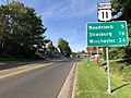
View north along US 11, the primary road through Edinburg
_at_Winifred_Street_in_Edinburg,_Shenandoah_County,_Virginia.jpg)
See also
 In Spanish: Edinburg (Virginia) para niños
