
El Moro, Colorado facts for kids
Quick facts for kids
El Moro, Colorado
|
|
|---|---|

The former El Moro Public School (now privately held).
|
|

Location of the El Moro CDP in Las Animas County, Colorado.
|
|

El Moro, Colorado
Location in the United States
|
|
| Country | |
| State | |
| County | Las Animas County |
| Government | |
| • Type | unincorporated community |
| Area | |
| • Total | 11.116 sq mi (28.791 km2) |
| • Land | 11.091 sq mi (28.725 km2) |
| • Water | 0.025 sq mi (0.066 km2) |
| Elevation | 5,879 ft (1,792 m) |
| Population
(2010)
|
|
| • Total | 221 |
| • Density | 20/sq mi (8/km2) |
| Time zone | UTC-7 (MST) |
| • Summer (DST) | UTC-6 (MDT) |
| ZIP Code |
Trinidad 81082
|
| Area code(s) | 719 |
| GNIS feature | El Moro CDP |
El Moro is an unincorporated community and a census-designated place (CDP) located in and governed by Las Animas County, Colorado, United States. The population of the El Moro CDP was 221 at the United States Census 2010. The Trinidad post office (Zip Code 81082) serves the area.
Demographics
The United States Census Bureau initially defined the El Moro CDP for the United States Census 2010.
| El Moro CDP, Colorado | ||
|---|---|---|
| Year | Pop. | ±% |
| 2010 | 221 | — |
| 2020 | — | |
| Source: United States Census Bureau | ||
Images for kids
-
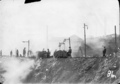
Colorado Fuel & Iron mine at El Moro, c. 1900

See also
 In Spanish: El Moro (Colorado) para niños

All content from Kiddle encyclopedia articles (including the article images and facts) can be freely used under Attribution-ShareAlike license, unless stated otherwise. Cite this article:
El Moro, Colorado Facts for Kids. Kiddle Encyclopedia.