
El Seibo Province facts for kids
Quick facts for kids El Seibo |
||
| Province | ||
|
||
| Country | ||
|---|---|---|
| Development region | Yuma (VIII) | |
| Capital | Santa Cruz del Seibo | |
| - elevation | 110 m (361 ft) | |
| - coordinates | 18°46′50″N 69°2′27″W / 18.78056°N 69.04083°W | |
| Highest point | ||
| - location | Sierra de Neiba | |
| Lowest point | Atlantic Ocean | |
| - elevation | 0 m (0 ft) | |
| Area | 1,788.4 km² (691 sq mi) | |
| Population | 110,212 (2014) | |
| Density | 62 /km² (161 /sq mi) | |
| Province since | 1844 | |
| Subdivisions | 2 municipalities 5 municipal districts |
|
| Congresspersons | 1 Senator 2 Representatives |
|
| Timezone | EST (UTC-4) | |
| Area code | 1-809 1-829 1-849 | |
| ISO 3166-2 | DO-08 | |

El Seibo is a Dominican province in the eastern part of the country. Its capital city is Santa Cruz del Seibo.
It was one of the first provinces in the country; the first Dominican constitution made it in 1844 one of the five original provinces of the country. Its name has always been El Seibo, written sometimes as El Seybo.
Contents
Name
The province takes the name from its main city: El Seibo.
Location
The El Seibo province has the La Altagracia province to the east, the San Pedro de Macorís province to the south and the Hato Mayor province to the west. To the north of the El Seibo province is the Samaná Bay, part of the Atlantic Ocean.
 |
Samaná Bay | Atlantic Ocean | |
|
| Hato Mayor province | La Altagracia province | |||
| San Pedro de Macorís province |
History
On 24 July 1844, after the Dominican independence, the government made five departments (another name for province); one of those departments was the El Seibo Department, with the municipalities of El Seibo, Hato Mayor, Higüey and Samaná. The first Dominican constitution kept that division but as provinces instead of departments.
The original province had all the eastern part of the Hispaniola, including the Samaná peninsula. But soon the province was reduced to make new provinces. The first two new provinces made with land of El Seibo province were Samaná in 1865, and San Pedro de Macorís in 1882.
In 1961, the old La Altagracia province, that later was divided in La Altagracia and La Romana provinces, was made out of the El Seibo province. The last province made with part of El Seibo was Hato Mayor in 1984.
People from this province took part in the war against Haiti during the Independence War; the leader was Pedro Santana, who had a farm near to the city of El Seibo and who became the first president of the country.
Before that, people from El Seibo fought against the French army. The most important battle was the Palo Hincado Battle won by the Dominican people on 7 November 1808, in a savanna (Palo Hincado Savanna) just to the east of Santa Cruz del Seibo. Soon the French had to leave the country, and the whole island; they had lost Haiti, too.
The municipal districts of the province were created in:
- 1997 : Pedro Sánchez
- 2001 : El Cedro
- 2005 : La Gina
- 2006 : San Francisco-Vicentillo and Santa Lucía
Population
In 2014 (last national census), there were 110,212 people living in the El Seibo province, and 45,103 (40.9%) living in towns and cities. The population density was 61.6 persons/km², one of the lowest in the country.
Its population represents 1.17% of the total population of the country and the province is ranked as the 25th (out of 31 plus the National District) more populated province.
As of 2016[update], the total estimated propulation of the province is 91,256 inhabitants.
The largest city of the province is Santa Cruz del Seibo, its head municipality or capital, with an urban population (in 2010) of 26,477 inhabitants.
Geography
El Seibo has a total area of 1,788.4 km2 (690.5 sq mi). It has 3.7% of the area of the Dominican Republic and it is ranked as the 11th (out of 31 plus the National District) largest province of the country.
There are at least three geographic regions in the province. From north to south, they are:
- Coastal plains. Small plains along the Atlantic coast.
- Cordillera Oriental (in English: "Eastern mountain range"). A mountain range with low mountains.
- Llano Costero del Caribe (in English, "Caribbean Coastal Plain"), a large prairie with big important savannas.
The River Soco is the most important river of the province; it flows from the Cordillera Oriental to the Caribbean Sea.
The only main road in the province is the Carretera Mella (Mella National Road) that goes through the middle of the province; the road comes from Santo Domingo and goes through the cities of Hato Mayor and Santa Cruz del Seibo and ends in Higüey.
Municipalities
There are 2 municipalities and 5 municipal districts (M.D.) in the province. The municipalities and its municipal districts (M.D.) are:
| Municipality (code) | Municipal Districts (code) | Population (2010) |
Area (km2) |
Density | Altitude (m) |
|---|---|---|---|---|---|
| Santa Cruz del Seibo (080101) | 46,285 | 886.3 | 52.2 | 110 | |
| Pedro Sánchez (080102) | 4,245 | 117.1 | 36.3 | 156 | |
| San Francisco-Vicentillo (080103) | 4,524 | 200.3 | 22.6 | 198 | |
| Santa Lucía (080104) | 11,742 | 141.0 | 83.3 | 194 | |
| Santa Cruz del Seibo (080100) | 66,867 | 1,344.6 | 49.7 | ||
| Miches (080201) | 10,152 | 93.6 | 108.5 | 16 | |
| El Cedro (080202) | 7,539 | 285.8 | 26.4 | 15 | |
| La Gina (080203) | 3,122 | 64.4 | 48.5 | 73 | |
| Miches (080200) | 20,813 | 443.8 | 46.9 | ||
| El Seibo province (080000) | 87,680 | 1,788.4 | 49.0 | ||
Economy
Cattle raising is the most important activity in the province. Sugar cane and cacao are the most important crops.
Related pages
Images for kids
-
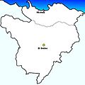
Municipalities of El Seibo Province, Dominican Republic.
-
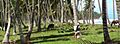
Miches, El Seibo, Dominican Republic beach.

See also
 In Spanish: Provincia de El Seibo para niños
