
Elephant Butte Dam facts for kids
Quick facts for kids Elephant Butte Dam |
|
|---|---|

The dam and reservoir at highstand
|
|
| Country | United States |
| Location | Elephant Butte, New Mexico |
| Coordinates | 33°09′14″N 107°11′32″W / 33.153969°N 107.192113°W |
| Status | In use |
| Construction began | 1911 |
| Opening date | 1916 |
| Owner(s) | U.S. Bureau of Reclamation |
| Dam and spillways | |
| Type of dam | Gravity |
| Impounds | Rio Grande |
| Height | 301 ft (92 m) |
| Length | 1,674 ft (510 m) |
| Width (crest) | 18 ft (5 m) |
| Width (base) | 228 ft (69 m) |
| Dam volume | 618,785 cu yd (473,095 m3) |
| Spillway type | Concrete chute |
| Reservoir | |
| Creates | Elephant Butte Lake |
| Total capacity | 2,065,010 acre⋅ft (2.547152329×10⁹ m3) |
| Catchment area | 28,900 sq mi (75,000 km2) |
| Surface area | 36,500 acres (14,800 ha) |
| Power station | |
| Hydraulic head | 140 ft (43 m) (rated) |
| Turbines | 1 x Francis turbine |
| Installed capacity | 27.95 MW |
| Annual generation | 38,449,061 kWh |
|
Elephant Butte Dam
|
|

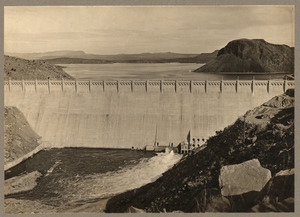
The spillway is in the lower left corner of the picture and the power plant is located at the base of the opposite side of the dam.
|
|
| Lua error in Module:Location_map at line 420: attempt to index field 'wikibase' (a nil value). | |
| Nearest city | Elephant Butte, New Mexico |
| Area | 45 acres (18 ha) |
| Built | 1910 |
| Architect | Louis C. Hill |
| Architectural style | Gravity-type |
| NRHP reference No. | 79001556 |
| Significant dates | |
| Added to NRHP | April 9, 1979 |
Elephant Butte Dam or Elephant Butte Dike, originally Engle Dam, is a concrete gravity dam on the Rio Grande near Truth or Consequences, New Mexico. The dam impounds Elephant Butte Reservoir, which is used mainly for agriculture, and also provides for recreation, hydroelectricity, and flood and sediment control. The construction of the dam has reduced the flow of the Rio Grande to a small stream for most of the year, with water released only during the summer irrigation season, or during times of exceptionally heavy snow melt.
Name and etymology
Elephant Butte is an exposed volcanic plug in Sierra County, New Mexico. The sides of the volcano have eroded away leaving only the solidified butte-shaped core. It is now an island in the lake, except at low water levels, when it is connected to land by an isthmus. The butte was said to have the shape of an elephant lying on its side. This name was applied to the area since before the dam's construction. The nearby city of Elephant Butte was named for this rock formation.
The original name of the dam was Engle Dam, named after the nearby railroad stop at Engel, New Mexico. The stop was named "Engle" after construction engineer R.L. Engle, and later renamed "Engel" by the Santa Fe Railroad after their company vice president Edward Engel. Locals complained to Congress about the name change, but were unsuccessful in having the name reverted.
Another name proposed for the dam and used in at least one publication was "Woodrow Wilson Dam", after the former president of the United States.

History
Drought and floods
Like many rivers of the American Southwest, runoff in the Rio Grande basin is limited and varies widely from year to year, alternating between devastating droughts and destructive floods. In the 1880s, farmers in the region began to complain that they were not receiving a fair appropriation of river water. By the 1890s, water use in the upper basin was so great that the river's flow near El Paso, Texas, was reduced to "a trickle in dry summers".
To resolve these problems, plans were drafted up for a large storage dam at Elephant Butte, about 130 miles (210 km) downstream of Albuquerque, New Mexico. The first to propose a dam for the area were Peter E. Kern, E.V. Berrien, John Campbell, R.M. Loomis and Edward Roberts. They had camped in the area where the dam is now, and although Kern encouraged the others to consider building a dam there, its construction was delayed by legal battles relating to the final site and water rights.

A site lower far downriver, at the El Paso narrows, was considered for a dam, but would have flooded a large area of the lower Mesilla Valley and would have interfered with railway and other transportation.
A private dam project backed by British investors was in the works in 1894 just upstream from the dam site. the project was also backed by the U.S. Department of the Interior. It was eventually blocked by the U.S. Secretary of State, "on basis of a technicality that the Rio Grande was arguably a navigable river and permission from the War Department was also needed." Although delayed by legal issues, the injunction against building the dam was lifted in 1897. However, the project failed to proceed, and the investors lost their rights to build the private dam in 1903.
Construction
The United States Congress passed the Newlands Reclamation Act in 1902, authorizing the Rio Grande Project to provide power and irrigation to south-central New Mexico and west Texas as a Bureau of Reclamation undertaking. For the next two years, surveyors and engineers undertook a comprehensive feasibility study for the project's dams and reservoirs. Construction of the dam was authorized on February 25, 1905 and it began in 1911.
To accommodate the dam's construction, crews built and improved roads, and constructed a Bureau of Reclamation office, water tanks, worker camps, a machine shop, a power plant, and a hospital. A system of 3 cables, each having a capacity of 15 tons and a span of 1,400 feet (430 m) was suspended across the canyon over the site.
At its peak, the camps housed around 3,500 workers. Two worker camps housed them. The "Upper Camp" was built upstream and housed affluential and skilled workers, such as supervisors, and engineers. The "Lower Camp" was downstream of the site and housed the less affluential laborers. The Lower Camp was further segregated, with American and Mexican workers living in separate areas of the camp. Upper camp was inundated by the dam's own reservoir, while, although on dry land, no trace of Lower Camp remains.
At the time of its construction, the dam was the largest irrigation dam ever built with the exception of the Aswan Dam in Egypt, and impounded the world's largest man-made lake. It was expected that the dam would become the property of the local settlers once a water tax had reimbursed the government for the cost of construction.
The dam and Bureau of Reclamation office were listed on the U.S. National Register of Historic Places in 1979. Historic resources from the era of construction of the dam, and from New Deal era development of power generation and recreation facilities in the area, are recognized in the 1997 listing of a 2,443 acres (9.89 km2) area on the National Register as the Elephant Butte Historic District. The historic district listing includes the dam and surrounding historic structures.
Characteristics
Elephant Butte Dam is 301 feet (91.7 m) high, 1,674 feet (510.2 m) long including the spillway and is made from 618,785 cubic yards (473,095 m³) of concrete. The width at the top of the dam is 18 feet (5.5 m) and 228 feet (69.5 m) at the base.

The reservoir has a capacity of 2,065,010 acre-feet (2.54715×10⁹ m3) of water and controls the runoff from 28,900 square miles (74,850 km²). It provides irrigation to 178,000 acres (720 km²) of land. The dam also contains a 28 megawatt hydroelectric powerplant. The current turbine was installed in 1940 and generates 38,449,061 kWh per year (as of 2005). The crest elevation is 4390 ft (1338 m).
