
Elevation facts for kids

When talking about geography the elevation of a certain point is how high it is compared to some reference point. Very often, the reference point is mean sea level, the level of the ocean midway between high and low tide on an average day. Most land has a positive elevation, which means it is above sea level. A few desert places are below sea level, thus have negative elevation.
Sometimes elevation is measured against the center of the earth. The problem there is that the earth does not really look like a ball, it is slightly squashed (an oblate spheroid). This means, that while still at mean sea level (at the equator), some points are father away from the center of the earth than others. That way the peak of Chimborazo, a volcano in Ecuador is farther away from the center of the earth than the peak of Mount Everest. Yet, Mount Everest is higher above sea level.
Related pages
Images for kids
-
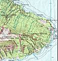
Part of a topographic map of Haleakala (Hawaii), showing elevation.
-
Heightmap of Earth's surface (including water and ice) in equirectangular projection, normalized as 8-bit grayscale, where lighter values indicate higher elevation.


See also
 In Spanish: Elevación (ubicación geográfica) para niños
