
Eliot, Maine facts for kids
Quick facts for kids
Eliot, Maine
|
|
|---|---|

Welcome to Historic Eliot sign on ME Rt. 103 in South Eliot
|
|

Eliot, Maine
Location in Maine
|
|
| Country | United States |
| State | Maine |
| County | York |
| Incorporated | 1810 |
| Government | |
| • Type | Town Meeting |
| Area | |
| • Total | 21.32 sq mi (55.22 km2) |
| • Land | 19.78 sq mi (51.23 km2) |
| • Water | 1.54 sq mi (3.99 km2) |
| Elevation | 20 ft (6 m) |
| Population
(2020)
|
|
| • Total | 6,717 |
| • Density | 340/sq mi (131.1/km2) |
| Time zone | UTC-5 (Eastern (EST)) |
| • Summer (DST) | UTC-4 (EDT) |
| ZIP code |
03903
|
| Area code(s) | 207 |
| FIPS code | 23-22955 |
| GNIS feature ID | 0582464 |
Eliot is a town in York County, Maine, United States. Originally settled in 1623, it was formerly a part of Kittery, Maine to its east. After Kittery it is the next most southern town in the state of Maine, lying on the Piscataqua River across from Portsmouth and Newington, New Hampshire. The population was 6,717 at the 2020 census. It is part of the Portland–South Portland–Biddeford, Maine metropolitan statistical area.
Eliot is home to Ambush Rock, Green Acre and the Raitt Homestead Farm Museum.
Contents
History
The honor of naming the town is sometimes given to Alexander Shapleigh who was reportedly born around 1574 at the Manor of Kittery Court in Devon, England. Kittery Court is located in the village of Kingsweare, across the river Dart from the city of Dartmouth. Dartmouth, New Hampshire, of course, and Exeter and Appledore are also local place names borrowed from this region in the county of Devon. In England the Shapleights were merchants and a major importer of salt from France. It was a natural step to become involved in the fishing industry in which salted fish were imported from the Atlantic coast of America. Alexander arrived in the New World in 1635 aboard his ship BENEDICTION that he co-owned with business partner Captain Francis Champernowne, a relative of Sir Walter Scott. Like the Pepperrells of Kittery, they also set up a salt fish operation at the Isles of Shoals and exported the popular product to Europe.
ALEXANDER SHAPLEIGH(1), the pioneer of the American Branch of the Family, was born apparently at Kingsweare, Devon, England, about 1574, and was probably the son of Nicholas Shapleigh, of that place, but of this we are not quite sure. His beautiful residence at Kingsweare was called Kittery House. A name that had come down in the Shapleigh family for several generations, and the name, followed the family to America and finally gave name to the Town of Kittery, Maine. From the testimony of Katherine Treworgy, we learn that Alexander Shapleigh was alive May 26, 1642. We hear nothing more about him, and we learn from the court records that he was dead previous to July 5, 1650.
The town Kittery, Maine, was incorporated in 1647, and today bills itself as "the oldest incorporated town in Maine." It was named after the birthplace of a founder, Alexander Shapleigh, from the manor of Kittery Court at Kingswear in Devon, England. Shapleigh arrived in 1635 aboard the ship Benediction, which he co-owned with another prominent settler, Captain Francis Champernowne. Together with the Pepperrell family, they established fisheries offshore at the Isles of Shoals, where fish were caught, salted and exported back to Europe. Other pioneers were hunters, trappers and workers of the region's abundant timber. Kittery's original land area extended from the Atlantic Ocean inland up the Salmon Falls River, including the present-day towns of Eliot, Berwick, South Berwick and North Berwick.
Kittery Court (also called Kittery Quay) still survives and is on the list of sites to visit in Kingsweare. That also boasts a mediaeval castle. Today a car ferry runs from Kingsware to Dartmouth and the sleepy village is a popular tourist spot. Visitors can also take a steam railroad train along the scenic winding coast. Originally part of the Piscataqua Plantation (renamed Kittery in 1647) called Sturgeon Creek in the 1630-40s, it became the North, or Second, Parish of Kittery in 1713 following the incorporation of Berwick. On March 1, 1810, Eliot became a town. Prior to its incorporation as a town, the Second Parish had been in conflict with Kittery's other parishes since at least 1791. In 1791, the parish's minister died. His successor, according to a large faction of the parish's inhabitants, was a man of "unfair character" imposed by "a small party" of people. He was rejected by "a large majority", and a new minister was installed in 1792. The internal strife between inhabitants didn't stop there.
The minority faction, angered by the removal of their minister, "petitioned the Legislature in...1796 to be set off to the third parish, which was accordingly done." The inhabitants of the second Parish accused the members of the other two of conspiring against them.
The town was either named after Robert Eliot, who was a member of the Provincial Council of New Hampshire, or for Reverend John Eliot of Boston, a friend of General Andrew P. Fernald, the town agent largely responsible for its separation.
Geography
According to the United States Census Bureau, the town has a total area of 21.32 square miles (55.22 km2), of which, 19.78 square miles (51.23 km2) of it is land and 1.54 square miles (3.99 km2) is water. Eliot is drained by Sturgeon Creek and the Piscataqua River.
Eliot is served by state routes 91, 101, 103 and 236. The town is northwest of Interstate 95 and near the New Hampshire border.
Demographics
| Historical population | |||
|---|---|---|---|
| Census | Pop. | %± | |
| 1810 | 1,650 | — | |
| 1820 | 1,679 | 1.8% | |
| 1830 | 1,845 | 9.9% | |
| 1840 | 1,889 | 2.4% | |
| 1850 | 1,803 | −4.6% | |
| 1860 | 1,767 | −2.0% | |
| 1870 | 1,769 | 0.1% | |
| 1880 | 1,640 | −7.3% | |
| 1890 | 1,463 | −10.8% | |
| 1900 | 1,458 | −0.3% | |
| 1910 | 1,530 | 4.9% | |
| 1920 | 1,530 | 0.0% | |
| 1930 | 1,462 | −4.4% | |
| 1940 | 1,932 | 32.1% | |
| 1950 | 2,509 | 29.9% | |
| 1960 | 3,133 | 24.9% | |
| 1970 | 3,497 | 11.6% | |
| 1980 | 4,948 | 41.5% | |
| 1990 | 5,329 | 7.7% | |
| 2000 | 5,954 | 11.7% | |
| 2010 | 6,204 | 4.2% | |
| 2020 | 6,717 | 8.3% | |
| U.S. Decennial Census | |||
As of 2000 the median income for a household in the town was $52,606, and the median income for a family was $63,598. Males had a median income of $44,205 versus $30,530 for females. The per capita income for the town was $24,403. About 5.2% of families and 5.8% of the population were below the poverty line, including 7.1% of those under age 18 and 3.5% of those age 65 or over.
2010 census
As of the census of 2010, there were 6,204 people, 2,509 households, and 1,783 families residing in the town. The population density was 313.7 inhabitants per square mile (121.1/km2). There were 2,669 housing units at an average density of 134.9 per square mile (52.1/km2). The racial makeup of the town was 96.8% White, 0.7% African American, 0.1% Native American, 0.5% Asian, 0.3% from other races, and 1.5% from two or more races. Hispanic or Latino of any race were 1.2% of the population.
There were 2,509 households, of which 31.7% had children under the age of 18 living with them, 59.0% were married couples living together, 8.3% had a female householder with no husband present, 3.7% had a male householder with no wife present, and 28.9% were non-families. 23.4% of all households were made up of individuals, and 10.1% had someone living alone who was 65 years of age or older. The average household size was 2.47 and the average family size was 2.89.
The median age in the town was 45.4 years. 22.1% of residents were under the age of 18; 5.9% were between the ages of 18 and 24; 21.3% were from 25 to 44; 36.1% were from 45 to 64; and 14.6% were 65 years of age or older. The gender makeup of the town was 48.8% male and 51.2% female.
Sites of interest
- Green Acre
- Frost Garrison and House, Frost’s Hill (See Charles Frost (military officer))
- Paul Family Farm, 106 Depot Road
- Fogg House
Education SAD35 (Eliot, South Berwick, and Rollinsford)
- Eliot Elementary School
- Central School
- Great Works School
- Marshwood Middle School
Notable people
- Shem Drowne, coppersmith, America's first documented weathervane maker
- Moses Gerrish Farmer, inventor
- Charles Frost, Colonial Military Leader
- John Fremont Hill, state congressmen and US senator, 45th governor of Maine (1901–1905)
Images for kids
-

William Fogg Library
-
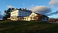
Green Acre
-
Sanctuary Arts studio
-

Frost House
-

Eliot Elementary School
-

Eliot Town Hall
-

Paul Family Farm
-

Sunset over the Piscataqua River on the Long Reach, Eliot on right, September 2014


.jpg)
See also
 In Spanish: Eliot (Maine) para niños
