Ellaville, Georgia facts for kids
Quick facts for kids
Ellaville, Georgia
|
|
|---|---|

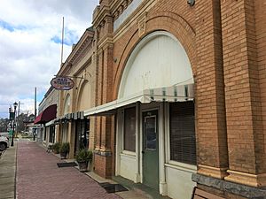
Main Street in Ellaville
|
|

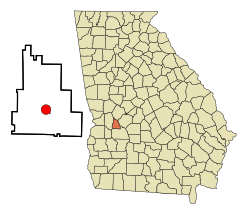
Location in Schley County and the state of Georgia
|
|
| Country | United States |
| State | Georgia |
| County | Schley |
| Area | |
| • Total | 3.18 sq mi (8.22 km2) |
| • Land | 3.16 sq mi (8.19 km2) |
| • Water | 0.01 sq mi (0.04 km2) |
| Elevation | 571 ft (174 m) |
| Population
(2020)
|
|
| • Total | 1,595 |
| • Density | 504.75/sq mi (194.86/km2) |
| Time zone | UTC-5 (Eastern (EST)) |
| • Summer (DST) | UTC-4 (EDT) |
| ZIP code |
31806
|
| Area code(s) | 229 |
| FIPS code | 13-26980 |
| GNIS feature ID | 0355674 |
Ellaville is a city in Schley County, Georgia, United States. The population was 1,812 at the 2010 census. The city is the county seat of Schley County.
Ellaville is part of the Americus Micropolitan Statistical Area.
Contents
History
A town named Pond Town was established in 1812 along the stage coach in the area that is now the location of the Ellaville City Cemetery. Thea area was then part of the lands belonging to the Muscogee (Creek) Nation. In 1821, after the Treaty of Indian Springs the area became part of the state of Georgia. In 1826, it served as temporary county seat for Lee County, Georgia upon the creation of the then vast county. Pond Town soon became a lively town noted for horse racing and whiskey. In 1831, the area became part of Sumter County, Georgia. In 1840, twenty families migrated to Mississippi, which began the process of depopulating the town.
Ellaville was founded in 1857 as county seat of the newly formed Schley County. It was incorporated as a town in 1859. Several families from Pond Town moved their houses the half mile distance to the new town. In August 1859, the post office was changed from Pond Town to Ellaville.
Geography
Ellaville is located at 32°14′20″N 84°18′34″W / 32.23889°N 84.30944°W (32.238921, -84.309526).
According to the United States Census Bureau, the city has a total area of 3.2 square miles (8.3 km2), all of it land.
Demographics
| Historical population | |||
|---|---|---|---|
| Census | Pop. | %± | |
| 1880 | 182 | — | |
| 1900 | 474 | — | |
| 1910 | 672 | 41.8% | |
| 1920 | 693 | 3.1% | |
| 1930 | 764 | 10.2% | |
| 1940 | 928 | 21.5% | |
| 1950 | 886 | −4.5% | |
| 1960 | 905 | 2.1% | |
| 1970 | 1,391 | 53.7% | |
| 1980 | 1,684 | 21.1% | |
| 1990 | 1,724 | 2.4% | |
| 2000 | 1,609 | −6.7% | |
| 2010 | 1,812 | 12.6% | |
| 2020 | 1,595 | −12.0% | |
| U.S. Decennial Census | |||
2020 census
| Race | Num. | Perc. |
|---|---|---|
| White (non-Hispanic) | 951 | 59.62% |
| Black or African American (non-Hispanic) | 507 | 31.79% |
| Native American | 1 | 0.06% |
| Asian | 7 | 0.44% |
| Pacific Islander | 2 | 0.13% |
| Other/Mixed | 51 | 3.2% |
| Hispanic or Latino | 76 | 4.76% |
As of the 2020 United States census, there were 1,595 people, 610 households, and 438 families residing in the city.
Education
Schley County School District
The Schley County School District holds pre-school to grade twelve, and consists of one elementary school and one middle-high school. The district has 66 full-time teachers and over 1,126 students.
- Schley County Elementary School
- Schley Middle High School
Infrastructure
Ellaville is served by U.S. Route 19, Georgia State Route 26 and Georgia State Route 153.
Notable people
- Charles Frederick Crisp, Speaker of the United States House of Representatives
- William J. Sears, Congressman from Florida
- Brent Cobb, singer
- Caylee Hammack, singer
- Blaire Erskine, comedian
See also
 In Spanish: Ellaville para niños

