
Elmdale, Kansas facts for kids
Quick facts for kids
Elmdale, Kansas
|
|
|---|---|
.jpg)
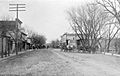
Elmdale, 2011
|
|

Location within Chase County and Kansas
|
|

|
|
| Country | United States |
| State | Kansas |
| County | Chase |
| Township | Diamond Creek |
| Incorporated | 1899 |
| Government | |
| • Type | Mayor–Council |
| Area | |
| • Total | 0.17 sq mi (0.43 km2) |
| • Land | 0.17 sq mi (0.43 km2) |
| • Water | 0.00 sq mi (0.00 km2) |
| Elevation | 1,201 ft (366 m) |
| Population
(2020)
|
|
| • Total | 40 |
| • Density | 240/sq mi (93/km2) |
| Time zone | UTC-6 (CST) |
| • Summer (DST) | UTC-5 (CDT) |
| ZIP code |
66850
|
| Area code | 620 |
| FIPS code | 20-20675 |
| GNIS ID | 477256 |
Elmdale is a city in Chase County, Kansas, United States. As of the 2020 census, the population of the city was 40. It is located along U.S. Route 50 highway.
Contents
History

Early history
For many millennia, the Great Plains of North America was inhabited by nomadic Native Americans. From the 16th century to 18th century, the Kingdom of France claimed ownership of large parts of North America. In 1762, after the French and Indian War, France secretly ceded New France to Spain, per the Treaty of Fontainebleau.
19th century
In 1802, Spain returned most of the land to France. In 1803, most of the land for modern day Kansas was acquired by the United States from France as part of the 828,000 square mile Louisiana Purchase for 2.83 cents per acre.
In 1806, Zebulon Pike led the Pike expedition westward from St Louis, Missouri, of which part of their journey followed the Cottonwood River through Chase County near the current city of Elmdale.
In 1854, the Kansas Territory was organized, then in 1861 Kansas became the 34th U.S. state. In 1859, Chase County was established within the Kansas Territory, which included the land for modern day Elmdale.
In 1871, the Atchison, Topeka and Santa Fe Railway built a main line east-west through Elmdale. In 1996, it merged with Burlington Northern Railroad and renamed to the current BNSF Railway. Most locals still refer to this railroad as the "Santa Fe".
In 1873, a post was relocated from Middle Creek (an extinct town), to the rail community of Elmdale.
20th century
Elmdale was incorporated in 1904.
In 1916, Camp Wood YMCA was built about 1.5 miles south of Elmdale.
There have been numerous floods during the history of Elmdale. In June and July 1951, due to heavy rains, rivers and streams flooded numerous cities in Kansas, including Elmdale. Many reservoirs and levees were built in Kansas as part of a response to the Great Flood of 1951. A levy was built and saved the town from numerous floods, but in 1998 a flood went over the levy.
In 1967, the high school closed, then later the grade school. All students currently attend schools in Cottonwood Falls.
Geography
Elmdale is located at 38°22′23″N 96°38′46″W / 38.37306°N 96.64611°W (38.372994, -96.645976), in the scenic Flint Hills of the Great Plains. According to the United States Census Bureau, the city has a total area of 0.17 square miles (0.44 km2), all of it land. The Cottonwood River is approximately 0.5 miles east of the city.
Climate
The climate in this area is characterized by hot, humid summers and generally mild to cool winters. According to the Köppen Climate Classification system, Elmdale has a humid subtropical climate, abbreviated "Cfa" on climate maps.
Area attractions
Elmdale has one building on the National Register of Historic Places (NRHP).
- Clover Cliff Ranch House (NRHP).
Demographics
| Historical population | |||
|---|---|---|---|
| Census | Pop. | %± | |
| 1880 | 95 | — | |
| 1910 | 253 | — | |
| 1920 | 248 | −2.0% | |
| 1930 | 246 | −0.8% | |
| 1940 | 239 | −2.8% | |
| 1950 | 180 | −24.7% | |
| 1960 | 114 | −36.7% | |
| 1970 | 102 | −10.5% | |
| 1980 | 109 | 6.9% | |
| 1990 | 83 | −23.9% | |
| 2000 | 50 | −39.8% | |
| 2010 | 55 | 10.0% | |
| 2020 | 40 | −27.3% | |
| U.S. Decennial Census | |||
Elmdale is part of the Emporia Micropolitan Statistical Area.
2010 census
As of the census of 2010, there were 55 people, 23 households, and 11 families residing in the city. The population density was 323.5 inhabitants per square mile (124.9/km2). There were 27 housing units at an average density of 158.8 per square mile (61.3/km2). The racial makeup of the city was 96.4% White and 3.6% from two or more races. Hispanic or Latino of any race were 9.1% of the population.
There were 23 households, of which 26.1% had children under the age of 18 living with them, 39.1% were married couples living together, 4.3% had a female householder with no husband present, 4.3% had a male householder with no wife present, and 52.2% were non-families. 43.5% of all households were made up of individuals, and 13% had someone living alone who was 65 years of age or older. The average household size was 2.39 and the average family size was 3.09.
The median age in the city was 45.3 years. 23.6% of residents were under the age of 18; 9.1% were between the ages of 18 and 24; 16.3% were from 25 to 44; 38.2% were from 45 to 64; and 12.7% were 65 years of age or older. The gender makeup of the city was 56.4% male and 43.6% female.
Education
The community is served by Chase County USD 284 public school district. It has two schools.
- Chase County Junior/Senior High School, 600 Main St in Cottonwood Falls.
Before the creation of USD 284, the Elmdale Cougars won the Kansas State High School class B baseball championship in 1961. In 1967, the high school closed, then later the grade school.
Infrastructure
Transportation
U.S. Route 50 highway and BNSF Railway pass through the city.
Images for kids
-
Main Street, 1911
.jpg)
See also
 In Spanish: Elmdale (Kansas) para niños
