
Elmer, New Jersey facts for kids
Quick facts for kids
Elmer, New Jersey
|
|
|---|---|
|
Borough
|
|
| Borough of Elmer | |

David V. Smith House
|
|
| Nickname(s):
"The Small Town with the Big Welcome"
|
|

Location within Salem County
|
|

Census Bureau map
|
|

Elmer, New Jersey
Location in New Jersey

Elmer, New Jersey
Location in the United States
|
|
| Country | |
| State | |
| County | |
| Incorporated | January 28, 1893 |
| Named for | Lucius Elmer |
| Government | |
| • Type | Borough |
| • Body | Borough Council |
| Area | |
| • Total | 0.91 sq mi (2.37 km2) |
| • Land | 0.89 sq mi (2.31 km2) |
| • Water | 0.02 sq mi (0.05 km2) 2.20% |
| Area rank | 513th of 565 in state 14th of 15 in county |
| Elevation | 115 ft (35 m) |
| Population | |
| • Total | 1,395 |
| • Estimate
(2019)
|
1,308 |
| • Rank | 520th of 566 in state 14th of 15 in county |
| • Density | 1,612.3/sq mi (622.5/km2) |
| • Density rank | 324th of 566 in state 4th of 15 in county |
| Time zone | UTC−05:00 (Eastern (EST)) |
| • Summer (DST) | UTC−04:00 (Eastern (EDT)) |
| ZIP Code |
08318
|
| Area code(s) | 856 |
| FIPS code | 3403321240 |
| GNIS feature ID | 885206 |
| Website | |
Elmer is a borough in Salem County in the U.S. state of New Jersey. As of the 2010 United States Census, the borough's population was 1,395, reflecting an increase of 11 (+0.8%) from the 1,384 counted in the 2000 Census, which had in turn declined by 187 (-11.9%) from the 1,571 counted in the 1990 Census. It is the home of the annual Appel Farm Arts and Music Festival, which celebrated its 23rd year in 2012.
Contents
History
Elmer was incorporated as a borough by an act of the New Jersey Legislature on January 28, 1893, from portions of Pittsgrove Township and Upper Pittsgrove Township, based on the results of a referendum held four days earlier. The borough was named for Lucius Elmer a former judge who helped obtain a post office for the community during his service as Congressman.
Elmer is a dry town where alcohol cannot be sold.
Geography
According to the United States Census Bureau, the borough had a total area of 0.877 square miles (2.273 km2), including 0.865 square miles (2.241 km2) of land and 0.012 square miles (0.032 km2) of water (1.40%).
The borough borders Pittsgrove Township and Upper Pittsgrove Township.
Demographics
| Historical population | |||
|---|---|---|---|
| Census | Pop. | %± | |
| 1880 | 345 | — | |
| 1890 | 842 | 144.1% | |
| 1900 | 1,140 | 35.4% | |
| 1910 | 1,167 | 2.4% | |
| 1920 | 1,115 | −4.5% | |
| 1930 | 1,219 | 9.3% | |
| 1940 | 1,344 | 10.3% | |
| 1950 | 1,460 | 8.6% | |
| 1960 | 1,505 | 3.1% | |
| 1970 | 1,592 | 5.8% | |
| 1980 | 1,569 | −1.4% | |
| 1990 | 1,571 | 0.1% | |
| 2000 | 1,384 | −11.9% | |
| 2010 | 1,395 | 0.8% | |
| 2019 (est.) | 1,308 | −6.2% | |
| Population sources: 1880-1890 1900-2000 1900-1920 1900-1910 1910-1930 1900-2010 2000 2010 |
|||
Census 2010
As of the census of 2010, there were 1,395 people, 536 households, and 391 families residing in the borough. The population density was 1,612.3 per square mile (622.5/km2). There were 577 housing units at an average density of 666.9 per square mile (257.5/km2)*. The racial makeup of the borough was 94.05% (1,312) White, 2.15% (30) Black or African American, 0.57% (8) Native American, 0.79% (11) Asian, 0.00% (0) Pacific Islander, 1.29% (18) from other races, and 1.15% (16) from two or more races. [[Hispanic (U.S. Census)|Hispanic or Latino of any race were 3.15% (44) of the population.
There were 536 households out of which 31.3% had children under the age of 18 living with them, 51.5% were married couples living together, 13.6% had a female householder with no husband present, and 27.1% were non-families. 22.2% of all households were made up of individuals, and 9.3% had someone living alone who was 65 years of age or older. The average household size was 2.60 and the average family size was 3.00.
In the borough, the population was spread out with 22.8% under the age of 18, 8.3% from 18 to 24, 28.5% from 25 to 44, 26.5% from 45 to 64, and 14.0% who were 65 years of age or older. The median age was 39.1 years. For every 100 females there were 95.7 males. For every 100 females ages 18 and old there were 96.5 males.
The Census Bureau's 2006-2010 American Community Survey showed that (in 2010 inflation-adjusted dollars) median household income was $65,417 (with a margin of error of +/- $8,616) and the median family income was $78,661 (+/- $5,812). Males had a median income of $51,685 (+/- $7,458) versus $41,042 (+/- $9,148) for females. The per capita income for the borough was $29,065 (+/- $2,585). About 7.8% of families and 6.5% of the population were below the poverty line, including 8.7% of those under age 18 and 6.8% of those age 65 or over.
Census 2000
As of the 2000 United States Census there were 1,384 people, 524 households, and 385 families residing in the borough. The population density was 1,599.5 people per square mile (614.2/km2). There were 557 housing units at an average density of 643.7 per square mile (247.2/km2). The racial makeup of the borough was 97.25% White, 0.65% African American, 0.51% Asian, 0.72% from other races, and 0.87% from two or more races. Hispanic or Latino of any race were 1.52% of the population.
There were 524 households, out of which 35.7% had children under the age of 18 living with them, 58.0% were married couples living together, 11.6% had a female householder with no husband present, and 26.5% were non-families. 22.3% of all households were made up of individuals, and 10.1% had someone living alone who was 65 years of age or older. The average household size was 2.61 and the average family size was 3.06.
In the borough the population was spread out, with 24.4% under the age of 18, 8.6% from 18 to 24, 29.8% from 25 to 44, 21.7% from 45 to 64, and 15.5% who were 65 years of age or older. The median age was 37 years. For every 100 females, there were 94.1 males. For every 100 females age 18 and over, there were 87.5 males.
The median income for a household in the borough was $46,172, and the median income for a family was $58,438. Males had a median income of $39,896 versus $27,583 for females. The per capita income for the borough was $21,356. About 4.6% of families and 5.3% of the population were below the poverty line, including 6.2% of those under age 18 and 3.3% of those age 65 or over.
Transportation
_just_east_of_Oak_Street_in_Elmer,_Salem_County,_New_Jersey.jpg)
As of May 2010[update], the borough had a total of 9.54 miles (15.35 km) of roadways, of which 5.18 miles (8.34 km) were maintained by the municipality, 3.67 miles (5.91 km) by Salem County and 0.69 miles (1.11 km) by the New Jersey Department of Transportation.
U.S. Route 40 is the main highway serving Elmer.
Education
As of May 2010, Elmer students attend the schools of the Pittsgrove Township School District as part of a full sending/receiving relationship in which the former Elmer School is integrated into the district and Elmer and Pittsgrove Township students attend school together throughout their education.
As of the 2018–19 school year, the district, comprised of five schools, had an enrollment of 1,762 students and 143.4 classroom teachers (on an FTE basis), for a student–teacher ratio of 12.3:1. Schools in the district (with 2018–19 enrollment data from the National Center for Education Statistics) are Norma Elementary School with 103 students in grades PreK-K, Elmer Elementary School with 225 students in grades 1-2), Olivet Elementary School with 357 students in grades 3-5, Pittsgrove Township Middle School with 502 students in grades 6-8 and A.P. Schalick High School with 541 students in grades 9-12.
Notable people
People who were born in, residents of, or otherwise closely associated with Elmer include:
- King Brady (1881-1947), MLB pitcher.
- Todd Barranger (born 1968), professional golfer.
- David Mixner (born 1946), civil rights activist and author.
- Tiernny Wiltshire (born 1998), soccer forward for the Jamaica women's national team.
Images for kids
-
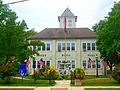
Borough Hall
-
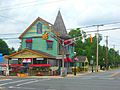
Market on US 40


See also
 In Spanish: Elmer (Nueva Jersey) para niños
