Emmaus, Pennsylvania facts for kids
Quick facts for kids
Borough of Emmaus
|
|
|---|---|
|
Borough
|
|

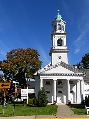
Emmaus Moravian Church in Emmaus, 2012
|
|

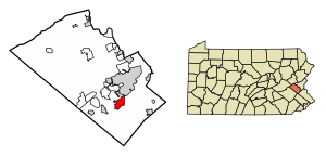
Location of Emmaus in Lehigh County, Pennsylvania.
|
|
| Country | United States |
| State | Pennsylvania |
| County | Lehigh |
| Established | 1759 |
| Area | |
| • Total | 2.90 sq mi (7.51 km2) |
| • Land | 2.90 sq mi (7.50 km2) |
| • Water | 0.00 sq mi (0.01 km2) |
| Elevation | 436 ft (133 m) |
| Population
(2010)
|
|
| • Total | 11,211 |
| • Estimate
(2019)
|
11,467 |
| • Density | 3,960.97/sq mi (1,529.30/km2) |
| Time zone | UTC-5 (EST) |
| • Summer (DST) | UTC-4 (EDT) |
| ZIP codes |
18049, 18098, 18099
|
| Area code(s) | 610 Exchanges: 904,965,966,967 |
| FIPS code | 42-23584 |
Emmaus ( em-AY-əs) is a borough in Lehigh County, Pennsylvania, in the United States. It is part of the Lehigh Valley, which has a population of 861,899 and is the 69th most populated metropolitan area in the U.S. The population of Emmaus was 11,467 as of the 2020 U.S. census.
Emmaus is approximately 5 miles (8.0 km) southwest of Allentown, 53 miles (85 km) north-northwest of Philadelphia, and 92 miles (148 km) west of New York City.
In 2007 and 2009, Emmaus was listed as one of the top 100 "Best Places to Live" in the United States by Money magazine.
Contents
Geography
According to the United States Census Bureau, the borough has a total area of 2.9 square miles (7.5 km2), all land, though parts of the Little Lehigh Creek, a tributary of the Lehigh River, flow just outside the Emmaus border with Salisbury Township. Emmaus borders South Mountain, a large mountain range. The town's elevation is 436 feet above sea level. Emmaus is located at approximately 40°32′13″N 75°29′45″W / 40.53694°N 75.49583°W.
Demographics
| Historical population | |||
|---|---|---|---|
| Census | Pop. | %± | |
| 1860 | 381 | — | |
| 1870 | 477 | 25.2% | |
| 1880 | 847 | 77.6% | |
| 1890 | 883 | 4.3% | |
| 1900 | 1,488 | 68.5% | |
| 1910 | 3,501 | 135.3% | |
| 1920 | 4,370 | 24.8% | |
| 1930 | 6,419 | 46.9% | |
| 1940 | 6,731 | 4.9% | |
| 1950 | 7,780 | 15.6% | |
| 1960 | 10,262 | 31.9% | |
| 1970 | 11,511 | 12.2% | |
| 1980 | 11,001 | −4.4% | |
| 1990 | 11,157 | 1.4% | |
| 2000 | 11,313 | 1.4% | |
| 2010 | 11,211 | −0.9% | |
| 2019 (est.) | 11,467 | 2.3% | |
| Sources: | |||
As of the 2010 U.S. census, there were 11,313 people, 4,985 households, and 3,155 families residing in the borough. The population density was 3,918.8 people per square mile (1,511.4/km2). There were 5,186 housing units at an average density of 1,796.4 per square mile (692.8/km2). The racial makeup of the borough was 95.89% White, 0.70% African American, 0.06% Native American, 1.81% Asian, 0.03% Pacific Islander, 0.88% from other races, and 0.63% from two or more races. Hispanic or Latino of any race were 1.51% of the population.
Of the borough's 4,985 households, 26.4% had children under the age of 18 living with them, 50.9% were married couples living together, 9.1% had a female householder with no husband present, and 36.7% were non-families. 31.5% of all households were made up of individuals, and 13.6% had someone living alone who was 65 years of age or older. The average household size was 2.26 and the average family size was 2.85.
In the borough, the population was spread out, with 21.2% under the age of 18, 6.6% from 18 to 24, 31.0% from 25 to 44, 22.1% from 45 to 64, and 19.1% who were 65 years of age or older. The median age was 40 years. For every 100 females, there are 91.7 males. For every 100 females age 18 and over, there were 88.8 males.
The median income for a household in the borough was $55,139, whereas the estimated median household for the state of Pennsylvania is $52,007, and the median income for a family was $54,120. Males had a median income of $38,659 versus $25,331 for females. The per capita income for the borough was $23,245. About 2.2% of families and 3.5% of the population were below the poverty line, including 1.2% of those under age 18 and 7.9% of those age 65 or over.
History
Founding
Emmaus was settled in the 1740s and dates its founding to 1759. For approximately 100 years, until the mid-19th century, it was a closed community of the Moravian Church. The original land on which the town now lies was donated by Sebastian Heinrich Knauss and Jacob Ehrenhardt for use by the Moravian church. The founders and original residents of the town were members of the Lutheran and Reformed faiths, who joined the Moravian church when their own denominations were unable to provide ministers. Emmaus was one of the four leading Moravian communities in the northeast United States at the time of its founding; Bethlehem, PA, Lititz, PA and Nazareth, PA were the three others.
Origin and spelling of name
The borough was named for the biblical village of Emmaus (now within modern Israel), where, according to the New Testament, Jesus was seen by his disciples Luke and Cleopas following his crucifixion and resurrection.
From its founding in 1759 until 1830, the settlement's name was spelled Emmaus. From 1830 until 1938, however, the community used the Pennsylvania Dutch spelling of the name, Emaus, to reflect local language and the significant presence of Pennsylvania Dutch. In German into the early twentieth century, the name had been spelled with a line above the m, which indicated a doubling of the letter, which had also been the usage in English into the sixteenth century. Since this tradition had died out in English, the line was often omitted in spellings of the name, which became confusing to the now more prevalent English speakers. In 1938, after petitions circulated by the local Rotary Club, the borough formally changed the name's spelling to Emmaus, reflecting the spelling in the Gospel of Luke in the English New Testament.
19th century
Iron ore was discovered nearby in the 19th century and served as a source of industrial growth for much of the 19th and 20th centuries. In 1859, the East Pennsylvania Railroad (later part of the Philadelphia and Reading Railroad) brought trains to Emmaus. That same year, the town was incorporated as a borough. In 1869, the town's first blast furnace opened. The largest iron company was Donaldson Iron Company, which made cast iron pipes and other products until the company closed in 1943. During the 19th century, Emmaus was also a center of silk and cigar manufacturing.
Population trends
In 1940, public census statistics showed that 6,731 people lived in Emmaus. The population of the borough has since nearly doubled to 11,313, as of the 2000 census. Housing construction has reached the borough line in all directions, so significant continued population growth in the borough is unlikely. Outside the borough line, however, the local population continues to grow, particularly in neighboring Lower Macungie Township.
Historic sites
Emmaus is home to several residences and other properties that were constructed in the late 18th and early 19th centuries, and have been labeled historic sites by the Commonwealth of Pennsylvania. Under historical preservation Commonwealth laws, the sites are protected from commercial and other development expansion in the borough.
Departments
Fire Department
Until the 1980s, fire protection operated through three fire companies. In 1980, the Borough completed the construction of the Central Fire Station on 6th street from which all personnel and equipment are currently dispatched. The staff is composed of paid on-call volunteers who respond, on average, 375-400 calls per year. Calls include fire protection, rescue/extrication, and HAZMAT response, and are dispatched via Lehigh County's 911 Communications Center. It's vehicles include two 1988 Central States 1250 GPM Pumpers, One 110' Simon LTI 1989 Aerial, Central States 2002 Heavy Rescue Unit, 1989 Chevrolet Fire Police Vehicle, 1985 Chevrolet and a 1983 Ford Special response units, 1969 Ford bucket utility truck, 2001 GMC Yukon (Fire Chief's vehicle), and a 2011 HME 109' aerial ladder truck.
Police Department
During the late 1800s the Borough of Emmaus provided protection for the community by appointing "High Constables." The Emmaus Police Department was established in 1909 when Wilson Kratzer was appointed as the first Police Chief. Since then, the Emmaus Police Department has grown to be a Pennsylvania Accredited Law Enforcment Agency.
Emmaus Ambulance
Emmaus Ambulance Corps provides ambulance coverage for Emmaus Borough, the eastern portion of Upper Milford Township, and a portion of Western Salisbury Township in Lehigh County, Pennsylvania. The Corps also provides mutual aid response to surrounding areas including: Macungie Borough, Lower Macungie Township, Upper Saucon Township, and the City of Allentown. As of April 1, 2004, the Corps began Advanced Life Support service, allowing the Corps to provide a higher level of patient care via state certified paramedics with advanced cardiac care and trauma care procedures. The number of emergency responses in 2004 was 1301. The 2005 call volume was 1607, and the 2006 call volume was 1604. The Emmaus Ambulance service currently consists 3 ALS equipped ambulances and 1 wheelchair/ambulette transport van.
Transportation
Emmaus is accessible by two Lehigh County highways, Cedar Crest Boulevard, located on the borough's west-side, and Lehigh Street, which is located on the borough's east-side and connects Emmaus with Allentown and Bethlehem. Both highways have junctions with I-78, which spans from Lebanon County in the west to the Holland Tunnel and New York City in the east. Route 29 runs through the west-side of the borough at Cedar Crest Boulevard and Chestnut Street. LANta provides bus service to and from Emmaus on its Route 104 service through Allentown to and from the Lehigh Valley Mall in Whitehall Township.
Education
Emmaus is served educationally by the East Penn School District, a public school district that accommodates kindergarten through 12th grade.
The district operates a high school, Emmaus High School located in Emmaus (for grades nine through 12), two middle schools, Eyer Middle School and Lower Macungie Middle School both located in Macungie (for grades six through eight), seven public elementary schools (Alburtis Elementary School, Jefferson Elementary School, Lincoln Elementary School, Macungie Elementary School, Shoemaker Elementary School, Wescosville Elementary School, and Willow Lane Elementary School), and one public elementary charter school, Seven Generations Charter School.
Notable people
- Charles Bierbauer, former CNN correspondent
- Howard J. Buss, composer and music publisher
- Aaron Gray, former professional basketball player, Chicago Bulls, Detroit Pistons, New Orleans Hornets and Sacramento Kings
- Keith Jarrett, jazz pianist
- Michael Johns, health care executive and former White House presidential speechwriter
- Trina Radke, 1988 U.S. Olympian, U.S. swimming team
- J. I. Rodale, founder of Rodale, Inc.
- Robert Rodale, publisher
- Cindy Werley, 1996 U.S. Olympian, U.S. field hockey team
See also
 In Spanish: Emmaus para niños


