
Environment of Iowa facts for kids


The environment of Iowa has been heavily affected by agricultural production since it became a U.S. state in 1846. However, there remain natural areas in Iowa that reflect a wide varieties of environmental niches.
Contents
Ecology and biota
Iowa's natural vegetation is tallgrass prairie and savanna in upland areas, with dense forest and wetlands in floodplains and protected river valleys, and pothole wetlands in northern prairie areas. Most of Iowa is used for agriculture, crops cover 60% of the state, grasslands (mostly pasture and hay with some prairie and wetland) cover 30%, and forests cover 7%; urban areas and water cover another 1% each.
Presettlement biota

In 1840 Isaac Galland noted a large number of fauna in Iowa, including bison, elk, deer (either white-tailed deer or mule deer), raccoon, fox squirrel, mountain lion, lynx, gray wolf, black wolf, coyote (he called them prairie wolves), bear, beaver, otter, muskrat, mink, rabbits (presumably cottontail rabbit and hare), opossum, skunk, porcupine, groundhog, timber rattlesnake, prairie rattlesnake, bull snake, black snake, water moccasin, garter snake, water snakes, turkey, prairie chicken, quail, swan, geese, brant goose, duck, crane (he called them pelicans), crow, blackbird, bald eagle, "grey eagle" (probably a hawk or falcon), buzzard, raven, mourning dove, passenger pigeon, woodpeckers, woodcocks, hummingbird, and the honeybee. Galland also included a list of edible flora readily available in Iowa, including strawberry, blackberry, raspberry, gooseberry, plum, crabapple, hickory nut, black walnut, butternut, hazelnut, pecan, grape, cherry, black haw, red haw, pawpaw, and cranberry.
The first comprehensive listing of bird species in Iowa was compiled by Charles Rollin Keyes in 1889 which listed 262 species. The first comprehensive listing of mammals in Iowa was made by Herbert Osborne in 1890.
Natural Areas
There is a dearth of natural areas in Iowa; less than 1% of the tallgrass prairie that once covered most of Iowa remain intact, only about 5% of the state's prairie pothole wetlands remain, and most of the original forest has been lost. Iowa ranks 49th of U.S. states in public land holdings.
Threatened and endangered species
As of 2016, the U.S. Fish and Wildlife Service the lists of threatened and endangered species in Iowa have included the following:
Federally endangered animal species:

- Indiana bat (Myotis sodalis)
- Higgins eye pearly mussel (Lampsilis higginsii)
- Topeka shiner (Notropis topeka)
- Iowa Pleistocene snail (Discus macclintocki)
- Pallid sturgeon (Scaphirhynchus albus)
- Least interior tern (Sterna antillarum)
- Sheepnose Mussel (Plethobasus cyphyus)
- Spectaclecase (mussel) (Cumberlandia monodonta)
- Poweshiek Skipperling, (Oarisma poweshiek)
(3 more since 2010}
Federally threatened animal species:
- Piping plover (Charadrius melodus), except Great Lakes watershed
- Northern long-eared bat (Myotis septentrionalis)
- Skipper, Dakota (Hesperia dacotae)
Extirpated federally endangered animal species:

Locally extinguished animals are:
- American burying beetle (Nicrophorus americanus)
- Winged mapleleaf mussel (Quadrula fragosa)
- Scaleshell mussel (Leptodea leptodon)
- Orange-footed pimpleback mussel (Plethobasus cooperianus)
- Fat pocketbook pearly mussel (Potamilus capax)
- Gray wolf (Canis lupus)* Gray western Great Lakes wolf (Canis lupus)
- Bat, Indiana Entire (Myotis sodalis)
-* Note: Wolves occasionally reappear in Iowa, roaming south from home ranges in Minnesota and Wisconsin.
Federally threatened plant species:

- Prairie bush-clover (Lespedeza leptostachya)
- Mead's milkweed (Asclepias meadii)
- Northern wild monkshood (Aconitum noveboracense)
- Eastern prairie fringed orchid (Platanthera leucophaea)
- Western prairie fringed orchid (Platanthera praeclara)
Extinct animal species (historical):

- Carolina parakeet (Conuropsis carolinensis)
- Passenger pigeon (Ectopistes migratorius)
Landforms and topography
Despite popular perception, Iowa is generally not flat; most of the state consists of rolling hills. Prior divides Iowa into eight landforms based on glaciation, soils, topography, and river drainage:
- The Paleozoic plateau, also known as the Driftless Area, is a region of scenic, high relief landscapes includes such features as resistant, bluff-forming bedrock outcrops, deep V-shaped valleys, caves, springs, and sinkholes. Glacial deposits and loess are thin or absent over most of the region.
- The Des Moines lobe, a remnant of the extensive prairie wetlands that once covered the Des Moines Lobe. Often called the Prairie Pothole Region, the Des Moines Lobe was glaciated up until 12,000 years ago during the Wisconsin glaciation. The area is marked by rolling terrain and ridges. Historically, this area was peppered with small interconnected swamps, most of which were drained for farmland. The Iowa Great Lakes occur along the western edge of the Des Moines lobe.
- The southern Iowa drift plain covers most of the southern half of Iowa. This is probably the most familiar landscape to travelers, since most of Interstate 80 in Iowa runs through the SIDP. The classic Iowa landscape, consisting of rolling hills of Wisconsin-age loess on Illinoian (or earlier) till. The SIDP is some of the most productive agricultural land in the world.
- The Mississippi alluvial plain includes generally level areas of stream terraces, paleochannels, backwater sloughs, and oxbow lakes within the broad Mississippi River valley.
- The Loess Hills consist of very thick deposits of loess in far western Iowa deposited during the Wisconsin and Illinoian periods. Highly eroded, leaving stark, beautiful "golden hills.
- The Iowan surface in northeast Iowa is covered with eroded Illinoian till with moderate loess formation, frequently in the form of paha ridges, muted relief except for steep rolling hills near river valleys, and deeper valleys. These picturesque hills are depicted in many of the landscapes of Grant Wood.
- The northwest Iowa plains are rolling hills consisting of eroded soils developed since pre-Wisconsinan glaciation, but with significant amounts of loess.
- The Missouri alluvial plain is perhaps the only truly flat region of Iowa, the Missouri Alluvial Plain contains areas of terraces, sloughs, and oxbows. Its valley trench is not as deep as the Mississippi River system, and the Missouri River is contained in a much narrower channel. In Iowa, the eastern border of the Missouri Plains is the Loess Hills, forming steep rounded bluffs.
Gallery of Iowa landforms
-
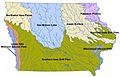
Landforms of Iowa, based on Prior (1991)
-
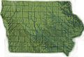
Topography of Iowa, with counties and major streams
-
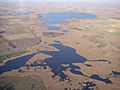
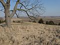
Barringer Slough, part of the Des Moines lobe
-
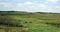
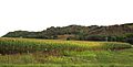
Typical view of the Southern Iowa Drift Plain
-
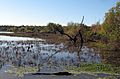
Mississippi valley wetland near Ft. Madison
-
Loess Hills east of Mondamin, Iowa, showing the transition with the Missouri alluvial plain.
-
Mississippi River alluvial plain from SIDP bluffs north of Kingston.


Water

As in most of the U.S., surface water in Iowa is not safe to drink untreated, contamination by agricultural runoff including nitrates, herbicides, pesticides, and animal waste is common. Municipal water supplies are typically heavily chlorinated, this chlorine, combined with high nitrate levels, often give municipal water a strong smell, and the limestone bedrock in much of the state causes hard water.
Some communities, such as Iowa City resort to additional carbon filtration and lime softening coagulation-sedimentation to make the water more palatable. Water treatment is effective but comes at a price; while the Des Moines' advanced filtration system has led to water quality ranked among the nation's best. In January 2015, the Des Moines Water Works "sued drainage districts in three northern Iowa counties, claiming the tiles there act as a conduit that accelerates the movement of fertilizer from farm fields into Iowa waterways". Between 2010 and 2015 more than 60 Iowa cities and towns had high nitrate levels in drinking water.
In 2015, there were a record number of beach closures because of harmful algal bloom in Iowa.
Floods

Major flood events occurred in Iowa in 1851, 1892, 1965, 1993, 2008. The Great flood of 1851 hit all of Iowa, and almost destroyed the nascent town of Des Moines. "The Des Moines and Raccoon rivers rose to an unprecedented height, inundating the entire country east of the Des Moines river. Crops were utterly destroyed, houses and fences swept away." After the town of Dudley was destroyed, survivors moved to higher ground and founded Carlisle. The flood of 1851 produced record levels on the Iowa River at Iowa City and the Cedar River at Cedar Rapids that stood until the Iowa flood of 2008. The flash flood of 1892 destroyed much of Sioux City. The Flood of 1965 affected eastern Iowa, from Cedar Rapids to Dubuque, with cities along the Mississippi hardest hit. The 1993 floods were widespread across the upper Midwest, causing extensive damage to Coralville and Iowa City.
Soils
The Natural Resources Conservation Service divides Iowa into 23 soil regions. In general, soils of southern, eastern, and western Iowa are loess-derived, while soils of northern and central Iowa are till-derived. Most level areas of Iowa have soils highly suitable for agriculture, making Iowa one of the most productive farming regions of the world.
Climate statistics for selected cities
| Climate data for Des Moines International Airport, Iowa (1981–2010 normals, extremes 1878–present ) | |||||||||||||
|---|---|---|---|---|---|---|---|---|---|---|---|---|---|
| Month | Jan | Feb | Mar | Apr | May | Jun | Jul | Aug | Sep | Oct | Nov | Dec | Year |
| Record high °F (°C) | 67 (19) |
78 (26) |
91 (33) |
93 (34) |
105 (41) |
103 (39) |
110 (43) |
110 (43) |
101 (38) |
95 (35) |
82 (28) |
69 (21) |
110 (43) |
| Mean maximum °F (°C) | 53.1 (11.7) |
59.1 (15.1) |
75.0 (23.9) |
84.0 (28.9) |
87.6 (30.9) |
93.2 (34.0) |
96.3 (35.7) |
95.2 (35.1) |
90.4 (32.4) |
82.4 (28.0) |
69.1 (20.6) |
55.8 (13.2) |
97.8 (36.6) |
| Average high °F (°C) | 31.0 (−0.6) |
36.1 (2.3) |
49.0 (9.4) |
62.3 (16.8) |
72.4 (22.4) |
81.6 (27.6) |
85.7 (29.8) |
83.8 (28.8) |
76.1 (24.5) |
63.1 (17.3) |
47.9 (8.8) |
34.0 (1.1) |
60.4 (15.8) |
| Average low °F (°C) | 14.3 (−9.8) |
18.8 (−7.3) |
29.7 (−1.3) |
41.1 (5.1) |
52.2 (11.2) |
62.0 (16.7) |
66.8 (19.3) |
64.8 (18.2) |
55.2 (12.9) |
43.0 (6.1) |
30.5 (−0.8) |
18.0 (−7.8) |
41.5 (5.3) |
| Mean minimum °F (°C) | −7.8 (−22.1) |
−4.1 (−20.1) |
9.5 (−12.5) |
23.7 (−4.6) |
37.6 (3.1) |
49.1 (9.5) |
56.3 (13.5) |
53.5 (11.9) |
38.0 (3.3) |
26.2 (−3.2) |
12.4 (−10.9) |
−3.6 (−19.8) |
−12.8 (−24.9) |
| Record low °F (°C) | −30 (−34) |
−26 (−32) |
−22 (−30) |
9 (−13) |
26 (−3) |
37 (3) |
47 (8) |
40 (4) |
26 (−3) |
7 (−14) |
−10 (−23) |
−22 (−30) |
−30 (−34) |
| Average precipitation inches (mm) | 1.00 (25) |
1.28 (33) |
2.30 (58) |
3.86 (98) |
4.74 (120) |
4.94 (125) |
4.47 (114) |
4.13 (105) |
3.05 (77) |
2.64 (67) |
2.19 (56) |
1.42 (36) |
36.02 (915) |
| Average snowfall inches (cm) | 8.5 (22) |
7.9 (20) |
5.2 (13) |
1.8 (4.6) |
0 (0) |
0 (0) |
0 (0) |
0 (0) |
0 (0) |
0.4 (1.0) |
2.5 (6.4) |
9.0 (23) |
35.3 (90) |
| Average precipitation days (≥ 0.01 in) | 7.5 | 7.8 | 9.7 | 11.2 | 12.5 | 11.5 | 10.1 | 9.1 | 8.4 | 8.9 | 8.3 | 8.4 | 113.4 |
| Average snowy days (≥ 0.1 in) | 6.5 | 5.6 | 3.2 | 1.0 | 0 | 0 | 0 | 0 | 0 | 0.3 | 2.0 | 6.2 | 24.8 |
| Average relative humidity (%) | 71.0 | 71.3 | 67.9 | 63.2 | 63.0 | 64.8 | 67.7 | 70.0 | 70.9 | 66.5 | 71.0 | 74.6 | 68.5 |
| Mean monthly sunshine hours | 157.7 | 163.3 | 206.0 | 222.2 | 276.0 | 312.1 | 337.8 | 297.9 | 239.8 | 210.0 | 138.5 | 129.2 | 2,690.5 |
| Percent possible sunshine | 53 | 55 | 56 | 56 | 61 | 69 | 73 | 70 | 64 | 61 | 47 | 45 | 60 |
| Source: NOAA (relative humidity and sun 1961−1990) | |||||||||||||
| Climate data for Quad Cities (Quad City International Airport), 1981–2010 normals, extremes 1871–present | |||||||||||||
|---|---|---|---|---|---|---|---|---|---|---|---|---|---|
| Month | Jan | Feb | Mar | Apr | May | Jun | Jul | Aug | Sep | Oct | Nov | Dec | Year |
| Record high °F (°C) | 69 (21) |
74 (23) |
88 (31) |
93 (34) |
104 (40) |
104 (40) |
111 (44) |
106 (41) |
100 (38) |
95 (35) |
80 (27) |
71 (22) |
111 (44) |
| Average high °F (°C) | 31.0 (−0.6) |
35.7 (2.1) |
48.8 (9.3) |
62.3 (16.8) |
72.9 (22.7) |
82.3 (27.9) |
85.8 (29.9) |
83.8 (28.8) |
76.8 (24.9) |
64.1 (17.8) |
49.2 (9.6) |
34.6 (1.4) |
60.6 (15.9) |
| Average low °F (°C) | 14.3 (−9.8) |
18.3 (−7.6) |
29.4 (−1.4) |
40.5 (4.7) |
50.7 (10.4) |
60.7 (15.9) |
65.0 (18.3) |
63.2 (17.3) |
53.9 (12.2) |
42.4 (5.8) |
30.9 (−0.6) |
18.6 (−7.4) |
40.7 (4.8) |
| Record low °F (°C) | −27 (−33) |
−28 (−33) |
−19 (−28) |
7 (−14) |
25 (−4) |
39 (4) |
46 (8) |
40 (4) |
24 (−4) |
11 (−12) |
−10 (−23) |
−24 (−31) |
−28 (−33) |
| Average precipitation inches (mm) | 1.49 (38) |
1.60 (41) |
2.86 (73) |
3.59 (91) |
4.32 (110) |
4.49 (114) |
4.29 (109) |
4.52 (115) |
3.09 (78) |
2.97 (75) |
2.56 (65) |
2.18 (55) |
37.96 (964) |
| Average snowfall inches (cm) | 9.4 (24) |
6.8 (17) |
4.0 (10) |
0.9 (2.3) |
0 (0) |
0 (0) |
0 (0) |
0 (0) |
0 (0) |
0 (0) |
1.2 (3.0) |
9.3 (24) |
31.6 (80) |
| Average precipitation days (≥ 0.01 in) | 8.8 | 8.3 | 10.1 | 11.0 | 11.7 | 10.5 | 9.8 | 9.8 | 8.2 | 9.1 | 9.8 | 10.0 | 117.1 |
| Average snowy days (≥ 0.1 in) | 7.1 | 5.6 | 3.2 | 0.7 | 0 | 0 | 0 | 0 | 0 | 0 | 1.7 | 6.8 | 25.1 |
| Average relative humidity (%) | 69.9 | 69.8 | 68.3 | 64.3 | 64.9 | 65.8 | 70.5 | 73.3 | 72.8 | 68.1 | 71.3 | 74.0 | 69.4 |
| Mean monthly sunshine hours | 148.1 | 153.8 | 180.5 | 210.1 | 255.1 | 284.6 | 301.9 | 271.4 | 222.0 | 192.9 | 121.7 | 113.9 | 2,456 |
| Percent possible sunshine | 50 | 52 | 49 | 53 | 57 | 63 | 66 | 63 | 59 | 56 | 41 | 40 | 55 |
| Source: NOAA (relative humidity and sun 1961−1990) | |||||||||||||
| Climate data for Sioux City, Iowa (Sioux Gateway Airport), 1981–2010 normals, extremes 1889–present | |||||||||||||
|---|---|---|---|---|---|---|---|---|---|---|---|---|---|
| Month | Jan | Feb | Mar | Apr | May | Jun | Jul | Aug | Sep | Oct | Nov | Dec | Year |
| Record high °F (°C) | 71 (22) |
75 (24) |
91 (33) |
98 (37) |
106 (41) |
108 (42) |
111 (44) |
108 (42) |
103 (39) |
96 (36) |
82 (28) |
71 (22) |
111 (44) |
| Average high °F (°C) | 30.5 (−0.8) |
34.9 (1.6) |
47.5 (8.6) |
62.3 (16.8) |
73.0 (22.8) |
82.1 (27.8) |
85.5 (29.7) |
83.3 (28.5) |
76.2 (24.6) |
63.3 (17.4) |
46.4 (8.0) |
32.1 (0.1) |
59.8 (15.4) |
| Average low °F (°C) | 10.2 (−12.1) |
15.2 (−9.3) |
25.5 (−3.6) |
36.8 (2.7) |
48.7 (9.3) |
58.6 (14.8) |
63.2 (17.3) |
60.9 (16.1) |
50.6 (10.3) |
38.0 (3.3) |
25.2 (−3.8) |
13.0 (−10.6) |
37.2 (2.9) |
| Record low °F (°C) | −35 (−37) |
−31 (−35) |
−22 (−30) |
−2 (−19) |
23 (−5) |
38 (3) |
41 (5) |
37 (3) |
24 (−4) |
5 (−15) |
−9 (−23) |
−28 (−33) |
−35 (−37) |
| Average precipitation inches (mm) | 0.62 (16) |
0.67 (17) |
2.00 (51) |
2.95 (75) |
3.74 (95) |
3.89 (99) |
3.44 (87) |
3.23 (82) |
2.96 (75) |
2.13 (54) |
1.31 (33) |
0.80 (20) |
27.74 (705) |
| Average snowfall inches (cm) | 6.7 (17) |
6.6 (17) |
6.5 (17) |
1.8 (4.6) |
0 (0) |
0 (0) |
0 (0) |
0 (0) |
0 (0) |
1.0 (2.5) |
4.4 (11) |
7.8 (20) |
34.8 (88) |
| Average precipitation days (≥ 0.01 in) | 6.3 | 6.0 | 8.3 | 9.9 | 11.3 | 10.9 | 9.5 | 9.4 | 8.3 | 7.4 | 6.7 | 6.9 | 100.9 |
| Average snowy days (≥ 0.1 in) | 5.9 | 5.0 | 3.8 | 1.4 | 0 | 0 | 0 | 0 | 0 | 0.5 | 3.2 | 5.7 | 25.5 |
| Average relative humidity (%) | 72.2 | 72.4 | 69.7 | 61.6 | 62.3 | 65.5 | 69.2 | 72.0 | 70.8 | 66.2 | 72.3 | 75.9 | 69.2 |
| Mean monthly sunshine hours | 171.1 | 165.5 | 211.9 | 232.3 | 271.8 | 310.2 | 330.9 | 292.9 | 235.5 | 209.3 | 146.4 | 138.3 | 2,716.1 |
| Percent possible sunshine | 58 | 56 | 57 | 58 | 60 | 68 | 71 | 68 | 63 | 61 | 50 | 49 | 61 |
| Source: NOAA (relative humidity and sun 1961–1990) , The Weather Channel | |||||||||||||
- Iowa Department of Natural Resources, http://www.iowadnr.gov/
- Iowa Natural Resources Conservation Services, http://www.ia.nrcs.usda.gov/
- Nature Conservancy Iowa, http://www.nature.org/wherewework/northamerica/states/iowa/news/campaign.html
- Iowa Geological Survey, http://www.igsb.uiowa.edu/
- Iowa Geographical Map Server, http://cairo.gis.iastate.edu/
- U.S. Geological Survey Iowa Overview, http://www.usgs.gov/state/state.asp?State=IA
- Geological Society of Iowa, http://www.iowageology.org/
Images for kids
-
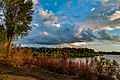
Lake near Cedar Rapids
-

View from Balltown
-
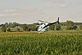
Helicopter over an Iowan cornfield
-
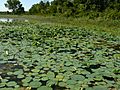
DeSoto National Wildlife Refuge
.jpg)


