
Eritrea facts for kids
Quick facts for kids
State of Eritrea
ሃገረ ኤርትራ Hagere Ertra
دولة إرتريا Dawlat Iritriyā |
|
|---|---|
|
Anthem: Ertra, Ertra, Ertra
Eritrea, Eritrea, Eritrea |
|
.svg) |
|
| Capital and largest city
|
Asmara |
| Official languages | Tigrinya Arabic English |
| Ethnic groups
(2012)
|
55% Tigrinya 30% Tigre 4% Saho 2% Kunama 2% Rashaida 2% Bilen 5% othera |
| Demonym(s) | Eritrean |
| Government | Unitary Single-party under an totalitarian dictatorship |
|
• President
|
Isaias Afewerki |
| Independence | |
|
• From Italy
|
November 1941 |
|
• From United Kingdom under UN Mandate
|
1951 |
| 24 May 1991 | |
| 24 May 1993 | |
| Area | |
|
• Total
|
117,600 km2 (45,400 sq mi) (101st) |
|
• Water (%)
|
0.14% |
| Population | |
|
• 2012 estimate
|
6,086,495 (107th) |
|
• 2008 census
|
5,291,370 |
|
• Density
|
51.8/km2 (134.2/sq mi) (154th) |
| GDP (PPP) | 2012 estimate |
|
• Total
|
$4.397 billion |
|
• Per capita
|
$777 |
| GDP (nominal) | 2012 estimate |
|
• Total
|
$3.108 billion |
|
• Per capita
|
$549 |
| HDI (2011) | low · 177th |
| Currency | Nakfa (ERN) |
| Time zone | UTC+3 (EAT) |
|
• Summer (DST)
|
UTC+3 (not observed) |
| Driving side | right |
| Calling code | 291 |
| ISO 3166 code | ER |
| Internet TLD | .er |
|
|

.svg)

Eritrea is a country on the eastern coast of Africa. Its official name is The State of Eritrea.
Geography

Eritrea is located on the coast on the Red Sea. It is north of the Bab-el-Mandeb and the Horn of Africa. Eritrea has borders with the countries of Sudan, Ethiopia, and Djibouti. The land area of Eritrea is 101,000 km², and it is one of the smallest countries in Africa.
History
.jpg)
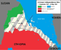
Eritrea became an independent country on 24 May 1993. It is one of the newest countries in the world.
Many different countries have ruled the land that is now called Eritrea. Between 1885 and 1941 it was a colony of Italy. Between 1941 and 1952, the United Nations put it under the protection of United Kingdom. After 1952, Eritrea became a part of Ethiopia. This was the reason for a long civil war between the Eritreans and the government of Ethiopia.
Eventually, in 1993, Eritrea became an independent country after a vote by its people.
Administrative divisions
Eritrea is divided into six administrative regions. These areas are then divided into 58 districts.

| Region | Area (km2) | Population | Capital |
|---|---|---|---|
| Central | 1,300 | 1,053,254 | Asmara |
| Anseba | 23,200 | 893,587 | Keren |
| Gash-Barka | 33,200 | 1,103,742 | Barentu |
| Southern | 8,000 | 1,476,765 | Mendefera |
| Northern Red Sea | 27,800 | 897,454 | Massawa |
| Southern Red Sea | 27,600 | 398,073 | Assab |
Culture
The population of Eritrea is about 5.6 million. About 0.5 million people live in Asmara. People from Eritrea are called Eritreans. Most of them speak Tigrinya or Tigre as their first language. The people usually use Tigrinya or Arabic for official business.
Eritrea has nine ethnic groups. These are the Afar people, the Bilen people, the Hedareb people, the Kunama, the Nara, the Rashaida, the Saho, the Tigre, and Tigray-Tigrinya.
The currency of Eritrea is called the Nakfa. Eritrea is a very poor country. Almost half of Eritrea's economy comes from Eritreans who live abroad. They send money home to their families. Most of the rest comes from farming.
Football and cycling are the most popular sports in Eritrea. In recent years, Eritrean athletes have also seen increasing success in the international arena.
Related pages
Images for kids
-
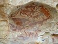
Deka Rock Art in Deka Arbaa, Debub region of Eritrea dated to 100,000 years ago
-
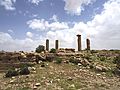
Pre-Axumite monolithic columns in Qohaito
-
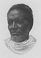
Bahta Hagos was an important leader of the Eritrean resistance to foreign domination, specifically against northern Ethiopian and Italian colonialism.
-
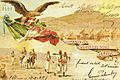
Postcard of the Carabinieri sent from Italian Eritrea in 1907
-
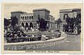
Piazza Roma in Italian Asmara
-
Eritrean War of Independence against Ethiopia 1961–1991
-
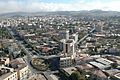
A view over Asmara
-
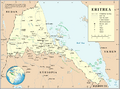
Map of Eritrea
-
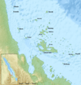
The Dahlak Archipelago
-
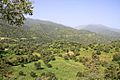
Eritrean landscape near road to Massawa
-
The 23d ISCOE East Africa Conference in Asmara in 2019
-
Independence Day is one of the most important public holidays in Eritrea.
-
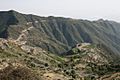
Eritrean mountain road
-
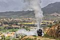
Steam train outside Asmara on the Eritrean Railway
-
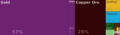
Eritrea's main exports, 2013
-
A woman and a man in Barentu wearing traditional clothes
-
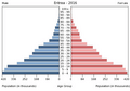
Population pyramid of Eritrea 2016
-
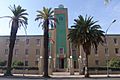
Building of regional administration in Asmara
-
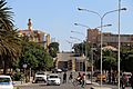
Asmara, Eritrea in 2015
-
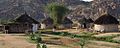
Traditional Eritrean agudo/tukul huts in a village near Barentu
-
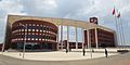
The Eritrea Institute of Technology
-
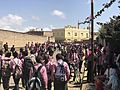
Eritrean pupils in uniform
-
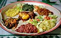
Eritrean injera with various stews
-

Eritrean artist Helen Meles
-
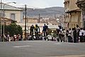
Tour of Eritrea cycling competition in Asmara, Eritrea.
-
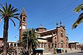
Church of Our Lady of the Rosary in the capital Asmara

.jpg)

.jpg)


See also
 In Spanish: Eritrea para niños
