
Esmeralda County, Nevada facts for kids
Quick facts for kids
Esmeralda County
|
||
|---|---|---|
| Esmeralda County | ||

Esmeralda County Courthouse in Goldfield
|
||
|
||

Location within the U.S. state of Nevada
|
||
 Nevada's location within the U.S. |
||
| Country | ||
| State | ||
| Founded | November 25, 1861 | |
| Named for | Emerald | |
| Seat | Goldfield | |
| Largest community | Dyer | |
| Area | ||
| • Total | 3,589 sq mi (9,300 km2) | |
| • Land | 3,582 sq mi (9,280 km2) | |
| • Water | 7.2 sq mi (19 km2) 0.2% | |
| Population
(2020)
|
||
| • Total | 729 | |
| • Density | 0.20312/sq mi (0.07843/km2) | |
| Time zone | UTC−8 (Pacific) | |
| • Summer (DST) | UTC−7 (PDT) | |
| Congressional district | 4th | |


Esmeralda County is a county in the southwestern portion of the U.S. state of Nevada. As of the 2020 census, the population was 729, making it the least populous county in Nevada. Esmeralda County does not have any incorporated communities. Its county seat is the town of Goldfield.
Its 2000 census population density of 0.2706 inhabitants per square mile (0.1045/km2) was the second-lowest of any county in the contiguous United States (above Loving County, Texas). Its school district does not have a high school, so students in grades 9–12 go to school in Tonopah, in the Nye County School District.
Most residents live in Goldfield or in the Fish Lake Valley, near the California border. Esmeralda is the only Nevada county in the Los Angeles TV market (or any California market) as defined by The Nielsen Corporation.
Contents
History
Esmeralda County is one of the original counties in Nevada, established in 1861. When it was organized, it comprised the part of the Nevada Territory south of the 39th parallel and east of Mason Valley. Esmeralda is the Spanish and Portuguese word for "emerald". An early California miner from San Jose Ca (descended from the Cory family of New Jersey), James Manning Cory, named the Esmeralda Mining District after the Gypsy dancer, Esmeralda, from Victor Hugo's novel, The Hunchback of Notre Dame.
Just after the organization of Esmeralda County, the vast majority of it wasn't discovered yet. John C. Frémont was one of the few people who had discovered parts of the county. He had crossed Big Smoky Valley in 1845. Also, Aurora and its northern corridor had been discovered. In 1862 and 1863, the area along the Reese River was discovered during the Reese River excitement. The event resulted in the establishment of three mining districts in the Toiyabe Range, namely Marysville, Twin River, and Washington, and the establishment of a number of settlements and ranches in Esmeralda County. Explorers kept going south and explored the Shoshone Mountains. The mining district Union was organized after silver was found in 1863 and the settlement of Ione was founded over there.
The total area of Esmeralda County more than halved as Nye County was organized on February 16, 1864. That county was entirely created out of land that used to be part of Esmeralda County. Esmeralda has had three county seats: Aurora until 1883, Hawthorne from 1883 to 1907 and finally Goldfield. At one point, due to the disputed border with California, Aurora was simultaneously the county seat of both Mono County, California and Esmeralda County, Nevada. Samuel Clemens (Mark Twain) wrote about his time as a miner in the Esmeralda District in his book Roughing It.
Esmeralda grew from a gold mining boom in the first years of the 20th century. The mines were largely tapped out by the end of the 1910s and the economy and population declined afterwards.
Geography
According to the U.S. Census Bureau, the county has a total area of 3,589 square miles (9,300 km2), of which 3,582 square miles (9,280 km2) is land and 7.2 square miles (19 km2) (0.2%) is water. It is the fourth-smallest county in Nevada by area. A very small part of Death Valley National Park lies in its southeast corner.
The county is dominated by the Silver Peak and Monte Cristo mountain ranges. Mountains in the county include:
- Boundary Peak, 13,147 feet (4,007 m), the highest natural point in Nevada
- Piper Peak, 9450 feet (2,880 m), the most prominent peak in Esmeralda County
- Magruder Mountain 9044 feet (2,756 m)
- Montezuma Peak, 8373 feet (2,552 m)
- Emigrant Peak, 6790 feet (2,069 m)
Major highways
 Interstate 11 (Future)
 U.S. Route 6
 U.S. Route 95
 State Route 264
 State Route 266
 State Route 773
Adjacent counties

- Mineral County - northwest
- Nye County - east
- Inyo County, California - south
- Mono County, California - west
National protected areas
- Death Valley National Park (part)
- Inyo National Forest (part)
Demographics
| Historical population | |||
|---|---|---|---|
| Census | Pop. | %± | |
| 1870 | 1,553 | — | |
| 1880 | 3,220 | 107.3% | |
| 1890 | 2,148 | −33.3% | |
| 1900 | 1,972 | −8.2% | |
| 1910 | 9,369 | 375.1% | |
| 1920 | 2,410 | −74.3% | |
| 1930 | 1,077 | −55.3% | |
| 1940 | 1,554 | 44.3% | |
| 1950 | 614 | −60.5% | |
| 1960 | 619 | 0.8% | |
| 1970 | 629 | 1.6% | |
| 1980 | 777 | 23.5% | |
| 1990 | 1,344 | 73.0% | |
| 2000 | 971 | −27.8% | |
| 2010 | 783 | −19.4% | |
| 2020 | 729 | −6.9% | |
| U.S. Decennial Census 1790-1960 1900-1990 1990-2000 2010-2020 |
|||
2010 census
At the 2010 census, there were 783 people, 389 households, and 213 families living in the county. The population density was 0.2 inhabitants per square mile (0.077/km2). There were 850 housing units at an average density of 0.2 per square mile (0.077/km2). The racial makeup of the county was 84.4% white, 4.2% American Indian, 0.4% Asian, 6.6% from other races, and 4.3% from two or more races. Those of Hispanic or Latino origin made up 15.3% of the population. In terms of ancestry, 26.7% were German, 18.6% were English, 14.0% were American, 13.8% were Irish, and 8.7% were Swedish.
.jpg)
Of the 389 households, 18.3% had children under the age of 18 living with them, 43.4% were married couples living together, 5.9% had a female householder with no husband present, 45.2% were non-families, and 40.6% of households were made up of individuals. The average household size was 2.01 and the average family size was 2.67. The median age was 52.9 years.
The median household income was $39,712 and the median family income was $57,292. Males had a median income of $41,023 versus $27,019 for females. The per capita income for the county was $34,571. About 6.7% of families and 11.2% of the population were below the poverty line, including 9.8% of those under age 18 and 9.4% of those age 65 or over.
Communities

Unincorporated communities
Each of these communities is a census-designated place:
- Dyer
- Goldfield (county seat)
- Silver Peak
Ghost towns
Education
The Esmeralda County School District has three elementary schools that currently serve approximately 90 students.
Images for kids
-
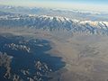
Aerial view of Fish Lake Valley, Nevada-California Border. View is generally to the northeast, towards the Silver Peak Range.
.jpg)
See also
 In Spanish: Condado de Esmeralda para niños
