
Fair Bluff, North Carolina facts for kids
Quick facts for kids
Fair Bluff, North Carolina
|
|
|---|---|

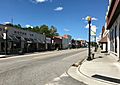
Downtown Fair Bluff
|
|

Fair Bluff, North Carolina
Location in North Carolina
|
|
| Country | United States |
| State | North Carolina |
| County | Columbus |
| Area | |
| • Total | 2.35 sq mi (6.08 km2) |
| • Land | 2.35 sq mi (6.08 km2) |
| • Water | 0.00 sq mi (0.00 km2) |
| Elevation | 66 ft (20 m) |
| Population
(2010)
|
|
| • Total | 951 |
| • Estimate
(2019)
|
881 |
| • Density | 375.37/sq mi (144.93/km2) |
| Time zone | UTC-5 (Eastern (EST)) |
| • Summer (DST) | UTC-4 (EDT) |
| ZIP code |
28439
|
| Area code(s) | 910 |
| FIPS code | 37-22240 |
| GNIS feature ID | 1020187 |
| Website | Official Fair Bluff, NC website: http://www.fairbluff.com/ |
Fair Bluff is a town in Columbus County, North Carolina, United States that was devastated by coastal flooding from Hurricane Matthew in 2016 and inundated again by high water by Hurricane Florence in 2018.
Before the two events, the population was 951 at the 2010 census but is believed to be lower following the two disasters, some estimates going as low as 450 people. The shrinking of town's size, and damage from the storms has led too a rapid decline in tax base, and subsequent -- a migration attributed to climate change.
Contents
History
The Powell House was listed on the National Register of Historic Places in 1978.
Geography
Fair Bluff is located at 34°18′40″N 79°1′57″W / 34.31111°N 79.03250°W (34.311212, -79.032387), along the banks of the Lumber River. It is one of the oldest towns in Columbus County, appearing on maps from the early 19th century, and was once a center of timber production.
According to the United States Census Bureau, the town has a total area of 2.2 square miles (5.7 km2), all of it land.
Demographics
| Historical population | |||
|---|---|---|---|
| Census | Pop. | %± | |
| 1880 | 218 | — | |
| 1890 | 243 | 11.5% | |
| 1900 | 328 | 35.0% | |
| 1910 | 441 | 34.5% | |
| 1920 | 397 | −10.0% | |
| 1930 | 806 | 103.0% | |
| 1940 | 970 | 20.3% | |
| 1950 | 1,056 | 8.9% | |
| 1960 | 1,030 | −2.5% | |
| 1970 | 1,039 | 0.9% | |
| 1980 | 1,095 | 5.4% | |
| 1990 | 1,068 | −2.5% | |
| 2000 | 1,181 | 10.6% | |
| 2010 | 951 | −19.5% | |
| 2019 (est.) | 881 | −7.4% | |
| U.S. Decennial Census | |||
As of the census of 2000, there were 1,181 people, 505 households, and 308 families residing in the town. The population density was 547.4 people per square mile (211.1/km2). There were 588 housing units at an average density of 272.6 per square mile (105.1/km2). The racial makeup of the town was 59.27% African American, 37.93% White, 0.68% Native American, 1.19% from other races, and 0.93% from two or more races. Hispanic or Latino of any race were 1.44% of the population.
There were 505 households, out of which 26.7% had children under the age of 18 living with them, 37.2% were married couples living together, 20.8% had a female householder with no husband present, and 39.0% were non-families. 36.0% of all households were made up of individuals, and 19.8% had someone living alone who was 65 years of age or older. The average household size was 2.32 and the average family size was 2.98.
In the town, the population was spread out, with 25.2% under the age of 18, 7.6% from 18 to 24, 24.1% from 25 to 44, 23.6% from 45 to 64, and 19.4% who were 65 years of age or older. The median age was 39 years. For every 100 females, there were 77.3 males. For every 100 females age 18 and over, there were 72.5 males.
The median income for a household in the town was $17,008, and the median income for a family was $22,969. Males had a median income of $20,764 versus $16,731 for females. The per capita income for the town was $9,829. About 31.8% of families and 37.1% of the population were below the poverty line, including 50.9% of those under age 18 and 24.3% of those age 65 or over.
Images for kids
-
Fair Bluff downtown, largely deserted in 2020

See also
 In Spanish: Fair Bluff (Carolina del Norte) para niños
