Auke Bay, Juneau facts for kids
Quick facts for kids
Auke Bay
Auke Bay
|
|
|---|---|
|
Neighborhood
|
|

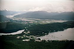
Aerial view shows Auke Bay (including the harbor and Auke Lake) in the foreground. The Mendenhall Peninsula extends to the right behind the community. The lower Mendenhall Valley, Juneau International Airport and Douglas Island are in the background.
|
|
| Country | United States |
| State | Alaska |
| Borough | City and Borough of Juneau |
| Elevation | 10 ft (3 m) |
| Time zone | UTC-9 (Alaska (AKST)) |
| • Summer (DST) | UTC-8 (AKDT) |
| ZIP code |
99801
|
| Area code | 907 |
| FIPS code | 02-04760 |
| GNIS feature ID | 1398469 |
Auke Bay is a neighborhood located in the city and borough of Juneau, Alaska, that contains Auke Bay Harbor, Auke Lake, the University of Alaska Southeast, an elementary school, a church, a post office, a bar, a coffee shop, a waffle house, a thrift shop, a Thai restaurant, and one convenience store. The view of the Mendenhall Glacier behind Auke Bay and Mount McGinnis towering over Auke Lake are some of the most popular photo opportunities in Juneau. The ferry terminal of the Alaska Marine Highway system is also located further out the road in Auke Bay at about 14 miles. The flamingo house on Auke Lake is a local attraction, known for its topical or weather-related formations of pink lawn flamingos. Whale watchings targeting curious humpbacks are available. Humpbacks in these areas are known to demonstrate special feeding methods, so-called "bubble-net feeding", and come very close to shores.
The Coast Guard cutter Liberty is homeported at the Auke Bay Harbor.
Auke Bay takes its name from the native Auke people, a part of the Tlingit tribe.
Climate
Auke Bay has a warm-summer humid continental climate (Köppen Dfb)
| Climate data for Auke Bay | |||||||||||||
|---|---|---|---|---|---|---|---|---|---|---|---|---|---|
| Month | Jan | Feb | Mar | Apr | May | Jun | Jul | Aug | Sep | Oct | Nov | Dec | Year |
| Record high °F (°C) | 58 (14) |
58 (14) |
58 (14) |
71 (22) |
79 (26) |
85 (29) |
89 (32) |
83 (28) |
73 (23) |
63 (17) |
54 (12) |
51 (11) |
89 (32) |
| Average high °F (°C) | 30.5 (−0.8) |
35.5 (1.9) |
40.1 (4.5) |
49.1 (9.5) |
57.1 (13.9) |
63.3 (17.4) |
64.9 (18.3) |
63.9 (17.7) |
56.6 (13.7) |
47.2 (8.4) |
37.1 (2.8) |
32.7 (0.4) |
48.2 (9.0) |
| Average low °F (°C) | 22.2 (−5.4) |
25.3 (−3.7) |
28.1 (−2.2) |
33.4 (0.8) |
40.5 (4.7) |
47 (8) |
50.1 (10.1) |
49.5 (9.7) |
45.1 (7.3) |
38.6 (3.7) |
29.6 (−1.3) |
25.3 (−3.7) |
36.2 (2.3) |
| Record low °F (°C) | −12 (−24) |
−15 (−26) |
−8 (−22) |
12 (−11) |
27 (−3) |
32 (0) |
32 (0) |
32 (0) |
27 (−3) |
13 (−11) |
−4 (−20) |
−14 (−26) |
−15 (−26) |
| Average precipitation inches (mm) | 4.87 (124) |
3.74 (95) |
3.35 (85) |
2.83 (72) |
3.76 (96) |
4.11 (104) |
5.44 (138) |
6.56 (167) |
8.95 (227) |
8.44 (214) |
5.44 (138) |
4.94 (125) |
62.45 (1,586) |
| Average snowfall inches (cm) | 28.4 (72) |
16.7 (42) |
11.5 (29) |
1.8 (4.6) |
0 (0) |
0 (0) |
0 (0) |
0 (0) |
0 (0) |
0.6 (1.5) |
12.3 (31) |
19.4 (49) |
90.8 (231) |
| Average precipitation days | 20 | 17 | 18 | 17 | 18 | 17 | 19 | 19 | 23 | 25 | 20 | 20 | 233 |
Demographics
| Historical population | |||
|---|---|---|---|
| Census | Pop. | %± | |
| 1880 | 640 | — | |
| 1890 | 324 | −49.4% | |
| 1900 | 261 | −19.4% | |
| 1910 | 218 | −16.5% | |
| 1950 | 295 | — | |
| 1970 | 490 | — | |
| U.S. Decennial Census | |||
Auke Bay first appeared on the 1880 U.S. Census as three separate and unnamed "Auk Villages" with a combined total of 640 Auke Tlingit. These settlements extended beyond the present-day area near Juneau to include Admiralty Island and Douglas Island. In 1890, these were consolidated by the census and reported as "Auk Settlements." It returned simply as "Auke" in 1900 and 1910. It did not report again separately until 1950, by which time it was a suburb of Juneau. It did not appear in 1960, but returned in 1970, just before all locales within Juneau Borough were consolidated into the city of Juneau.


