
Federated States of Micronesia facts for kids
Quick facts for kids
Federated States of Micronesia
|
|
|---|---|
 Seal
|
|
|
Motto: "Peace, Unity, Liberty"
|
|
|
Anthem: "Patriots of Micronesia"
|
|
_(Polynesia_centered).svg) |
|
| Capital | Palikir 6°55′N 158°11′E / 6.917°N 158.183°E |
| Largest town | Weno |
| Official language | English |
| Recognized regional languages |
|
| Ethnic groups
(2000)
|
|
| Religion
(2016)
|
|
| Demonym(s) | Micronesian |
| Government | Federal assembly-independent republic under a non-partisan democracy |
| Wesley Simina | |
|
• Vice President
|
Aren Palik |
| Legislature | Congress |
| Independence
from the United States
|
|
|
• Republic proclaimed
|
May 10, 1979 |
|
• Compact of Free Association
|
November 3, 1986 |
| Area | |
|
• Total
|
702 km2 (271 sq mi) (177th) |
|
• Water (%)
|
negligible |
| Population | |
|
• 2019 estimate
|
104,468 (181st) |
|
• Density
|
158.1/km2 (409.5/sq mi) (75th) |
| GDP (PPP) | 2019 estimate |
|
• Total
|
$367 million |
|
• Per capita
|
$3,584 |
| GDP (nominal) | 2019 estimate |
|
• Total
|
$383 million |
|
• Per capita
|
$3,735 |
| Gini (2013) | 40.1 medium |
| HDI (2021) | medium · 134th |
| Currency | United States dollar (USD) |
| Time zone | UTC+10 and +11 |
|
• Summer (DST)
|
not observed |
| Date format | MM/DD/YYYY |
| Driving side | right |
| Calling code | +691 |
| ISO 3166 code | FM |
| Internet TLD | .fm |
|
Website
FSMGov.org |
|
|
|

Micronesia, officially the Federated States of Micronesia, is an island nation in the Pacific Ocean, northeast of Papua New Guinea. The country is a sovereign state in free association with the United States. The capital city of Federated States of Micronesia is Palikir.
The Federated States of Micronesia were formerly part of the Trust Territory of the Pacific Islands, a United Nations Trust Territory under US administration. In 1979 they adopted a constitution, and in 1986 independence was attained under a Compact of Free Association with the United States. Present concerns include large-scale unemployment, overfishing, and overdependence on U.S. aid.
The Federated States of Micronesia is hundreds of small islands divided in seven territories in Micronesia. The term Micronesia may mean the Federated States or to the region as a whole. This area is in Oceania.
History
The ancestors of the Micronesians settled over four thousand years ago. A decentralized chieftain-based system eventually evolved into a more centralized economic and religious culture centered on Yap Island.

Nan Madol, a UNESCO World Heritage Site, consisting of a series of small artificial islands linked by a network of canals, is often called the Venice of the Pacific. It is located on the eastern periphery of the island of Pohnpei and used to be the ceremonial and political seat of the Saudeleur dynasty that united Pohnpei's estimated 25,000 people from about AD 500 until 1500, when the centralized system collapsed.
European explorers—first the Portuguese in search of the Spice Islands (Indonesia) and then the Spanish—reached the Carolines in the sixteenth century. The Treaty of Tordesillas gave these lands to Spain and the Spanish incorporated the archipelago to the Spanish East Indies through the capital, Manila, and in the 19th century established a number of outposts and missions. In 1887, they founded the town of Santiago de la Ascensión in what today is Kolonia on the island of Pohnpei.
In the 1870s, Germany began extending its sphere of influence in the Caroline Islands, leading to the Carolines Question of 1885 in which Pope Leo XIII was asked to determine if Germany or Spain had authority over the islands. The result was a confirmation of Spanish authority over the islands, but Germany would have free access to the islands.
Following defeat in the Spanish–American War, the Spanish sold the archipelago to Germany in 1899 under the German–Spanish Treaty of 1899. Germany incorporated it into German New Guinea. (A few remote islands, notably Kapingamarangi, were not specifically named in the treaty, but this remained unnoticed until the late 1940s and, while acknowledging the historical curiosity in 1949, Spain has made no modern claims to the islands.)
During World War I, it was captured by Japan. Following the war, the League of Nations awarded a mandate for Japan to administer the islands as part of the South Seas Mandate.
During World War II, a significant portion of the Japanese fleet was based in Truk Lagoon. In February 1944, Operation Hailstone, one of the most important naval battles of the war, took place at Truk, in which many Japanese support vessels and aircraft were destroyed.
Following World War II, it was administered by the United States under United Nations auspices in 1947 as part of the Trust Territory of the Pacific Islands pursuant to Security Council Resolution 21.
On May 10, 1979, four of the Trust Territory districts ratified a new constitution to become the Federated States of Micronesia. Palau, the Marshall Islands, and the Northern Mariana Islands chose not to participate. The FSM signed a Compact of Free Association with the United States, which entered into force on November 3, 1986, marking Micronesia's emergence from trusteeship to independence. Independence was formally concluded under international law in 1990, when the United Nations officially ended the Trusteeship status pursuant to Security Council Resolution 683. The Compact was renewed in 2004.
On June 22, 2015, the Federated States of Micronesia established the world's second-largest regional shark sanctuary in the country's exclusive economic zone covering nearly 3 million sq kilometers of western sea.
Geography

The Federated States of Micronesia consists of 607 islands extending 2,900 km (1,802 mi) across the archipelago of the Caroline Islands east of the Philippines. The islands have a combined area of 702 km2 (271 sq mi).
The islands are grouped into four states, which are Yap, Chuuk (called Truk until January 1990), Pohnpei (known as "Ponape" until November 1984), and Kosrae (formerly Kusaie). These four states are each represented by a white star on the national flag. The capital is Palikir, on Pohnpei.
Two terrestrial ecoregions lie within the country's borders: Carolines tropical moist forests and Yap tropical dry forests. It had a 2019 Forest Landscape Integrity Index mean score of 7.55/10, ranking it 37th globally out of 172 countries.
Biodiversity
The major coastal communities are mangrove forests, seagrass beds, lagoons and coral reefs, biologically and physically linked. About 300 species of coral, 1000 species of fish and 1200 species of mollusks are recognized in Micronesia. In the mangrove forests there are shrimps, crabs and fish, as well as birds that feed on them. Seagrass meadows appear offshore following the mangroves. The lagoons provide food for the reef inhabitants and contain various kinds of plankton. The biodiversity and complexity of the coral reefs increases markedly from east to west, with 150 species of hard coral at Kosrae, 200 at Pohnpei and 300 at Chuuk. Coral productivity in this area is among the highest in the world, absorbing about 2500 grams of carbon per square meter per year, against 2200 grams in the tropical forest and 125 grams in the open sea.
Inland, from the tidal zone to the top of the mountains there is a varied range of vegetation, cloud forest, upland, palm, plantation, areas dominated by climbers of the genus Merremia, savannas, native secondary forest, fragments of introduced trees, cultivated areas, freshwater swamps, swamps of the palm Nypa fruticans, atoll forests, forests in rocky areas and beaches. There are about 1230 species of ferns and flowering plants, of which 782 are native, including 145 native fern species. On Pohnpei Island, there are about 750 plant species, of which 110 are endemic. Another 457 species have been introduced.
Climate

The Federated States of Micronesia has a tropical rainforest climate (Köppen: Af). The weather is warm, humid and rainy all year round. The islands are located north of the equator and are affected by constant trade winds, which temper the climate. Minimum temperatures range all year round between 22 and 25°C, and maximum temperatures between 30 and 32°C. The abundant precipitations oscillate between 2500 and 5000 mm per year, although in the faces oriented to the wind they can surpass 6000 mm. Mount Nahnalaud, only 750 m high, on the island of Pohnpei, receives an average of 10,160 mm, being one of the rainiest places on earth, with almost always overcast skies. In general, the rains are produced by showers and storms of short duration but very intense. The driest places are the flat atolls, where rainfall can drop below 3000 mm. The driest months are January and February, with no less than 250 mm and 20 days of rain.
Languages
.jpg)
English is the official and common language. Aside from English, the following Austronesian languages are spoken:
| Rank | Language | Language family | Number of speakers |
|---|---|---|---|
| 1 | Chuukese | Micronesian | 45,900 |
| 2 | Pohnpeian | 30,000 | |
| 3 | Kosraean | 8,000 | |
| 4 | Mortlockese | 5,900 | |
| 5 | Yapese | Admiralty Islands? | 5,130 |
| 6 | Ulithian | Micronesian | 3,000 |
| 7 | Kapingamarangi | Polynesian | 3,000 |
| 8 | Pingelapese | Micronesian | 3,000 |
| 9 | Woleaian | 1,700 | |
| 10 | Mokilese | 1,500 | |
| 11 | Puluwat | 1,400 | |
| 12 | Pááfang | 1,300 | |
| 13 | Namonuito | 940 | |
| 14 | Nukuoro | Polynesian | 700 |
| 15 | Ngatikese | Micronesian | 700 |
| 16 | Satawalese | 500 | |
| 17 | Nguluwan | Admiralty Islands? | 50 |
| 18 | Ngatikese Creole | Creole | 30 |
Related pages
- Federated States of Micronesia national football team
- List of rivers of the Federated States of Micronesia
- Micronesia at the Olympics
Images for kids
-
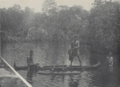
Fishing in Chuuk, 1931
-
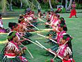
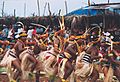
People performing a welcome ceremony on the Ulithi atoll
-
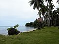
A beach in Chuuk
-
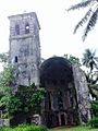
Cathedral of Ponape Belltower, in Kolonia, on the island of Pohnpei, built in 1909 by German Capuchin missionaries
-
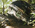
A large (approximately 2.4 m or about 8 ft in height) example of Yapese stone money (Rai stones) in the village of Gachpar
-
Yapese men dancing in traditional dress
-
A shop in Pohnpei selling traditional souveneirs


See also
 In Spanish: Estados Federados de Micronesia para niños
