
Finesville, New Jersey facts for kids
Quick facts for kids
Finesville, New Jersey
|
|
|---|---|

Stone houses on Mount Joy Road
|
|

Finesville, New Jersey
Location in Warren County, New Jersey

Finesville, New Jersey
Location in Hunterdon County, New Jersey

Finesville, New Jersey
Location in New Jersey

Finesville, New Jersey
Location in the United States
|
|
| Country | |
| State | |
| County | Warren |
| Township | Pohatcong |
| Named for | Philip and John Fein |
| Area | |
| • Total | 0.325 sq mi (0.841 km2) |
| • Land | 0.325 sq mi (0.841 km2) |
| • Water | 0.000 sq mi (0.000 km2) 0.00% |
| Elevation | 262 ft (80 m) |
| Population | |
| • Total | 175 |
| • Density | 538.8/sq mi (208.0/km2) |
| Time zone | UTC-5 (Eastern (EST)) |
| • Summer (DST) | UTC-4 (EDT) |
| Area code(s) | 908 |
| FIPS code | 3423340 |
| GNIS feature ID | 876338 2583989 |
Finesville is an unincorporated community and census-designated place (CDP) located within Pohatcong Township in Warren County, New Jersey, United States, that was defined as part of the 2010 United States Census. As of the 2010 Census, the CDP's population was 175.
Contents
History
The community is located along the Musconetcong River between Pohatcong Mountain and Musconetcong Mountain, about a mile east of the Delaware River in a section of the Musconetcong Valley called the Musconetcong Gorge. The settlement was named for Philip and John Fein (often misspelled Fine by locals) who settled in the area from Germany. They built a dam and ran an oil mill, gristmill, sawmill, hotel and a store.
The area was first built up as a permanent settlement due to the construction of Chelsea Forge, built in 1751, a charcoal-iron forge on the Musconetcong. The forge helped to provide the Continental Army with weapons to defend Valley Forge. The Shank Brothers ran a ferry across the Delaware River from the point where the Musconetcong empties into it prior to 1800. The Fein gristmill burned and was later rebuilt as the Riegel Paper Corporation's paper mill and became the Taylor Stiles and Company knife factory. On October 7, 2009, the Finesville-Seigletown Historic District was listed on the New Jersey Register of Historic Places.
Geography
According to the United States Census Bureau, Finesville had a total area of 0.325 square miles (0.841 km2), all of which was land.
Demographics
Census 2010
As of the census of 2010, there were 175 people, 72 households, and 49 families residing in the CDP. The population density was 538.8 per square mile (208.0/km2). There were 87 housing units at an average density of 267.9 per square mile (103.4/km2)*. The racial makeup of the CDP was 97.14% (170) White, 0.00% (0) Black or African American, 0.00% (0) Native American, 1.14% (2) Asian, 0.00% (0) Pacific Islander, 0.57% (1) from other races, and 1.14% (2) from two or more races. [[Hispanic (U.S. Census)|Hispanic or Latino of any race were 2.86% (5) of the population.
There were 72 households out of which 31.9% had children under the age of 18 living with them, 59.7% were married couples living together, 5.6% had a female householder with no husband present, and 31.9% were non-families. 23.6% of all households were made up of individuals, and 5.6% had someone living alone who was 65 years of age or older. The average household size was 2.43 and the average family size was 2.88.
In the CDP, the population was spread out with 22.9% under the age of 18, 4.0% from 18 to 24, 25.1% from 25 to 44, 38.3% from 45 to 64, and 9.7% who were 65 years of age or older. The median age was 43.5 years. For every 100 females there were 110.8 males. For every 100 females ages 18 and old there were 110.9 males.
Sites of interest
- Hunts Meadow – named for patriot Edward Hunt who dug the millrace here and wintered sixty cavalry horses for the Continental Army in 1778.
- Seigletown – named for Benjamin Seigle, a Revolutionary militia captain, who lived here and made red clay pottery called Seigleware. The family owned a farm, a gristmill, clovermill, blacksmith shop and hematite mine.
Transportation

The Mount Joy Road Bridge crosses the Musconetcong River and connects Pohatcong and Holland Townships. This Pratt truss bridge, a contributing structure of the historic district, was built c. 1890 and is the only known example made by G. M. Russling of Hackettstown. County Route 627 (Riegelsville-Warren Glen Road) runs northeast-southwest through the community and intersects with Mountain and Mount Joy Roads.
Images for kids
-
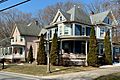
Queen Anne and Colonial Revival houses on County Route 627
-
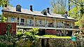
Stone house on Mount Joy Road in Holland Township
-
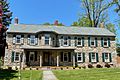
Stone house with Victorian embellishment
-
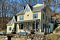
House with Gothic Revival influences
-
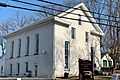
Finesville Church
-
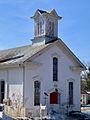
Finesville United Methodist Church


See also
 In Spanish: Finesville para niños
