Fisher County, Texas facts for kids
Quick facts for kids
Fisher County
|
|
|---|---|

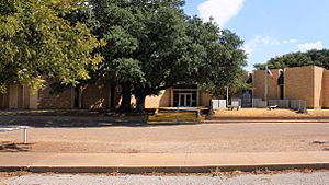
The Fisher County Courthouse
|
|

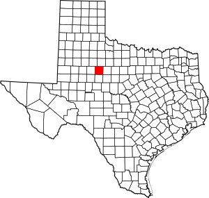
Location within the U.S. state of Texas
|
|
 Texas's location within the U.S. |
|
| Country | |
| State | |
| Founded | 1886 |
| Named for | Samuel Rhoads Fisher |
| Seat | Roby |
| Largest city | Rotan |
| Area | |
| • Total | 902 sq mi (2,340 km2) |
| • Land | 899 sq mi (2,330 km2) |
| • Water | 2.8 sq mi (7 km2) 0.3% |
| Population
(2020)
|
|
| • Total | 3,672 |
| • Density | 4.0710/sq mi (1.5718/km2) |
| Time zone | UTC−6 (Central) |
| • Summer (DST) | UTC−5 (CDT) |
| Congressional district | 19th |
Fisher County is a county located in the U.S. state of Texas. As of the 2020 census, its population was 3,672. The county seat is Roby. The county was created in 1876 and later organized in 1886. It is named for Samuel Rhoads Fisher, a signer of the Texas Declaration of Independence and a Secretary of the Navy of the Republic of Texas. Fisher County was one of 30 prohibition, or entirely dry, counties in Texas, but is now a fully wet county.
From 1921 to 1925, the Democrat Richard M. Chitwood of Sweetwater represented Fisher County in the state House. He left his post to become the first business manager of Texas Tech University, but died the next year.
Contents
History
- 10000 BC - Paleo-Indians were the first inhabitants. Later Native American inhabitants include the Pawnee, Wichita and Waco, Lipan Apache, Kiowa, and Comanche.
- 1876 - The Texas legislature formed Fisher County from Bexar districts. The new county was named after Samuel Rhoads Fisher.
- 1880 - The census reported 136 inhabitants.
- 1881 - The Texas and Pacific Railway routed an east-west branch through Eskota.
- 1885 - The town of Fisher was registered. Swedish immigrants founded the community of Swedonia.
- 1886 - The town of North Roby was registered. Roby eventually won the county seat election over Fisher, but one of the voters, a Mr. Bill Purp, was later discovered to have been actually a dog whose owner lived near Roby.
- 1920 - Fisher County was among Texas leaders in wheat production.
- 1926 - Cotton became king, as 48,000 bales were ginned in the county.
- 1928 - Oil was discovered in the county.
- 1970 - The county's average annual farm income was evenly divided between livestock and crops.
Geography
According to the U.S. Census Bureau, the county has a total area of 902 square miles (2,340 km2), of which 899 square miles (2,330 km2) is land and 2.8 square miles (7.3 km2) (0.3%) is covered by water.
Major highways
Adjacent counties
- Stonewall County (north)
- Jones County (east)
- Nolan County (south)
- Scurry County (west)
- Kent County (northwest)
- Taylor County (southeast)
Demographics
| Historical population | |||
|---|---|---|---|
| Census | Pop. | %± | |
| 1880 | 136 | — | |
| 1890 | 2,996 | 2,102.9% | |
| 1900 | 2,708 | −9.6% | |
| 1910 | 12,596 | 365.1% | |
| 1920 | 11,009 | −12.6% | |
| 1930 | 13,563 | 23.2% | |
| 1940 | 12,932 | −4.7% | |
| 1950 | 11,023 | −14.8% | |
| 1960 | 7,865 | −28.6% | |
| 1970 | 6,344 | −19.3% | |
| 1980 | 5,891 | −7.1% | |
| 1990 | 4,842 | −17.8% | |
| 2000 | 4,344 | −10.3% | |
| 2010 | 3,974 | −8.5% | |
| 2020 | 3,672 | −7.6% | |
| U.S. Decennial Census 1850–2010 2010 2020 |
|||
2020 census
| Race / Ethnicity | Pop 2010 | Pop 2020 | % 2010 | % 2020 |
|---|---|---|---|---|
| White alone (NH) | 2,797 | 2,496 | 70.38% | 67.97% |
| Black or African American alone (NH) | 124 | 92 | 3.12% | 2.51% |
| Native American or Alaska Native alone (NH) | 12 | 15 | 0.30% | 0.41% |
| Asian alone (NH) | 7 | 13 | 0.18% | 0.35% |
| Pacific Islander alone (NH) | 0 | 2 | 0.00% | 0.05% |
| Some Other Race alone (NH) | 7 | 11 | 0.18% | 0.30% |
| Mixed Race/Multi-Racial (NH) | 28 | 70 | 0.70% | 1.91% |
| Hispanic or Latino (any race) | 999 | 973 | 25.14% | 26.50% |
| Total | 3,974 | 3,672 | 100.00% | 100.00% |
Note: the US Census treats Hispanic/Latino as an ethnic category. This table excludes Latinos from the racial categories and assigns them to a separate category. Hispanics/Latinos can be of any race.
Communities
Cities
- Hamlin (mostly in Jones County)
- Roby (county seat)
- Rotan
Unincorporated communities
Ghost Town
See also
 In Spanish: Condado de Fisher para niños

