
Fitchburg Cutoff facts for kids
Quick facts for kids Fitchburg Cutoff |
|
|---|---|

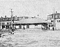
Somerville Highlands station on a 1907 postcard
|
|
| Overview | |
| Owner | Boston and Maine Railroad |
| Termini | Hills Crossing Somerville Junction |
| Stations | 3 |
| History | |
| Opened | 1870, 1881 |
| Closed | 1979–80, 2007 |
| Technical | |
| Line length | 2.8 mi (4.5 km) |
The Fitchburg Cutoff was a rail line running 2.8 miles (4.5 km) from Brighton Street (Hills Crossing station) in Belmont, Massachusetts to Somerville Junction in Somerville, Massachusetts. It was constructed in two segments in 1870 and 1881; passenger service lasted until 1927. Freight service ended in 1979–80 to allow construction of the Red Line Northwest Extension; the line was abandoned in three sections in 1979, 1983, and 2007.
All of the right-of-way, except a short section near Alewife station, has been reused for three connecting rail trails: the Fitchburg Cutoff Path from Brighton Street to Alewife station, the Alewife Linear Park from Alewife to Massachusetts Avenue, and the Somerville Community Path east of Massachusetts Avenue. The paths are part of the Mass Central Rail Trail.
History
Railroad history

The Freight Cutoff linked the Fitchburg Railroad main line (now the MBTA Fitchburg Line) with the Boston and Lowell Railroad (B&L) main line (now the MBTA Lowell Line). It ran east from the Fitchburg Line near Brighton Street (Hills Crossing station) in Belmont, passed through Davis Square (West Somerville) and Somerville Highlands, and connected with the Lowell Line at Somerville Junction. The section east of Clifton Street was built by the B&L in 1870 to connect the newly acquired Lexington and Arlington Railroad (Lexington Branch) to its mainline. Stations were located at North Cambridge [Junction] (North Avenue), West Somerville (Elm Street), Willow Avenue, and Somerville Highlands (at Cedar Street). The latter two were combined as Somerville Highlands (at Highland Road) around 1887.
The western section was built in 1881 by the Central Massachusetts Railroad (which paralleled the Fitchburg Railroad west of Brighton Street) to connect to the B&L; it had no stations between Hills Crossing and North Cambridge. In 1926–27, the B&M built two new sections of track; these allowed the Lexington Branch and the Central Massachusetts Railroad to use the Fitchburg mainline east of Alewife Brook Parkway. On April 24, 1927, passenger service was rerouted over the rebuilt line; the Fitchburg Cutoff (Brighton Street to Somerville Junction) became freight-only, with North Cambridge, West Somerville, and Somervile Highlands stations closed.
All of the cutoff except a short industrial section at the east end was abandoned in 1979 and 1983 to allow for construction of the Red Line Northwest Extension, which runs under the cutoff from Davis Square to east of Alewife station. The short eastern segment was abandoned in 2007.
Path conversion

As part of the Red Line extension, the 1.3-mile (2.1 km) Alewife Linear Park rail trail was constructed from Alewife to Davis, opening in 1985. Except for a short section near Alewife, it follows the former railroad route. The Somerville Community Path opened 0.6 miles (0.97 km) from Davis Square to Cedar Street in 1992, with the 0.4-mile (0.64 km) Massachusetts Avenue–Davis Square segment of the Alewife Linear Park becoming part of the Community Path. The Minuteman Bikeway opened in 1993, connecting to the existing trail at Alewife station. The crossing of Massachusetts Avenue, which originally zig-zagged using existing crosswalks, was signalized as a direct crossing in 2011. A 0.3-mile (0.48 km) extension of the Community Path to Lowell Street opened in 2015; it will be further extended along the Lowell Line in 2021 as part of the Green Line Extension project.
The 0.8-mile (1.3 km) segment west of Alewife station through the Alewife Brook Reservation was used as an unpaved trail; a stone dust surface was added in the 1990s. Construction of the paved Fitchburg Cutoff Path took place from September 2010 to August 2013, with a new bridge built over a stormwater management wetland at Alewife. The planned Belmont Community Path will extend west through Belmont parallel to the Fitchburg Line, connecting with existing sections of the Mass Central Rail Trail.
Images for kids
-
West Somerville station in 1903

