Fitzgibbon, Queensland facts for kids
Quick facts for kids FitzgibbonBrisbane, Queensland |
|||||||||||||||
|---|---|---|---|---|---|---|---|---|---|---|---|---|---|---|---|

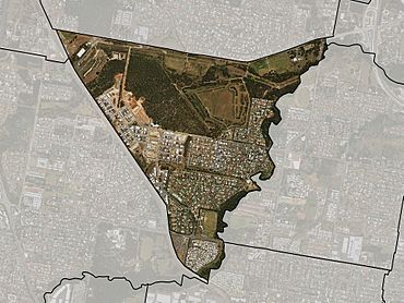
Satellite imagery of Fitzgibbon with suburb boundary shown
|
|||||||||||||||
| Population | 5,656 (2016 census) | ||||||||||||||
| • Density | 1,825/km2 (4,730/sq mi) | ||||||||||||||
| Postcode(s) | 4018 | ||||||||||||||
| Area | 3.1 km2 (1.2 sq mi) | ||||||||||||||
| Time zone | AEST (UTC+10:00) | ||||||||||||||
| Location | 15.6 km (10 mi) N of Brisbane CBD | ||||||||||||||
| LGA(s) | City of Brisbane (Bracken Ridge Ward) |
||||||||||||||
| State electorate(s) | Sandgate | ||||||||||||||
| Federal Division(s) | Petrie | ||||||||||||||
|
|||||||||||||||
Fitzgibbon is a northern suburb of the City of Brisbane, Queensland, Australia. In the 2016 census, Fitzgibbon had a population of 5,656 people.
Demographics
In the 2016 census, Fitzgibbon recorded a population of 5,656 people, 52.4% female and 47.6% male.
The median age of the Fitzgibbon population was 33 years of age, 5 years below the Australian median.
54.9% of people living in Fitzgibbon were born in Australia, compared to the national average of 66.7%; the next most common countries of birth were India 9.6%, New Zealand 5.0%, Philippines 4.4%, England 2.8%, China 2.1%.
61.0% of people spoke only English at home; the next most popular languages were 3.5% Punjabi, 2.7% Hindi, 2.2% Tagalog, 2.2% Cantonese, 2.1% Mandarin.
Education
There are no schools in Fitzgibbon. The nearest primary schools are in neighborouging Taigum and Bracken Ridge. The nearest secondary schools are Sandgate District State High School in neighbouring Deagon and Aspley State High School in Aspley.
A new Catholic secondary school is expected to open in 2022 initially offering Year 7 schooling.


