
Floodplain facts for kids

A floodplain is the flat area around a river that is covered in times of flood. A floodplain is a very fertile area due to the rich alluvium (fine sediment) deposited by floodwaters. This makes floodplains a good place for agriculture. A build-up of alluvium on the banks of a river can create levees, which raise the river bank.
The soils of a floodplain usually consist of clays, silts, sands, and gravels deposited during floods. Floodplains frequently have high soil fertility.
Ssome important agricultural regions, such as the Mississippi river basin and the Nile, rely heavily on the flood plains. Agricultural regions as well as urban areas have developed near or on floodplains to take advantage of the rich soil and fresh water. However, the risk of flooding has led to increasing efforts to control flooding.
Contents
Ecology
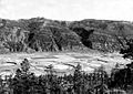
Floodplains support diverse and productive ecosystems.
The flooded of the river (the zone closest to the river bank) provides an ideal environment for many aquatic species. Fish must grow quickly during the flood to survive the drop in water level.
.jpeg)
Floodplain trees are fast-growing and tolerant of root disturbance. Birds are attracted to the rich food supply provided by the flood pulse.
Floodplain forests constituted 1% of the landscape of Europe in the 1800s. They protect waterways from erosion and pollution and reduce the impact of floodwaters. Much of this has been cleared by human activity, especially in Europe. Tropical rivers are less impacted by humans.
Flood control
Floods have been some of the worst natural disasters in history (measured by fatalities). The worst of these, and the worst natural disaster (excluding famine and epidemics) were the 1931 China floods, estimated to have killed millions. This had been preceded by the 1887 Yellow River flood, which killed around one million people, and is the second-worst natural disaster in history.
In the United States the Federal Emergency Management Agency (FEMA) manages the National Flood Insurance Program (NFIP). The NFIP offers insurance to properties located within a flood prone area, as defined by the Flood Insurance Rate Map (FIRM), which depicts various flood risks for a community.
The US government also sponsors efforts to reduce flood impacts. A number of whole towns such as English, Indiana, have been completely relocated from the floodplain. Other smaller-scale efforts include acquiring and demolishing flood-prone buildings or flood-proofing them.
In some floodplains, such as the Inner Niger Delta of Mali, annual flooding events are a natural part of the local ecology and rural economy.
,_Santa_Rosa,_Nueva_Ecija.jpg)
Images for kids
-
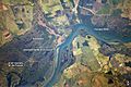
Paraná River floodplain, at its confluence with the headstream of the Paranaíba on the right and the Verde River, near Panorama, Brazil
-
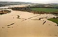
The floodplain after a one-in-10-year flood on the Isle of Wight
-
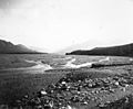
Gravel floodplain of a glacial river near the Snow Mountains in Alaska, 1902
-
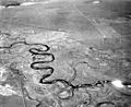
The Laramie River meanders across its floodplain in Albany County, Wyoming, 1949.
-
This aggradational floodplain of a small meandering stream in La Plata County, Colorado, is underlain by silt deposited above a dam formed by a terminal moraine left by the Wisconsin Glacier.
-

A low-lying field in Achterwehr Germany inundated by overflow from a nearby waterway.


See also
 In Spanish: Terreno inundable para niños
