
Florida State Road 44 facts for kids
Quick facts for kids
|
||||
|---|---|---|---|---|
|
SR 44 highlighted in red
|
||||
| Route information | ||||
| Maintained by FDOT | ||||
| Length | 102.786 mi (165.418 km) | |||
| Existed | 1945 renumbering (definition)–present | |||
| Western section | ||||
| Length | 49.155 mi (79.107 km) | |||
| West end | ||||
| Major junctions |
||||
| East end | ||||
| Central section | ||||
| Length | 52.198 mi (84.005 km) | |||
| West end | ||||
| Major junctions |
||||
| East end | ||||
| Eastern section | ||||
| Length | 1.433 mi (2.306 km) | |||
| West end | North Riverside Drive in New Smyrna Beach | |||
| East end | Peninsula Avenue in New Smyrna Beach | |||
| Location | ||||
| Highway system | ||||
| Florida State and County Roads Interstate • US • SR (Pre-1945) • Toll • County
|
||||

State Road 44 (SR 44) is an east–west state highway in the U.S. state of Florida. It runs from Crystal River on the Gulf of Mexico east to New Smyrna Beach on the Atlantic Ocean, passing through Inverness, Wildwood, Leesburg and DeLand.
A section in Lake County, between eastern Leesburg and a point north of Mount Dora, is concurrent with U.S. Highway 441 (SR 500). This concurrency is not signed; signs on US 441 mark it as TO SR 44. The former alignment of SR 44 in that area is now mostly County Road 44, which runs north of Lake Eustis, on the other side as US 441 and current SR 44.
A former western extension of SR 44 from Crystal River to the Gulf of Mexico is now County Road 44. In some locations, it is signed as County Road 44W.
Contents
History
In Lake County, SR 44 originally passed through downtown Leesburg on Main Street, merging with US 441 east of downtown. It then split to the north on current County Road 44, passing north of Lake Eustis. North of Eustis, it turned southeast on present County Road 452, merging with State Road 19 into downtown Eustis, where it turned east on Orange Avenue to rejoin current SR 44 east of Eustis.
The current alignment around the south side of Leesburg was taken over ca. 1986. It had previously been State Road 468 from the west end to U.S. Highway 27 (SR 25) and State Road 33 from roughly Canal Street east to Main Street, but was given to the county by the early 1980s.
At some point, SR 44 from US 441 east of Leesburg to State Road 19 north of Eustis was given to the county and numbered County Road 44; the route via US 441 and SR 19 south of Lake Eustis became SR 44. CR 44 has since been realigned to bypass Eustis to the north.
SR 44 was realigned around downtown Eustis in 2005, taking over what had been County Road 44B between US 441 and SR 44 east of Eustis. The Florida Department of Transportation gave SR 44 west of CR 44B to Lake County. CR 44B had been marked from US 441 as a bypass to SR 44 east and from SR 44 as a bypass to US 441 south, as part of a longer bypass of Eustis also including County Road 44 north and west to SR 19.
Major intersections
| County | Location | Mile | Roads intersected | Notes | |||
|---|---|---|---|---|---|---|---|
| Citrus | Crystal River | 0.000 | 0.000 | ||||
| | 2.378 | 3.827 | |||||
| Lecanto | 6.811 | 10.961 | |||||
| 7.310 | 11.764 | ||||||
| Inverness | 15.906 | 25.598 | |||||
| 16.581 | 26.685 | ||||||
| 16.668 | 26.825 | west end of US 41 / SR 45 overlap | |||||
| 17.615 | 28.349 | east end of US 41 / SR 45 overlap | |||||
| | 21.105 | 33.965 | |||||
| Sumter | | 27.294 | 43.925 | ||||
| | 30.970 | 49.841 | |||||
| | 32.70 | 52.63 | I-75 exit 329 | ||||
| | 33.698 | 54.232 | |||||
| Wildwood | 36.282 | 58.390 | |||||
| Orange Home | 39.387 | 63.387 | |||||
| Wildwood | 41.012 | 66.002 | |||||
| Lake | Leesburg | 44.641 | 71.843 | ||||
| 46.929 | 75.525 | ||||||
| 49.155 | 79.107 | ||||||
| Gap in route | |||||||
| Mount Dora | 0.000 | 0.000 | former CR 44B | ||||
| Eustis | 2.110 | 3.396 | East Orange Avenue - Eustis, Eustis By-Pass to SR 19 north | ||||
| | 4.074 | 6.556 | |||||
| | 7.110 | 11.442 | |||||
| | 8.263 | 13.298 | |||||
| Cassia | 11.672 | 18.784 | |||||
| Crows Bluff | 22.667 | 36.479 | |||||
| St. Johns River | 22.97 | 36.97 | Francis P. Whitehair Bridge | ||||
| Volusia | | 25.472 | 40.993 | ||||
| | 26.172 | 42.120 | |||||
| DeLand | 26.880 | 43.259 | |||||
| 28.140 | 45.287 | ||||||
| | 30.840 | 49.632 | |||||
| DeLand | 32.082 | 51.631 | |||||
| | 33.00 | 53.11 | I-4 exit 118 | ||||
| | 33.770 | 54.348 | Prevatt Avenue - Lake Helen | ||||
| | 39.692 | 63.878 | |||||
| Samsula | 43.244 | 69.594 | |||||
| New Smyrna Beach | 48.16 | 77.51 | I-95 exit 249 | ||||
| 51.191 | 82.384 | ||||||
| 52.1 | 83.8 | interchange; westbound exit and eastbound entrance | |||||
| 52.198 | 84.005 | ||||||
| Gap in route | |||||||
| 0.000 | 0.000 | North Riverside Drive | |||||
| 1.22 | 1.96 | North Causeway over Indian River (Atlantic Intracoastal Waterway) | |||||
| 1.433 | 2.306 | Peninsula Avenue | |||||
| 1.000 mi = 1.609 km; 1.000 km = 0.621 mi | |||||||
Related roads
State Road 44 Business
|
|
|---|---|
| Location: | New Smyrna Beach |
State Road 44 Business is a state road in New Smyrna Beach, Florida. The latest GIS data has it listed as SR 44 even though there are two signs which have "business" tabs on them. Business 44 was the old alignment of SR 44 through downtown New Smyrna Beach.
County Road 44W (Citrus County)
| West Fort Island Trail | |
|---|---|
| Location: | Fort Island-Crystal River |
County Road 44W exists as the western tip of old State Road 44, south of Crystal River. The suffix, "W", was most likely added to not confuse this section with State Road 44, to the north, and to show its location by being west of US 19 and US 98(SR 55). As with the majority of these type of 'coastal spur' routes, in West Central Florida, it is county maintained.
County Road 44A (Sumter County)
|
|
|
|---|---|
| Location: | Wildwood – Orange Home |
County Road 44A exists along the north side of State Road 44 in Wildwood and Orange Home. The road begins southeast of the interchange with Interstate 75, and instantly intersects with CR 225, which runs north and south, while CR 44A runs directly east and west until it curves slightly to the right and becomes Kilgore Street. The road then moves south onto Central Avenue running parallel to the CSX line until reaching Lynum Street, and crosses the tracks until Lynum Street terminates at US 301. County Road 44A then not only crosses US 301 to enter Huey Street, but the wye for the former Leesburg and Tavares railroad line. One block away, CR 44A breaks away from Huey Street and curves south before running along the north side of the right-of-way of the previously mentioned abandoned railroad line. The line contained a series of abandoned freight cars until the 2000s (decade), and the road and railroad line followed each other until CR 44A terminates at a recreational vehicle park in Orange Home.
Lake County
|
|
|
|---|---|
| Location: | Leesburg – Mount Dora |
County Road 44 is a county highway in Lake County in the U.S. state of Florida. It runs from U.S. Route 441 near Leesburg in the west to State Road 44 near Mount Dora in the east.
The western terminus County Road 44 is at an intersection with the concurrency of U.S. Route 441, State Road 44, and State Road 500 at the eastern edge of Leesburg, near Leesburg Regional Airport. From there, it heads northeast past Silver Lake, then east past Lake Eustis, before arriving in the town of Eustis.
In Eustis, CR 44 intersects State Road 19. There, CR 44 splits into two branches. The northern branch heads east from the intersection to its terminus at County Road 44A. The southern branch continues south from the intersection, concurrent with SR 19, before turning east on East Orange Avenue. It then passes by Lake Joanna before terminating at State Road 44 between the towns of Eustis and Mount Dora.
County Road 44 Leg A is a short spur near CR 44's western terminus in Leesburg. It serves as an alternate route for northbound US 441 traffic to reach eastbound CR 44.
County Road 44A
|
|
|
|---|---|
| Location: | Umatilla – Mount Dora |
County Road 44A is an east/west county road in Lake County in the U.S. state of Florida. Its western terminus is at State Road 19 in Umatilla, and its eastern terminus is at State Road 44 about 10 miles (16 km) east of Mount Dora.
The western terminus of County Road 44A is at an intersection with State Road 19 in the town of Umatilla. CR 44A heads out of Umatilla eastward on Rose Street before turning south. Then in Dalhousie Acres (near Lake Dalhousie), it intersects County Road 450A before continuing south towards Eustis.
On the eastern edge of Eustis, CR 44A intersects one of the eastern termini of County Road 44 before turning east once again on DeLand Road. It then continues east on DeLand Road for approximately 9.4 miles (15.1 km), passing by Black Bear Golf Club, before reaching its eastern terminus at State Road 44.
County Road 44B
|
|
|
|---|---|
| Location: | Mount Dora |
County Road 44B, formerly a short north/south county route in the Mount Dora area. In 2004, CR 44B was turned over to State Road 44 when SR 44 was re-routed out of downtown Eustis, with SR 44 becoming a complete eastern and southern bypass of Eustis. The remaining portion of SR 44 through Eustis was reverted to CR 44, and remains unsigned to this day.
County Road 44C
|
|
|
|---|---|
| Location: | Mount Dora |
County Road 44C, is Eudora Road, a short north/south county route also in the Mount Dora area. It spans from the convoluted intersection between Old County Road 441 and the eastern terminus of County Road 19A to US 441-SR 44 almost crossing the Mount Dora-Eustis border.
Images for kids
-
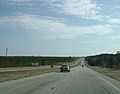
SR 44 as a divided highway west of Inverness.
-
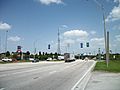
The many truck stops and travel plazas on SR 44 at Interstate 75 in Wildwood. Florida's Turnpike is nearby on the southbound on-ramp.
-
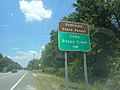
Sign along SR 44 for Seminole State Forest and Camp Boggy Creek.


