Folsom, New Jersey facts for kids
Quick facts for kids
Folsom, New Jersey
|
|
|---|---|
|
Borough
|
|
| Borough of Folsom | |
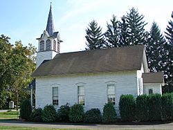
Jacobus Evangelical Lutheran Church
|
|
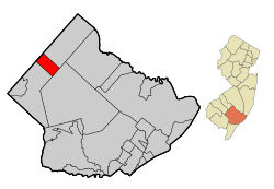
Map of Folsom in Atlantic County. Inset: Location of Atlantic County highlighted in the State of New Jersey.
|
|
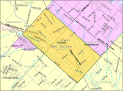
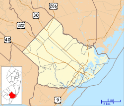
Census Bureau map of Folsom, New Jersey
|
|
| Country | |
| State | |
| County | Atlantic |
| Incorporated | May 23, 1906 |
| Named for | Frances Folsom |
| Government | |
| • Type | Borough |
| • Body | Borough Council |
| Area | |
| • Total | 8.51 sq mi (22.04 km2) |
| • Land | 8.26 sq mi (21.40 km2) |
| • Water | 0.25 sq mi (0.63 km2) 2.88% |
| Area rank | 226th of 565 in state 14th of 23 in county |
| Elevation | 56 ft (17 m) |
| Population | |
| • Total | 1,885 |
| • Estimate
(2019)
|
1,775 |
| • Rank | 492nd of 566 in state 19th of 23 in county |
| • Density | 229.8/sq mi (88.7/km2) |
| • Density rank | 495th of 566 in state 17th of 23 in county |
| Time zone | UTC−05:00 (Eastern (EST)) |
| • Summer (DST) | UTC−04:00 (Eastern (EDT)) |
| ZIP Code |
08037
|
| Area code(s) | 609 exchanges: 561, 567, 704 |
| FIPS code | 3400123940 |
| GNIS feature ID | 0885222 |
| Website | |
Folsom is a borough in Atlantic County, New Jersey, United States. As of the 2010 United States Census, the borough's population was 1,885, reflecting a decline of 87 (-4.4%) from the 1,972 counted in the 2000 Census, which had in turn declined by 209 (-9.6%) from the 2,181 counted in the 1990 Census.
Folsom was incorporated as a borough by an act of the New Jersey Legislature on May 23, 1906, from portions of Buena Vista Township. The borough was named for Frances Folsom, wife of President Grover Cleveland.
New Jersey Monthly magazine ranked Folsom as its 19th best place to live in its 2008 rankings of the "Best Places To Live" in New Jersey.
Contents
Geography
According to the United States Census Bureau, the borough had a total area of 8.438 square miles (21.855 km2), including 8.202 square miles (21.243 km2) of land and 0.236 square miles (0.612 km2) of water (2.80%).
Unincorporated communities, localities and place names located partially or completely within the borough include Penny Pot.
The borough is one of 56 South Jersey municipalities that are included within the New Jersey Pinelands National Reserve, a protected natural area of unique ecology covering 1,100,000 acres (450,000 ha), that has been classified as a United States Biosphere Reserve and established by Congress in 1978 as the nation's first National Reserve. All of the borough is included in the state-designated Pinelands Area, which includes portions of Atlantic County, along with areas in Burlington, Camden, Cape May, Cumberland, Gloucester and Ocean counties.
Demographics
| Historical population | |||
|---|---|---|---|
| Census | Pop. | %± | |
| 1910 | 232 | — | |
| 1920 | 217 | −6.5% | |
| 1930 | 219 | 0.9% | |
| 1940 | 229 | 4.6% | |
| 1950 | 292 | 27.5% | |
| 1960 | 482 | 65.1% | |
| 1970 | 1,767 | 266.6% | |
| 1980 | 1,892 | 7.1% | |
| 1990 | 2,181 | 15.3% | |
| 2000 | 1,972 | −9.6% | |
| 2010 | 1,885 | −4.4% | |
| 2019 (est.) | 1,775 | −5.8% | |
| Population sources: 1910-2000 1910-1920 1910 1910-1930 1930-1990 2000 2010 |
|||
Census 2010
As of the census of 2010, there were 1,885 people, 688 households, and 526 families residing in the borough. The population density was 229.8 per square mile (88.7/km2). There were 717 housing units at an average density of 87.4 per square mile (33.7/km2)*. The racial makeup of the borough was 90.93% (1,714) White, 4.19% (79) Black or African American, 0.16% (3) Native American, 0.85% (16) Asian, 0.16% (3) Pacific Islander, 1.86% (35) from other races, and 1.86% (35) from two or more races. [[Hispanic (U.S. Census)|Hispanic or Latino of any race were 6.74% (127) of the population.
There were 688 households out of which 28.2% had children under the age of 18 living with them, 60.5% were married couples living together, 11.8% had a female householder with no husband present, and 23.5% were non-families. 17.4% of all households were made up of individuals, and 6.1% had someone living alone who was 65 years of age or older. The average household size was 2.73 and the average family size was 3.08.
In the borough, the population was spread out with 22.1% under the age of 18, 8.0% from 18 to 24, 25.1% from 25 to 44, 33.7% from 45 to 64, and 11.1% who were 65 years of age or older. The median age was 41.8 years. For every 100 females there were 98.8 males. For every 100 females ages 18 and old there were 96.7 males.
The Census Bureau's 2006-2010 American Community Survey showed that (in 2010 inflation-adjusted dollars) median household income was $65,795 (with a margin of error of +/- $5,755) and the median family income was $67,778 (+/- $7,595). Males had a median income of $50,192 (+/- $6,784) versus $36,471 (+/- $4,204) for females. The per capita income for the borough was $29,446 (+/- $2,979). About 3.2% of families and 5.6% of the population were below the poverty line, including 6.9% of those under age 18 and 8.9% of those age 65 or over.
Census 2000
As of the 2000 United States Census there were 1,972 people, 671 households, and 552 families residing in the borough. The population density was 238.5 people per square mile (92.1/km2). There were 702 housing units at an average density of 84.9 per square mile (32.8/km2). The racial makeup of the borough was 91.73% White, 4.41% African American, 0.15% Native American, 0.86% Asian, 0.15% Pacific Islander, 1.57% from other races, and 1.12% from two or more races. 3.45% of the population were Hispanic or Latino of any race.
There were 671 households, out of which 37.1% had children under the age of 18 living with them, 64.4% were married couples living together, 14.2% had a female householder with no husband present, and 17.7% were non-families. 13.7% of all households were made up of individuals, and 3.9% had someone living alone who was 65 years of age or older. The average household size was 2.93 and the average family size was 3.18.
In the borough the population was spread out, with 24.9% under the age of 18, 8.8% from 18 to 24, 30.0% from 25 to 44, 26.5% from 45 to 64, and 9.8% who were 65 years of age or older. The median age was 38 years. For every 100 females, there were 96.2 males. For every 100 females age 18 and over, there were 92.6 males.
The median income for a household in the borough was $56,406, and the median income for a family was $59,231. Males had a median income of $39,659 versus $30,000 for females. The per capita income for the borough was $20,617. 5.7% of the population and 4.2% of families were below the poverty line. Out of the total population, 4.3% of those under the age of 18 and 4.9% of those 65 and older were living below the poverty line.
Transportation
Roads and highways
As of May 2010[update], the borough had a total of 27.69 miles (44.56 km) of roadways, of which 17.32 miles (27.87 km) were maintained by the municipality, 4.00 miles (6.44 km) by Atlantic County and 6.37 miles (10.25 km) by the New Jersey Department of Transportation.
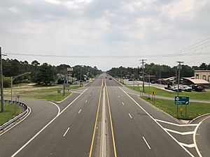
Three significant highways directly serve Folsom. U.S. Route 322 follows the Black Horse Pike across the borough from northwest to southeast, connecting Folsom to Monroe Township and Hamilton Township. New Jersey Route 54 is oriented northeast to southwest across the borough, linking Folsom with Hammonton and Buena Vista Township. New Jersey Route 73 heads north from U.S. Route 322, briefly clipping Hammonton before entering Winslow Township.
Public transportation
NJ Transit provides bus service on the 315 route that runs between Cape May and Philadelphia.
Education
The Folsom Borough School District serves public school students in pre-kindergarten through eighth grade at Folsom School. As of the 2018–19 school year, the district, comprised of one school, had an enrollment of 410 students and 39.0 classroom teachers (on an FTE basis), for a student–teacher ratio of 10.5:1.
For ninth through twelfth grades, public school students attend Hammonton High School, in Hammonton as part of a sending/receiving relationship with the Hammonton Public Schools, alongside students from Waterford Township, who attend for grades 7-12 as part of an agreement with the Waterford Township School District. As of the 2018–19 school year, the high school had an enrollment of 1,393 students and 97.4 classroom teachers (on an FTE basis), for a student–teacher ratio of 14.3:1.
City public school students are also eligible to attend the Atlantic County Institute of Technology in the Mays Landing section of Hamilton Township or the Charter-Tech High School for the Performing Arts, located in Somers Point.
Notable people
People who were born in, residents of, or otherwise closely associated with Folsom include:
- Jimmy Horton (born 1956), racecar driver.
- Kenneth LeFevre (born 1945), member of the New Jersey General Assembly from 1996 to 2002.
- E. B. Lewis (born 1956), illustrator who won the 2006 Charlotte Zolotow Award for his illustrations of My Best Friend by Mary Ann Rodman.
- G. R. Smith (born 1981), professional stock car racing driver who has raced in the NASCAR Camping World Truck Series and the ARCA Racing Series.
See also
 In Spanish: Folsom (Nueva Jersey) para niños


