Forsyth County, North Carolina facts for kids
Quick facts for kids
Forsyth County
|
|||
|---|---|---|---|
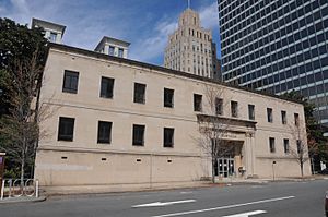
Forsyth County Courthouse in Winston-Salem.
|
|||
|
|||
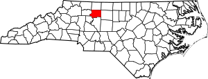
Location within the U.S. state of North Carolina
|
|||
 North Carolina's location within the U.S. |
|||
| Country | |||
| State | |||
| Founded | January 16, 1849 | ||
| Named for | Colonel Benjamin Forsyth | ||
| Seat | Winston-Salem | ||
| Largest city | Winston-Salem | ||
| Area | |||
| • Total | 413 sq mi (1,070 km2) | ||
| • Land | 408 sq mi (1,060 km2) | ||
| • Water | 4.5 sq mi (12 km2) 1.1%% | ||
| Population
(2020)
|
|||
| • Total | 382,590 | ||
| • Density | 926.4/sq mi (357.7/km2) | ||
| Time zone | UTC−5 (Eastern) | ||
| • Summer (DST) | UTC−4 (EDT) | ||
| Congressional districts | 6th, 10th | ||
Forsyth County is located in the northwest Piedmont of the U.S. state of North Carolina. As of the 2020 census, the population was 382,590, making it the fourth-most populous county in North Carolina. Its county seat is Winston-Salem. Forsyth County is part of the Winston-Salem, NC, Metropolitan Statistical Area, which is also included in the Greensboro-Winston-Salem-High Point, NC, Combined Statistical Area. Portions of Forsyth County are in the Yadkin Valley wine region.
Contents
History
The county was formed in 1849 from Stokes County. It was named for Colonel Benjamin Forsyth, who was killed in the War of 1812.
Geography
According to the U.S. Census Bureau, the county has a total area of 413 square miles (1,070 km2), of which 408 square miles (1,060 km2) is land and 4.5 square miles (12 km2) (1.1%) is water.
Adjacent counties
- Stokes County - north
- Rockingham County - northeast
- Guilford County - east
- Davidson County - south
- Davie County - southwest
- Yadkin County - west
- Surry County - northwest
Major highways
 I-40
I-40 I-40 Bus.
 I-74
I-74 US 52
US 52 US 158
 US 311
 US 421
 NC 8
NC 8 NC 65
NC 65 NC 66
NC 66 NC 67
NC 67 NC 109
 NC 150
Demographics
| Historical population | |||
|---|---|---|---|
| Census | Pop. | %± | |
| 1850 | 11,168 | — | |
| 1860 | 12,692 | 13.6% | |
| 1870 | 13,050 | 2.8% | |
| 1880 | 18,070 | 38.5% | |
| 1890 | 28,434 | 57.4% | |
| 1900 | 35,261 | 24.0% | |
| 1910 | 47,311 | 34.2% | |
| 1920 | 77,269 | 63.3% | |
| 1930 | 111,681 | 44.5% | |
| 1940 | 126,475 | 13.2% | |
| 1950 | 146,135 | 15.5% | |
| 1960 | 189,428 | 29.6% | |
| 1970 | 214,348 | 13.2% | |
| 1980 | 243,683 | 13.7% | |
| 1990 | 265,878 | 9.1% | |
| 2000 | 306,067 | 15.1% | |
| 2010 | 350,670 | 14.6% | |
| 2020 | 382,590 | 9.1% | |
| U.S. Decennial Census 1790-1960 1900-1990 1990-2000 2010-2013 |
|||
2020 census
| Race | Number | Percentage |
|---|---|---|
| White (non-Hispanic) | 208,126 | 54.4% |
| Black or African American (non-Hispanic) | 93,738 | 24.5% |
| Native American | 978 | 0.26% |
| Asian | 9,179 | 2.4% |
| Pacific Islander | 233 | 0.06% |
| Other/Mixed | 15,648 | 4.09% |
| Hispanic or Latino | 54,688 | 14.29% |
As of the 2020 United States census, there were 382,590 people, 148,151 households, and 90,837 families residing in the county.
Communities
Cities
- High Point (mostly in Guilford County)
- Winston-Salem (county seat)
Towns
- Bethania
- Kernersville
- King (mostly in Stokes County)
- Lewisville
- Rural Hall
- Walkertown
Villages
Census-designated place
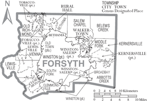
Townships
- Abbots Creek
- Belews Creek
- Bethania
- Broadbay
- Clemmonsville
- Kernersville
- Lewisville
- Middle Fork I
- Middle Fork II Township
- Old Richmond
- Old Town
- Salem Chapel
- South Fork
- Vienna
- Winston
Former township
- Middle Fork Township was split into Middle Fork I Township and Middle Fork II Township in 2003.
Unincorporated communities
See also
 In Spanish: Condado de Forsyth (Carolina del Norte) para niños


